Severe Weather 101
Tornado Detection
Forecasters and storm spotters have learned to recognize certain thunderstorm features and structure that make tornado formation more likely. Some of these are visual cues, like the rear-flank downdraft, and others are particular patterns in radar images, like the tornadic vortex signature (TVS).
Storm spotters have been trained to recognize tornado conditions and report what they see to the National Weather Service. Storm spotters can be emergency managers or even local people with a keen interest in severe weather who have taken formal storm spotter training in their community.
Computer programs, called algorithms, analyze Doppler radar data and display it in ways that make it easier for forecasters to identify dangerous weather. A storm with a tornado observed by radar has certain distinguishing features and forecasters are trained to recognize them.
When a Doppler radar detects a large rotating updraft that occurs inside a supercell, it is called a mesocyclone. The mesocyclone is usually 2-6 miles in diameter, and is much larger than the tornado that may develop within it.
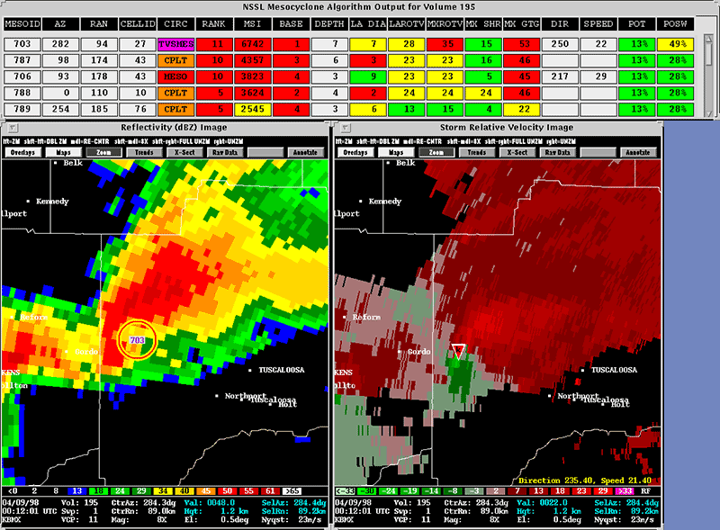
Mesocyclone Detection Algorithm Display [+]
What we do: NSSL developed the WSR-88D Mesoscale Detection Algorithm to analyze radar data and look for a rotation pattern meeting specific criteria for size, strength, vertical depth, and duration. A mesocyclone is usually 2-6 miles in diameter, and is much larger than the tornado that may develop within it.
NSSL researchers discovered the Tornado Vortex Signature (TVS), a Doppler radar velocity pattern that indicates a region of intense concentrated rotation. The TVS appears on radar several kilometers above the ground before a tornado touches ground. It has smaller, tighter rotation than a mesocyclone. While the existence of a TVS does not guarantee a tornado, it does strongly increase the probability of a tornado occurring.
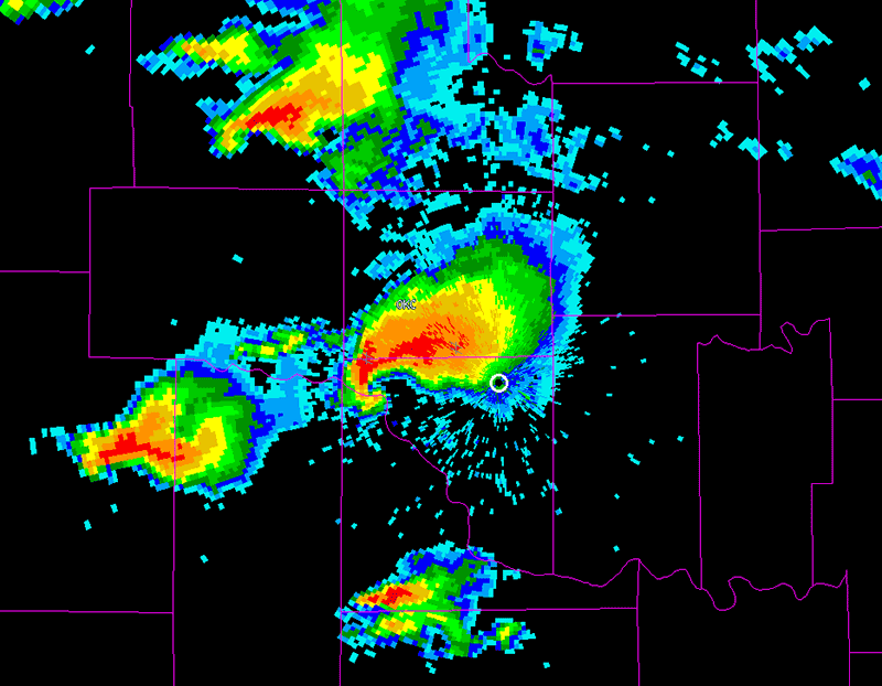
Hook echo [+]
A “hook echo” describes a pattern in radar reflectivity images that looks like a hook extending from the radar echo, usually in the right-rear part of the storm (relative to the motion of the storm). A hook is often associated with a mesocyclone and indicates favorable conditions for tornado formation. The hook is caused by the rear flank downdraft and is the result of precipitation wrapping around the back side of the updraft.
Dual-polarization radar technology, installed on NWS radars, can detect the presence of random shaped and sized targets like leaves, insulation or other debris. This gives meteorologists a high degree of confidence that a damaging tornado is on the ground, and is especially helpful at night when tornadoes are difficult to see with the human eye.
What we do: NSSL engineers and scientists have adapted phased array technology, formerly used on Navy ships for surveillance, for use in weather forecasting. Phased array technology can scan an entire storm in less than one minute, allowing forecasters to see signs of developing tornadoes well ahead of current radar technology. NSSL uses a mobile Doppler radar to position close to tornadic storms to scan the entire lifecycle of a tornado. This helps us understand atmospheric processes to help improve forecasts of significant weather events.
Researchers at NSSL are developing the New Tornado Detection Algorithm, or NTDA, to help NWS forecasters better detect tornadoes and hail. The NTDA provides an operations update to the Tornado Detection Algorithm, also developed at NSSL, which is currently in use. The NTDA uses machine learning to evaluate storm criteria and calculates the probability of whether a tornado is present with each detection. The algorithm takes into account multiple storm aspects, including information available from dual-polarization radar, and reviews the statistics related to each evaluated element. All of these factors are then combined by the NTDA to yield a probability of a tornado presence. The NTDA is currently being tested in NOAA’s Hazardous Weather Testbed on its performance and how NWS forecasters like the look and feel of the product.
NSSL's On-Demand web-based tool helped confirm when and where tornadoes occurred by mapping circulations on satellite images. NWS forecasters could quickly review warnings and check their accuracy with this system. Emergency responders and damage surveyors also used On-Demand to produce high-resolution street maps of potentially damaged areas so they can more effectively begin rescue and recovery efforts. Today, circulation maps are available as part of the multi-radar, multi-sensor (MRMS) system developed at NSSL.
NSSL's second generation Warning Decision Support System, WDSS-II,was an advanced algorithm development and visualization platform that accepted data from multiple sources and organizes it in ways that conveyed critical severe weather information to warning meteorologists.
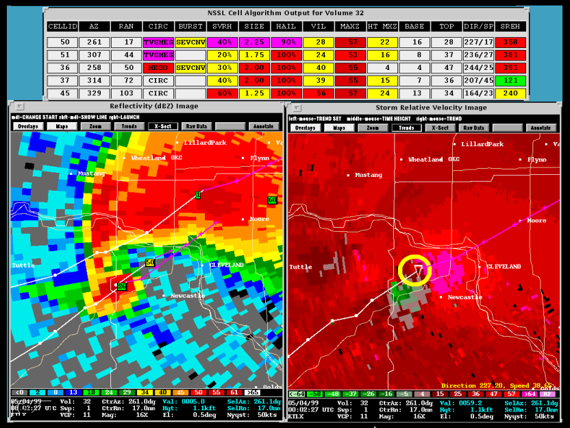
Tornadic Vortex Signature in radar data. In this display, the circle is a mesocyclone, and the triangle is the TVS. [+]
NSSL built the first real-time displays of Doppler velocity data. This led to an NSSL scientist's discovery of the Tornadic Vortex Signature in radar velocity data in the 1970s. These developments helped spur deployment of the WSR-88D NEXRAD radar network. The Department of Commerce recognized NSSL's contribution to the NEXRAD program and to our Nation by awarding a Gold Medal to NSSL.
NSSL made the first observations of a tornadic storm with two Doppler radars (called dual-Doppler). The radars were located about 40 miles from each other and were able to record data on the same storm but from two different perspectives. The data was used to map the structure of a tornadic storm at several altitudes.
NSSL has used an airborne Doppler radar (installed on NOAA's P-3 research aircraft) to study storms. The first direct measurements of a tornado recorded with an airborne Doppler radar were made by NSSL. New concepts of making dual-Doppler measurements using the WSR-88D with the airborne Doppler were first tested in 1989 and are now used routinely.
The Oklahoma Weather Alert Remote Notification (OK-WARN) program provides deaf and hard-of-hearing Oklahomans access to emergency severe weather information via alphanumeric pagers and/or E-mail addresses. NSSL scientist Vincent Wood received the Department of Commerce Gold Medal award for his part in developing this hazardous weather pager program.