
About NSSL: NSSL History
NSSL's commitment to improve our knowledge of severe weather and to develop new tools to better forecast and warn of its hazards has endured for more than half a century.
View an interactive, multimedia timeline of NSSL's major accomplishments →
Here is a list of the highlights:
- 1962
- A small group of researchers with the U.S. Weather Bureau's National Severe Storms Project (NSSP) moves from Kansas City to the Weather Radar Laboratory in Norman, Oklahoma, and begins work with a recently installed research Weather Surveillance Radar-1957 (WSR-57).
- 1964
- The entire National Severe Storms Project operation moves to Norman and is reorganized as the National Severe Storms Laboratory with Edwin Kessler as the new director.
- In 1956, Cornell Aeronautical Laboratory built a 3 cm continuous wave Doppler radar that used one antenna to transmit and another to receive. This radar was designed to detect very high wind speeds in tornadoes, but could not determine the distance to the tornadoes. In 1964, NSSL engineers modifed this radar to transmit in pulses. The pulsed Doppler radar could receive data in between each transmit pulse, eliminating the need for two antennas and solving the distance problem.
- 1965
- Aircraft flew into thunderstorms to measure turbulence during Project Rough Rider in the 1960s, '70s and early '80s. This data was combined with measurements of the intensity of the rain from the WSR-57 to understand how thunderstorm echoes and turbulence are related. This research led to improved commercial airline safety guidelines in the vicinity of thunderstorms that are still in use today.
- 1967
- Researchers place two Doppler radars so that each has a different view of the same storm. It is the first dual-Doppler experiment in the United States.
- 1969
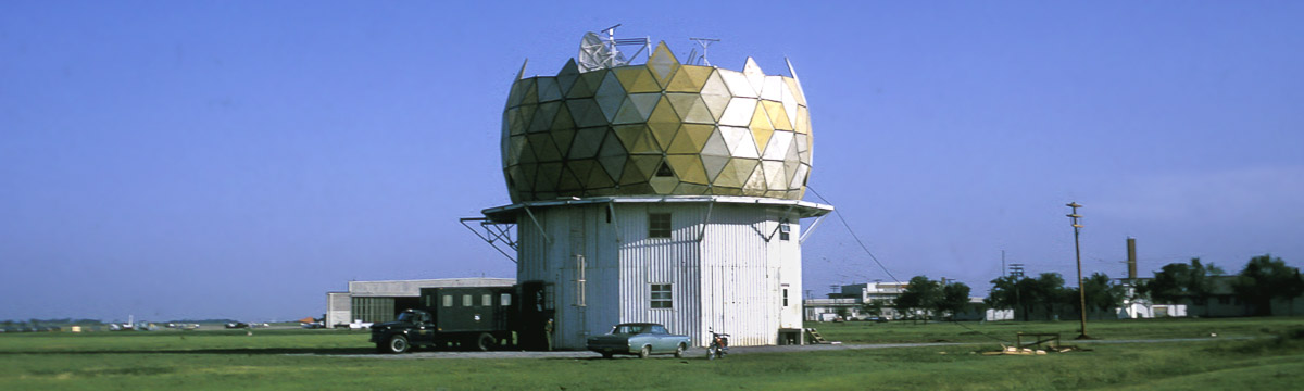
- NSSL obtains a surplus 10 cm Doppler radar that had been used by the U.S. Air Force.
- 1971
- The experimental NSSL Doppler radar becomes operational.
- 1973
- NSSL engineers create a contoured black and white display, a vast improvement from the grid of numbers currently in use.
- On May 24, an NSSL team intercepts a storm being scanned by the NSSL Doppler radar. The team documents the entire life cycle of the tornado on film. Researchers are able to compare the film images with Doppler radar data and discover a pattern that meant the tornado was forming before it appeared on film. They name this pattern the Tornado Vortex Signature (TVS). This important discovery eventually led to NOAA to deploying a nationwide network of Doppler radars.
Learn more about the Union City tornado and the birth of Doppler weather radar → - This same year, NSSL commissions a second Doppler radar 15 miles west of Oklahoma City and names it the Cimarron radar. This gives NSSL the ability to conduct dual-Doppler experiments by simultaneously scanning the same storm with both radars.
- 1975
- NSSL's legacy in organized field experiments begins with the Tornado Intercept Project in 1975 led by NSSL's Bob Davies-Jones. NSSL's Don Burgess provided storm intercept crews with live radar information via radio—and the term, “nowcaster,” was born.
- NSSL engineers develop a color display for Doppler radar data.
- 1976
- NSSL conducts the Joint Doppler Operational Project (JDOP) to prove that Doppler radar could improve the nation's ability to warn for severe thunderstorms and tornadoes. This led to the decision in 1979 by the National Weather Service (NWS), the U.S. Air Force's Air Weather Service, and the Federal Aviation Administration (FAA) to include Doppler capability in their future operational radars.
- 1981–1984
- NSSL attempts to deploy TOTO, the TOtable Tornado Observatory in the path of an oncoming tornado. They are unsuccessful.
- 1985
- NSSL researchers develop and test a technology that transmits radar energy pulses both horizontally and vertically on the Cimarron radar. They discover this capability provides valuable information about the type and amount of precipitation that is falling and call it dual-polarization technology.
- 1987
- NSSL develops and tests radar algorithms that detect and notify forecasters of hail, tornado circulations, downbursts and gust fronts.
- 1988
- Engineers convert the Cimarron radar to dual-polarization.
- 1990
- NSSL researchers begin development of the Warning Decision Support System (WDSS) designed to enhance National Weather Service warning capabilities. WDSS contains a combination of sophisticated severe weather detection algorithms and an innovative, user-friendly display.
- 1991
- NSSL participates in the Cooperative Oklahoma Profiler Studies of 1991 (COPS-91) and uses instrumented aircraft and a ground-based network of instruments to sample tornadic supercells.
- 1994
- The Verification of the Origins of Rotation in Tornadoes EXperiment (VORTEX) begins. VORTEX is a two-year project designed to answer a number of ongoing questions about the causes of tornado formation. It was a near record for the fewest number of tornadoes in the VORTEX area, but operations still occurred on 18 days and collected data on storms on 9 days.
- NSSL partners with the University of Oklahoma to develop the first mobile Doppler radar.
- 1995
- The Department of Commerce awards NSSL a Gold Medal for work leading up to and ongoing support of the national deployment of Weather Surveillance Radar-1988 Doppler (WSR-88D) radars.
- VORTEX intercepts nine tornadoes; two of them were very large and violent.
- The mobile Doppler radar is operational and provides revolutionary data on several tornadic storms during VORTEX.
- NSSL and SPC begin a long-term collaboration to address operational severe weather forecasting issues.
- 1996
- NSSL supports weather-decision making during the 1996 Summer Olympic Games in Atlanta, Ga. with the Warning Decision Support System (WDSS).
- NSSL designs and develops software allowing the WSR-88D system to be more easily modified and updated.
- 1997
- The National Severe Storms Forecast Center moves from Kansas City to Norman and changes its name to the Storm Prediction Center. This was a deliberate move to collocate research with operations.
- NSSL receives permission to upgrade their prototype WSR-88D radar with dual-polarization technology to determine the practicality of upgrading the nationwide network of Doppler radars.
- NSSL scientists lead the Thunderstorm Initiation Mobile Experiment (TIMEx), an organized effort designed to answer specific questions concerning convective initiation.
- NSSL conducts the SubVORTEX project as an extension of VORTEX with fewer vehicles and a tighter focus.
- 1998
- NSSL coordinates the MEaPRS (MEsoscale Convective System Electrification and Polarimetric Radar Study) project using an array of fixed and mobile sensors, including a P-3 research aircraft and several mobile laboratories, to simultaneously sample a target Mesoscale Convective System.
- NSSL's Warning Decision Support System (WDSS) is included in the Advanced Weather Information Processing System (AWIPS) to provide forecasters with the latest severe weather warning technology.
- It is the 50th Anniversary of the first tornado forecast.
- 1999
- NSSL and OU conduct VORTEX-99, a small follow-on project to the original VORTEX. VORTEX-99 is operating when an F5 tornado tears through parts of south Oklahoma City on May 3, 1999.
- NWS forecasters rely on NSSL's Warning Decision Support System (WDSS) to make timely and accurate tornado warnings during the deadly tornado outbreak in central Oklahoma on May 3, 1999.
- NSSL unveils the next-generation of WDSS: WDSS-II (WDSS-Integrated Information), redesigned to allow for easier development and testing of severe weather detection and prediction applications using all operational data available in AWIPS.
- 2000
- NSSL receives funds to build the National Weather Radar Testbed (NWRT) facility in Norman to develop and test phased array radar technology. Phased array radar can scan the skies in less than a minute, five times faster than current radars.
- NSSL joins a coalition of researchers to design, build and deploy a mobile dual-radar system: the Shared Mobile Atmospheric Research and Teaching Radars (SMART-R).
- NSSL scientists direct research aircraft in Europe's Mesoscale Alpine Project.
- The Intermountain Precipitation Experiment (IPEX) collects data on terrain-induced precipitation events and interactions producing lake-effect snow bands in northern Utah.
- NSSL conducts the Severe Thunderstorm Electrification and Precipitation Study (STEPS) field program near the Colorado-Kansas border to study thunderstorms and lightning on the high plains for eight weeks.
- NSSL develops a real-time multi-sensor algorithm to estimate rain and snowfall called QPE-SUMS (Quantitative Precipitation Estimation and Segregation Using Multiple Sensors).
- An NSSL scientist develops a severe weather climatology model telling us when and where severe weather is most likely to happen anywhere in the U.S.
- NSSL and the NWS publicly fight the myth that highway overpasses are safe shelters in tornadoes.
- A partnership begins with North Carolina groups to bring advanced flood monitoring and warning technologies to the coastal Carolinas.
- The first NOAA Hazardous Weather Testbed (HWT) Spring Experiment to evaluate operational and experimental models and algorithms with the NWS begins and becomes an annual event.
- NSSL's Warning Decision Support System (WDSS) provides weather support during the 2000 Summer Olympic Games, in Sydney, Australia.
- 2001
- NSSL participates in the Pacific Land falling Jets Experiment (PACJET) along and offshore of the U.S. Pacific coastline to improve short-term forecasts and warnings of floods, damaging winds and other severe weather.
- A fire destroys the NSSL field research equipment storage facility including one of two mobile radars, a new lightning mapping array, a new mobile laboratory, a mobile mesonet instrumented vehicle, and many valuable instruments.
- An NSSL scientist develops the Hazardous Weather Pager Program that sends lifesaving weather messages via pagers to subscribers with hearing disabilities.
- 2002
- The Joint Polarization Experiment (JPOLE) tests the polarimetric capabilities of the WSR-88D in Norman, OK in an operational demonstration in collaboration with operational hydrologists, meteorologists and aviation users.
- NSSL partners with researchers from around the world for the International H20 (IHOP) field project. The goal is to improve understanding of the process of convective initiation and boundary evolution, and learn what types of data are needed to make forecasts of thunderstorms and rainfall amounts more specific.
- 2003
- The NWRT Phased Array Radar (PAR) becomes operational.
- NSSL completes Project CRAFT; successfully proving that real-time access to high-resolution radar data from multiple radars is technically possible and economically feasible.
- NSSL participates in the Bow Echo and Mesoscale Convective Vortices Experiment (BAMEX) during May–June 2003 to understand the processes and improve prediction of systems that produce severe winds.
- The Oklahoma Lightning Mapping Array (O-LMA) becomes operational and is used by NSSL researchers to investigate how lightning characteristics relate to updrafts, precipitation, and severe storm processes.
- The Thunderstorm Electrification and Lightning Experiment (TELEX) begins the first year of a two year project to learn how lightning and other electrical storm properties are dependent on storm characteristics.
- 2004
- NEXRAD Program Management Committee approves taking first steps towards upgrading the national operational WSR-88D network to include dual-polarimetric capabilities developed by NSSL.
- It is the second year of TELEX.
- NSSL seamlessly mosaics all 130 NWS and Department of Defense weather radars across the U.S. to provide the first high-resolution depiction of storms and quantitative precipitation estimation products from coast-to-coast in real-time.
- Data collection with the NWRT Phased Array Radar (PAR) begins.
- 2005
- NSSL celebrates its 40th Anniversary.
- NSSL SMART-R team operates the mobile radar in California to help forecast debris flows in areas burned by wild fires.
- The NSSL-developed multi-sensor technology to improve severe weather warning decision-making will be moved into operations.
- The first National Weather Festival draws 1000 visitors to tour NSSL facilities.
- Students make phone calls to collect reports of severe weather from the public as part of the Severe Hazards Analysis and Verification Experiment (SHAVE).
- 2006
- NSSL moves into the new National Weather Center six miles south of their previous location.
- PAR detects rotation, hail, microbursts and gust fronts well ahead of other radars due to its rapid scan capability.
- NSSL and the SPC formally organize their collaboration towards improving severe thunderstorm and tornado watches and warnings in the new NOAA Hazardous Weather Testbed (HWT).
- NSSL leads the Coastal and Inland Flood Observation and Warning (CI-FLOW) Project to improve flood forecasts and warnings in coastal areas.
- NSSL deploys a mobile radar to provide data for the Flash Flood and Debris Flow project in California.
- 2007
- NSSL introduces real-time PAR data to forecasters in a simulated operational environment and receive positive feedback. The project is called “Phased Array Radar Innovative Sensing Experiment” (PARISE) and is ongoing.
- NSSL researchers create the Meteorological Development Lab to invite collaboration and discussion on current projects being developed.
- NSSL launches a new Web site to reach out to a wider audience including students, researchers, colleagues, media and the public.
- The NOAA HWT identifies two interrelated areas of focus creating the Experimental Warning Program to target improving severe weather warning precision, and the Experimental Forecast Program to improve predictions of hazardous convective weather phenomena.
- NSSL's prototype Four-Dimensional Stormcell Investigator (FSI) designed to “slice and dice” storms is alpha-tested in three NWSFO's and will be implemented at all WFO's.
- PAR scans landfalling Tropical Storm Erin as it tracks over Oklahoma.
- NSSL launches a “Video Highlights” Web page.
- 2008
- NSSL adds a mobile X-Band dual-polarized radar (NOXP) to the armada of mobile research equipment.
- NSSL operates the SMART-R in Arizona to observe the lifecycle of strong microbursts and assess their impact on the Salt River Project's electrical power transmission and infrastructure.
- NSSL's SMART-R team transmits mobile radar data to the NWSFO in Oxnard, CA in real-time, aiding the office in their decision to issue a flash flood warning.
- The NWS in Little Rock, Ark. uses NSSL's “On-Demand” severe storm verification system to help with damage surveys and warning verification following the Super Tuesday tornado outbreak in the south-central U.S.
- 2009
- NSSL embraces social networking by creating a Facebook and Twitter presence.
- The Verification of the Origins of Rotation in Tornadoes Experiment 2009-2010 (VORTEX2) begins. It is the largest field tornado research project in history deploying ten mobile radars and 40 other instrumented vehicles. VORTEX2 is working to better understand how, when and why some supercell thunderstorms produce tornadoes and others do not. The project was designed to observe all scales of motion from the thunderstorm down to the tornado.
- VORTEX2 collects data on a tornado in LaGrange, Wyoming using all of their mobile research equipment. It remains the best-sampled storm in history.
- 2010
- An NSSL team deploys a dual-polarized mobile radar and a team of researchers to support the 2010 Winter Olympic Games through their participation in Science and NOWcasting of Olympic Weather for Vancouver (SNOW-V10). It is a unique opportunity for international collaboration on the science of winter nowcasting in complex terrain.
- NSSL/CIMMS team win the prestigious Vaisala Award for their Outstanding Research Paper, “Rapid Sampling of Severe Storms by the National Weather Radar Testbed Phased Array Radar.”
- NSSL deploys a mobile radar in the Southwest Colorado Radar Project to collect data on thunderstorm rainfall to better understand and forecast flash flooding caused by the Southwest Monsoon.
- The Central Oklahoma chapter of the American Red Cross uses NSSL's WDSS-II: On Demand system to assess tornado disaster areas much faster than before.
- VORTEX2 continues and logs over 25,000 miles for each vehicle over the two-year project sampling 36 supercell thunderstorms and 11 tornadoes.
- The Kimpel Symposium, a review of successful meteorological programs in Oklahoma including contributions made by Dr. Jeff Kimpel, and a look into the future of severe weather research, was held at the National Weather Center on Friday, June 18, 2010.
- More than 5000 visitors attend the 6th annual National Weather Festival at the National Weather Center in Norman, Okla.
- 2011
- NSSL deploys a mobile radar to help with winter weather forecasts over southwest Colorado.
- The first annual Warn-on-Forecast workshop was held in Norman.
- NSSL's mobile radar scans the early and mature stages of the first tornado in an outbreak in central Oklahoma. A long track EF-4 tornado is captured by PAR and tornadoes threaten the National Weather Center building.
- NSSL launches the 2-Dimensional Video Disdrometer (2DVD) attached to a balloon to learn more about storm electricity and how it relates to different kinds of precipitation.
- An NSSL algorithm helps alert a power company of the potential for a dust storm in Phoenix with 45 minutes advance notice.
- NSSL deploys a mobile radar to collect data on dust storms in Arizona.
- CI-FLOW accurately predicts flooding conditions in coastal North Carolina from Hurricane Irene.
- The Department of Commerce awards NSSL's Radar Research and Development Division a gold medal for “scientific and engineering excellence in adapting military phased array radar technology to improve U.S. weather radar capabilities.”
- 2012
- NOAA researchers share the science of storms at the San Francisco Exploratorium science museum for two weeks as NOAA Scientists in Residence.
- NSSL participates in the Deep Convective Clouds and Chemistry field experiment, a study of how thunderstorms impact the upper atmosphere.
- The Oklahoma Lightning Mapping Array expands from eleven to eighteen sites to provide mapping of lightning channel segments over most of Oklahoma.
- The Hydrological Cycle in the Mediterranean (HyMeX) is a 10-year international effort to better understand, quantify and model the hydrologic cycle in support of improved forecasts and warnings of flash floods in the region. NSSL ships a mobile radar to France to participate. It is the largest weather field project in European history.
- The meteorological Phenomena Identification Near the Ground (mPING) mobile app is launched to crowdsource weather data.
- 2013
- Mesoscale Predictability Experiment (MPEX). Researchers collect data on pre-storm and post-storm environments in an effort to better predict when and where thunderstorms will form.
- Researchers collect data on tornadoes that struck within 30 miles of the laboratory and research radars.
- 2014
- NSSL’s Multiple Radar Multiple Sensor system—a merging of NMQ and WDSS-II—goes into NWS operations, providing information to NWS forecasters at unprecedentedly high spatial and temporal resolution over the continental United States and southern Canada.
- The Office of Science and Technology, Office of Operational Systems, Office of Climate, Water and Weather Services, and NSSL are awarded the Department of Commerce gold medal for “developing and implementing Dual-Polarization technology on the Next Generation Weather Radar network to improve weather hazards warning services.”
- NSSL celebrated its 50th anniversary.
- 2015
- NOAA scientists tackle the mystery of nighttime thunderstorms in the Plains Elevated Convection At Night (PECAN) field experiment, an intensive campaign deploying instrumented aircraft, ground-based instruments, mobile radars, and weather balloons to collect data before and during nighttime thunderstorms in the western Great Plains, to learn what triggers these storms and how they impact lives, property, agriculture and the water budget in the region.
- The PECAN project also marked the debut of NSSL's CLAMPS instruments. CLAMPS — short for Collaborative Lower Atmospheric Mobile Profiling System — is a trailer outfitted with a variety of instruments intended to observe conditions in the lowest portion of the atmosphere, known as the planetary boundary layer.
- 2016
- The Verification of the Origins of Rotation in Tornadoes EXperiment-Southeast (VORTEX-SE) is a research program to understand how environmental factors characteristic of the southeastern United States affect the formation, intensity, structure, and path of tornadoes in this region. The first VORTEX-SE field observing campaign is held during March and April.
- The NWRT is decommissioned on May 31. Engineers dismantle the SPY-1A phased array radar to make way for a new, updated design, the Advanced Technology Demonstrator. The ATD is planned to be installed in 2017, and to go online in 2018. Read more: NWRT: End of an Era
- 2017
- Researchers in the Hazardous Weather Testbed Experimental Warning Program evaluate data from the recently-launched GOES-16 Geostationary Lightning Mapper.
- The ANCHOR project demonstrates the use of remote-sensing technology for better flood detection and improve downstream predictions by models. The first stream radar is deployed in April near the Falls Creek camp, an area that has more than 55,000 visitors participating in youth camps and conferences each summer. Within a few weeks of installation, NSSL researchers receivad a notification indicating flash flood conditions near the camp. After cross-checking the project information with NSSL’s Flash Flood Forecast System, researchers are able to notify Falls Creek officials, advising them to take precautions.
- A NSSL researcher manages to do what no one had done before — launch a weather balloon in the eye of a hurricane. The balloon launch is one part of NSSL's efforts to collect data in the path of Hurricane Harvey.
- 2018
- The mPING development team is awarded the Larry R. Johnson Special Award for significantly contributing to operational meteorology.
- VORTEX-SE scientists collect data on several isolated supercells and large convective systems during a short time span with airborne Doppler radars mounted on a NOAA P-3 "Hurricane Hunter" aircraft. Researchers follow a single cycling supercell storm for over two hours observing the growth, maturity, and decay of three different tornadoes.
- NSSL's FLASH tool transitions to the National Weather Service, becoming a part of the forecasters' tool kit. Developed by researchers at NSSL and its partners, FLASH — short for the Flooded Locations and Simulated Hydrographs Project — combines real-time rainfall estimates with real-time surface models to supply forecasters better information and more confidence with which to issue flood warnings.
- NSSL unveiled the Advanced Technology Demonstrator, the newest in a long line of radar innovations developed and tested at the lab in Norman, Oklahoma. Funded by NOAA and the Federal Aviation Administration, the ATD is the first full-scale, dual polarization phased array radar developed specifically for weather and weather research.
- 2019
- Researchers with the TORUS project deploy a wide-ranging suite of instruments to collect data on supercell thunderstorms across the Great Plains. The armada includes mobile Doppler radars and a lidar, mobile sounding systems, the NOAA Lockheed WP-3D Orion “hurricane hunter” aircraft, mobile mesonets, and uncrewed aircraft systems. Traveling more than 9,000 miles in 32 days, observers collect data on 19 supercell storms and at least eight tornadoes.
- NSSL researchers collaborate with the NOAA Weather Prediction Center and several NWS forecast offices to study how forecasters are using NSSL's Warn-on-Forecast System (WoFS) in real-time when making flash flood forecast decisions. The WoFS application focuses on individual thunderstorms and hazards associated with those storms a few hours before they form and as they develop.
- NSSL researchers, traveling with the NOXP radar, take part in a multi-organizational effort to gather new observations in parts of Colorado that were affected by the 2018 Spring Creek wildfire. Federal and state partners team up to provide a dense observational network to demonstrate the value of observations to develop early alerts for flash flooding and debris flows on burn scars.
- 2020
- In light of conditions with the worldwide COVID-19 pandemic, NSSL researchers, in conjunction with colleagues from across the country and around the world, conduct this year's Hazardous Weather Testbed Spring Forecasting Experiment virtually.
- NSSL researchers in an instrumented mobile mesonet vehicle travel to the Texas/Louisiana border near the U.S. Gulf Coast to collect data during the landfall of Hurricane Laura.
- The Multi-Year Reanalysis of Remotely Sensed Storms Project, or MYRORSS, combines individual radar data with weather models, lightning data and other information sources, for a more complete picture of storms. MYRORSS data is high-resolution, three-dimensional, and updates more rapidly than some two-dimensional data sets. Created by CIMMS and NSSL researchers and students, MYRORSS provides scientists the capability to create new computer programs for storm analysis and climatologies.