Research Tools: Mobile Radar
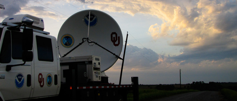
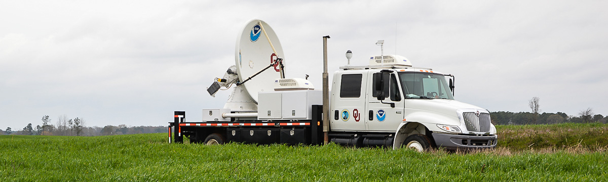
Mobile radars can be driven into position as a storm is developing to rapidly scan the atmosphere at low levels, below the beam of WSR-88D radars. NSSL has used mobile radars to study tornadoes, hurricanes, dust storms, winter storms, mountain rainfall, and even swarms of bats. NSSL researchers teamed up with several universities to build the first-ever mobile Doppler radar: a Doppler radar mounted on the back of a truck. While that radar is now operated by the University of Oklahoma, NSSL has a dual-polarized X-Band mobile radar known as NOAA X-POL (NOXP).
NOXP is a mobile Doppler radar that operates on a 3cm wavelength (X-Band). This wavelength is more sensitive to smaller particles than the longer wavelengths used by NOAA NWS radars, and is capable of detecting tiny water droplets or snowflakes.
NOXP also has dual-polarization capabilities. This means it can transmit energy pulses with both horizontal and vertical orientations, providing additional details on cloud particle shapes and precipitation size and density. This information helps enhance forecasts of precipitation amounts and can be used to improve computer predictions of thunderstorms.
Details about NOXP
- Wavelength/frequency: 3cm/X-Band/9415 Mhz
- Peak Power: 250kW
- Beamwidth: .9 degrees
- Operational range: 130 km (weather dependent)
- Deploy time: 5 minutes
Deployments
HyMeX
NOAA, NASA and the University of Connecticut represented the U.S. in the Hydrological cycle in the Mediterranean Experiment (HyMeX), the largest weather field research project in European history. HyMex is a ten-year international effort to better understand, quantify and model the hydrologic cycle in support of improved forecasts and warnings of flash floods in the Mediterranean region. During a special observation period, NSSL researchers operated a dual-polarized mobile radar in southeast France from September 10 through November 10, 2012. The radar provided high-resolution data and low altitude scans to help determine the size of the raindrops, the intensity of rainfall, and rainfall rates to help predict flash flooding conditions in the area. NSSL's participation in HyMeX is sponsored by MétéoFrance and operations are coordinated with the Cévennes-Vivarais Mediterranean Hydro-Meteorological Observatory, The University of Grenoble, NASA, University of Connecticut and Cemagraf.
Microburst and haboob prediction algorithm verification
In a ten-year cooperative research venture with the Salt River Project (SRP), an Arizona power and water utility, NSSL operates NOXP during the monsoon season near Phoenix, Ariz. to verify and improve microburst and haboob prediction algorithms.
Deep Convective Clouds and Chemistry (DC3)
The Deep Convective Clouds and Chemistry (DC3) experiment explored the role of the thunderstorm updrafts in carrying electrically charged particles, water vapor and other chemicals to the upper parts of our atmosphere. Scientists used research aircraft, mobile radars, lightning mapping arrays and other tools to make measurements that will help us understand more about the electrical and chemical structure of thunderstorms, including the concentration of ozone.
Detecting bats
Several mobile radars, including NSSL's dual-polarized mobile radar were used in a project to track swarms of millions of bats as they emerged from their caves each night to feast on insects. The radar images of bats appear as distinct “blooms.” NSSL used the data to enhance algorithms that remove the bioscatter clutter to see the weather more clearly.
VORTEX2 (2009–2010)
The Verification of the Origins of Rotation in Tornadoes Experiment (VORTEX2) was the largest field tornado research project in history. Ten mobile radars, 40 other instrumented vehicles and more than 100 scientists were deployed to collect data on supercell thunderstorms. VORTEX2 is working to better understand how, when and why some supercell thunderstorms produce tornadoes and others do not. The project was designed to observe all scales of motion from the thunderstorm down to the tornado. VORTEX2 successfully documented the lifecycle of a tornado in LaGrange, Wyoming using all of the mobile research equipment. It remains the best-sampled storm in history.
Science and NOWcasting of Olympic Weather for Vancouver (SNOW-V10)
An NSSL team deployed a dual-polarized mobile radar and a team of researchers to support the 2010 Winter Olympic Games through their participation SNOW-V10. It was a unique opportunity for international collaboration on the science of winter nowcasting in complex terrain.
Southwest Colorado Radar Project
NSSL deployed the NOXP mobile radar in southwest Colorado collect data on rain and snowfall to better forecast precipitation in mountainous areas.
Hurricane Ike
A crew from NSSL and the University of Oklahoma rode out Hurricane Ike in the cab of a mobile radar as the hurricane made landfall on the Texas coast in September 2008. It was the first time dual-polarized Doppler radar data has been collected on a landfalling hurricane eyewall. The radar was positioned near Lake Jackson, TX and collected data on Hurricane Ike from about 5 PM CDT through about 7 AM CDT. NOXP was on the edge of the western portion of the eyewall, and the maximum wind gust at their location was 84 MPH. From their position, the NOXP combined with the Houston, TX WSR-88D (HGX) radar created a dual-Doppler region that encompassed most of the western half of Ike's eye. Another mobile radar operated by the University of Alabama-Huntsville was on the north side of Houston and collected data on the eastern half of Ike's eye. Dual-polarization data was collected during the entire period. NSSL's field command vehicle and a mobile mesonet were also in Texas providing support.