
Severe Weather 101
How does hail compare to other types of frozen precipitation?
The primary difference between frozen precipitation is how the different types grow and the maximum sizes of the individual particles.
Snow forms mainly when water vapor turns to ice without going through the liquid stage. This process is called deposition. Snow can form in the gentle updrafts of stratus clouds or at high altitudes in very cold regions of a thunderstorm. Snowflakes that most of us are used to seeing are not individual snow crystals, but are actually aggregates, or collections, of snow crystals that stick or otherwise attach to each other. Aggregates can grow to very large sizes compared to individual snow crystals.
Graupel are soft, small pellets formed when supercooled water droplets (at a temperature below 32°F) freeze onto a snow crystal, a process called riming. If the riming is particularly intense, the rimed snow crystal can grow to an appreciable size, but remain less than 0.2 inches. Graupel is also called snow pellets or soft hail, as the graupel particles are particularly fragile and generally disintegrate when handled.
Sleet are small ice particles that form from the freezing of liquid water drops, such as raindrops. At ground level, sleet is only common during winter storms when snow melts as it falls and the resulting water refreezes into sleet prior to hitting the ground. In thunderstorms, sleet is possible above the melting level where cloud droplets become supercooled and may instantaneously freeze when making contact with other cloud particles or debris, such as dust particles. Sleet is also called ice pellets.
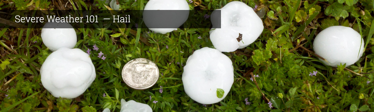
Hail is frozen precipitation that can grow to very large sizes through the collection of water that freezes onto the hailstone’s surface. Hailstones begin as embryos, which include graupel or sleet, and then grow in size. Hailstones can have a variety of shapes and include lumps and bumps that may even take the shape of small spikes. Hailstones must be at least 0.2 inches in size.
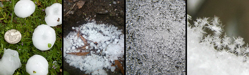
Forms of frozen precipitation. L-R: hail, graupel, sleet, snow. [+]
What we do: NSSL was a leader and major contributor to the scientific and engineering development of dual-polarized weather radar technology installed on all National Weather Service radars. Dual-polarization radar can distinguish between rain, hail, snow, or ice pellets inside the clouds.
NSSL scientists are developing algorithms that will produce estimates of whether the precipitation is reaching the ground or whether it is falling in liquid or frozen form. NSSL's Hydrometeor Classification Algorithm, or HCA, uses dual-polarization technology to automatically sort between ten types of radar echoes including big raindrops and hail. This helps the forecaster quickly assess the precipitation event and better forecast how much will fall.
NSSL's Meteorological Phenomena Identification Near the Ground (mPING) project also collects data on types of precipitation. Volunteers are invited to submit reports of what is actually falling to the ground at their location. This data is used to refine radar algorithms that detect hail and other frozen precipitation.