
Severe Weather 101
Detection of Damaging Winds
Doppler radar velocity data can show areas of diverging winds at the surface, and even the strength of those winds, indicating a downburst.
Winds coming together at midlevels of the storm, known as convergence, can also be seen on velocity displays and can indicate the development of a downburst. One of the challenges in the severe storm warning process is forecasting the initial onset of damaging winds.
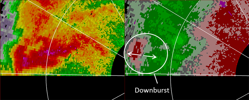
A damaging downburst event in central Oklahoma on June 14, 2011. Reflectivity data is displayed on the left with the velocity data on the right. [+]
What we do: NSSL researchers study precursor signatures with the experimental NWRT Phased Array Radar (PAR). A precursor signature develops five to 15 minutes before a downburst develops at the surface and if it can be adequately observed, could help a forecaster know a downburst is about to occur. Precursor signatures typically develop and change very quickly and rapid-update radar data is necessary to effectively utilize the signatures to anticipate downburst development. Two signatures most looked at were descending reflectivity cores and midlevel convergence, or MARC. Dual-polarization Doppler radar allows the viewing of a specific type of signature that could also be a precursor to downburst development.
In the past NSSL researchers study damaging wind events when they occur close to PAR. The ability to rapidly detect microbursts before they impact the ground is critical for aviation safety. In one case, PAR captured 29 clear images and more data during the time it took current radar to capture 6 images.
The Damaging Downburst Prediction and Detection algorithm developed at NSSL detected a moderately strong microburst in progress with winds estimated between 35–58 mph and predicted a severe microburst greater than 58 mph.
NSSL's Haboob Algorithm runs on NSSL's Multi-Radar Multi-Sensor system at Arizona's Salt River Project, and automatically monitors the radar for thunderstorms reaching thresholds that could result in outflows producing strong surface winds and blowing dust. When thresholds are reached, SRP operational personnel receive an alert to prepare for the impact of wind loading on SRP power poles and substations.