
Severe Weather 101
Lightning Basics
- What is lightning?
- Lightning is a giant spark of electricity in the atmosphere between clouds, the air, or the ground. In the early stages of development, air acts as an insulator between the positive and negative charges in the cloud and between the cloud and the ground. When the opposite charges build up enough, this insulating capacity of the air breaks down and there is a rapid discharge of electricity that we know as lightning. The flash of lightning temporarily equalizes the charged regions in the atmosphere until the opposite charges build up again.
Lightning can occur between opposite charges within the thunderstorm cloud (intra-cloud lightning) or between opposite charges in the cloud and on the ground (cloud-to-ground lightning).
Lightning is one of the oldest observed natural phenomena on earth. It can be seen in volcanic eruptions, extremely intense forest fires, surface nuclear detonations, heavy snowstorms, in large hurricanes, and obviously, thunderstorms. . - What we do: Read more about NSSL's lightning research here.
- What causes thunder?
- Lightning causes thunder! Energy from a lightning channel heats the air briefly to around 50,000 degrees Fahrenheit, much hotter than the surface of the sun. This causes the air to explode outward. The huge pressure in the initial outward shock wave decreases rapidly with increasing distance and within ten yards or so has become small enough to be perceived as the sound we call thunder.
Thunder can be heard up to 25 miles away from the lightning discharge, but the frequency of the sound changes with distance from the lightning channels that produce it, because higher frequencies are more quickly absorbed by the air. Very close to lightning, the first thunder you hear is from the closest channels,which produce a tearing sound, because that thunder contains high frequencies. A few seconds later, you hear a sharp click or loud crack from lightning channels a little farther away, and several tens of seconds later the thunder from the most distant part of a flash has quieted to low frequency rumbling.
Because light travels through the air roughly a million times faster than sound does, you can use thunder to estimate the distance to lightning. Just count the number of seconds from the time you see a flash until you hear thunder. Sound travels approximately one fifth of a mile per second or one third of a kilometer per second, so dividing the number of seconds by 5 gives the number of miles to the flash and dividing by 3 gives the number of kilometers. - Where does lightning strike?
- Most, if not all, lightning flashes produced by storms start inside the cloud. If a lightning flash is going to strike ground, a channel develops downward toward the surface. When it gets less than roughly a hundred yards of the ground, objects like trees and bushes and buildings start sending up sparks to meet it. When one of the sparks connects the downward developing channel, a huge electric current surges rapidly down the channel to the object that produced the spark. Tall objects such as trees and skyscrapers are more likely than the surrounding ground to produce one of the connecting sparks and so are more likely to be struck by lightning. Mountains also make good targets. However, this does not always mean tall objects will be struck. Lightning can strike the ground in an open field even if the tree line is close by.
- What causes lightning?
- The creation of lightning is a complicated process. We generally know what conditions are needed to produce lightning, but there is still debate about exactly how a cloud builds up electrical charges, and how lightning forms. Scientists think that the initial process for creating charge regions in thunderstorms involves small hail particles called graupel that are roughly one quarter millimeter to a few millimeters in diameter and are growing by collecting even smaller supercooled liquid droplets. When these graupel particles collide and bounce off of smaller ice particles, the graupel gains one sign of charge and the smaller ice particle gains the other sign of charge. Because the smaller ice particles rise faster in updrafts than the graupel particles, the charge on ice particles separates from the charge on graupel particles, and the charge on ice particles collects above the charge on graupel.
Laboratory studies suggest that graupel gains positive charge at temperatures a little colder than 32 degrees Fahrenheit, but gains negative charge at colder temperatures a little higher in the storm. Scientists think the two largest charge regions in most storms are caused mainly by graupel carrying negative charge in the middle of the storm and ice particles carrying gained positive charge in the upper part of the storm. However, a small positive charge region often is below the main negative charge region from graupel gaining positive charge at lower, warmer altitudes. Small ice particles that have collided with negative graupel in the lower region can contribute positive charge to the middle of the storm.
A conceptual model shows the electrical charge distribution inside deep convection (thunderstorms), developed by NSSL and university scientists. In the main updraft (in and above the red arrow), there are four main charge regions. In the convective region but outside the outdraft (in and above the blue arrow), there are more than four charge regions.
You can read more about lightning at the NOAA's JetStream Online School for Weather. - How is electrical charge distributed through a thunderstorm?
-
A conceptual model shows the electrical charge distribution inside deep convection (thunderstorms), developed by NSSL and university scientists. In the main updraft (in and above the red arrow), there are four main charge regions. In the convective region but outside the outdraft (in and above the blue arrow), there are more than four charge regions.
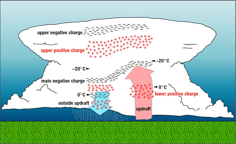
Charge distribution in storm clouds [+]
What we do: NSSL researchers use a 3-D cloud model to investigate the full life-cycle of thunderstorms. The model has shown how graupel or other droplets could help form regions of lower charge within the storm.
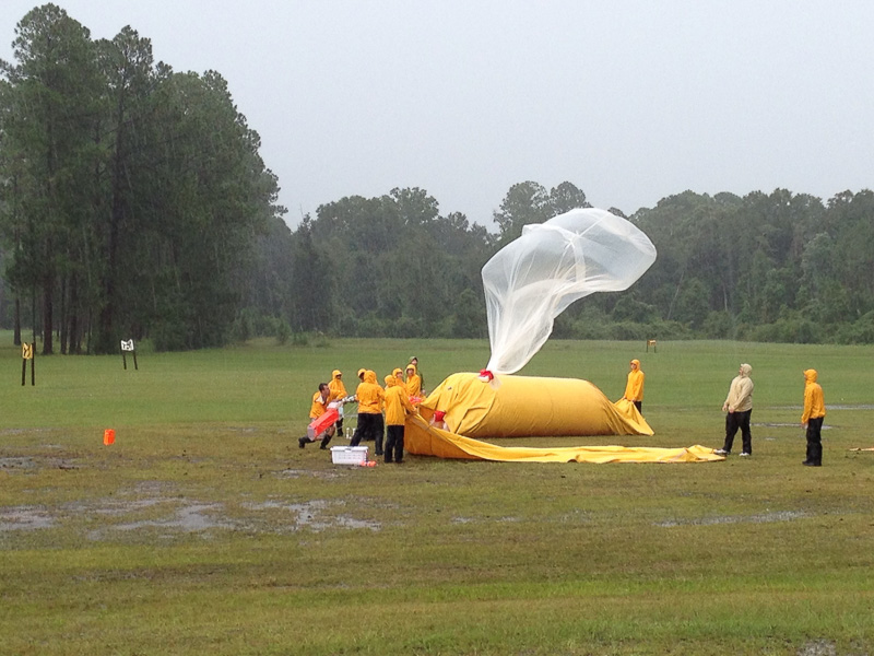
NSSL team launches an instrumented weather balloon to study lightning in northern Florida. [+]
NSSL researchers were pioneers in the science of launching instrumented weather balloons into thunderstorms. This capability allowed NSSL to collect weather data in the vicinity of tornadoes and drylines, and all the way up through a thunderstorm, gathering critically needed observations in the near-storm environment of thunderstorms. In addition, these mobile labs and ballooning systems provided the first vertical profiles of electric fields inside a thunderstorm leading to a new conceptual model of electrical structures within convective storms.
One way researchers test their theories is by making measurements of severe thunderstorms in the field and later analyzing the results. Large-scale field experiments involving many instruments with a primary focus on atmospheric electricity include the Deep Convective Clouds and Chemistry experiment (DC3), the MCS Electrification and Polarimetric Radar Study, the Severe Thunderstorm Electrification and Precipitation Study and the Thunderstorm Electrification and Lightning EXperiment.