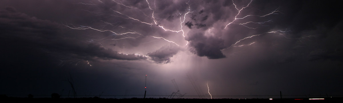
NSSL Research: Lightning
NOAA National Severe Storms Laboratory researchers have studied lightning for almost half a century. We continue to learn more about lightning structure and behavior while developing methods to use lightning data to improve severe weather forecasts and warnings.
Oklahoma lightning Mapping Array (OKLMA)
The Oklahoma Lightning Mapping Array (OKLMA) provides three-dimensional mapping of lightning channel segments over Oklahoma. Thousands of points can be mapped for an individual lightning flash to reveal its location and the development of its structure. This data shows where lightning initiates in a storm, where the storm is carrying net charge, and how large of an area a flash covers. NSSL is investigating how lightning characteristics relate to updrafts, precipitation, and severe storm processes.
Satellite Lightning Detection
The Geostationary Operational Environmental Satellite-R Series (GOES-R) is the current generation of geostationary weather satellites. The first GOES-R satellite, GOES-16, which covers the eastern half of the United States, was launched in 2016. GOES-17 covers the western half and was launched in 2018. These satellites are each equipped with a Geostationary Lightning Mapper (GLM) that detects the light emissions from both cloud-to-ground and inter-cloud lightning which escape the cloud and make it to space. This technology helps severe weather forecasters identify rapidly intensifying thunderstorms so they can issue accurate and timely severe thunderstorm and tornado warnings.
The GLM also provides a brand new, constant monitor of lightning over a large area that scientists at NSSL and elsewhere can use to address research questions we were not able to address before. How does the total lightning in a hurricane rain band change as it makes landfall? Can we use lightning to improve our weather forecast models? How far can a single lightning flash travel? The previous record recognized by the World Meteorological Organization was 321 km (199 miles) long and was observed by the Oklahoma Lightning Mapping Array (OKLMA) in 2007. But, the GLM can monitor a much larger area than the OKLMA. This record was broken in 2020 by a flash 709 km (441 mi) long observed with the GLM over South America!
One thing to consider with a brand new instrument is that there are also brand new things to learn about what it sees. Does the GLM see the same signatures of a strong updraft that we observed with an LMA? What flashes can it not measure because not enough light made it out of the cloud to space? If light from the lightning doesn't make it out of the cloud, does that mean that bulky raindrops and hailstones prevented the light from escaping? Could this be a way to monitor the presence of hail in the cloud?
The Pseudo-Geostationary Lightning Mapper (PGLM) was the primary lightning training tool for the GOES-R program in preparation for the launch of the GLM. The PGLM used total lightning data from three Lightning Mapping Array (LMA) networks including the Oklahoma Lightning Mapping Array (OKLMA) and the Lightning Detection and Ranging network that detects radio waves emitted in the very high frequency range by lightning flashes. Flashes were sorted, and a Flash Extent Density product was created to approximate the resolution of the GLM. The PGLM tool was used to start development of forecasting applications using the GLM before the satellite was launched. It and other data collected by LMAs remain useful, especially in determining how GLM measurements compare to ground measurements, and determining what new GLM measurements can and cannot see.
Lightning Behavior
How ice particles grow and move around in a storm controls where lightning flashes happen and how large those flashes become. NSSL researchers study lightning mapping data to learn how lightning behavior can be associated with different types of storms, and what the lightning may tell us about other processes happening within the storm. Lightning mapping has shown that some supercell thunderstorms have “lightning holes” where updrafts are located and precipitation is scarce, sometimes appearing just before a storm becomes severe. This information could alert forecasters about developing severe conditions. It has also shown that near the updrafts of thunderstorms flashes tend to be smaller, which can be useful for forecasters in quickly pinpointing portions of storm complexes that need to be monitored. Lightning mapping also shows changes in flash altitudes throughout a storm’s lifecycle, and can even show overshooting top signatures in deep thunderstorms!
We have shown that rapid increases in total lightning activity are often observed tens of minutes in advance of severe weather occurring at the ground. These rapid increases in lightning activity have been termed “lightning jumps.” An operationally applicable lightning jump algorithm was developed with the total lightning observations made from lightning mapping arrays. Combined with the other features that exist in the total lightning data, this is an additional indicator for forecasters to look at to monitor a storm.
Predicting Lightning And Using Lightning to Predict Storms
Lightning is dangerous to people outside or without good shelter, so predicting areas at risk of lightning strikes can be useful for outdoor activities. NSSL scientists are working on two tools, both tools use machine learning to help predict whether lightning is likely at a given location. The first one is the experimental Lightning Probabilistic Hazard Information (PHI) tool. This tool incorporates data on current storms and past observations to continuously predict the probability of cloud-to-ground lightning strikes in the next hour. The second is testing whether we can use weather forecast model output from the NSSL Experimental Warn-on-Forecast System to help us predict the probability of significant rates of cloud-to-ground lightning hours in advance.
Find out more about lightning prediction at: https://www.nssl.noaa.gov/education/svrwx101/lightning/forecasting/
NSSL scientists are also researching if lightning activity can help us predict what storms will do in the future. Increases in flash rates can signify a strengthening storm in the near future, which is useful for forecasters monitoring storms. For looking at storm behavior farther into the future, lightning can be used in conjunction with radar data to give a computer model more information on the initial conditions of the atmosphere and the storms that are already present. NSSL researchers have collaborated with other universities and agencies to test different ways of incorporating Geostationary Lightning Mapper information into forecast models, a technique known as data assimilation.
The NOAA Hazardous Weather Testbed (HWT) is important for each of these topics. In the HWT, NSSL partners with the NWS Storm Prediction Center and the National Weather Service to develop, test, and evaluate new observations such as those from the GLM and severe weather forecasting techniques for the entire United States. A cornerstone of the HWT is the Spring Experiment, held each year during the active spring severe weather season. The exchange provides forecasters with a first-hand look at the latest research concepts and products, while research scientists gain a valuable understanding of the challenges, needs, and constraints of front-line forecasters which can better direct future research performed at NSSL.
Lightning Simulations
NSSL/CIWRO scientists simulated realistic cloud-to-ground lightning flashes for the first time using a 3-D cloud model that generates complex precipitation such as graupel (soft hail), which is known to affect lightning production. Scientists use the model to simulate the updraft, cloud, and precipitation structure in supercell storms that produce the OKLMA-observed “lightning holes.” They also use the model to make comparisons between simulated and observed flashes and analyze lightning more closely. Some of these processes have been added to the widely-used Weather Research and Forecasting (WRF) model to make explicit forecasts of storm electrification and estimate lightning occurrence. These simulations are used for studying how lightning responds to other factors in isolation: How does the aerosol content affect the amount and type of lightning produced? How does that compare to changes in the environment?
COMMAS model output: This animation shows cloud edge (gray), 40 dbZ volume (brown), vertical vorticity (blue), lightning (white and yellow volumes), and surface simulated radar reflectivity and wind vectors. (Note: no audio track, no captioning.)
Lightning Field Equipment
Oklahoma Lightning Mapping Array
In 2020–2021, NSSL researchers installed a full network of Lightning Mapping Array (LMA) sensors on portable, solar-powered platforms. This mobile network will be used to study lightning outside of the existing Oklahoma Lightning Mapping Array (OKLMA) domain in conjunction with other field projects, such as VORTEX-SE in 2022. Like the OKLMA, the mobile LMA network can be used to study the full three-dimensional structure of lightning flashes inside storms, including where flashes initiate, how large of an area they propagate through, the length of time it takes for lightning to develop, where net positive and negative charge collects in the cloud, and estimate the electrical energy dissipated by each flash.
Mobile Ballooning Facility
In the 1980s, NSSL researchers modified a 15-passenger van by mounting a Cross-Chain Loran Atmospheric Sounding System inside and invented a high-wind launch device for releasing helium-filled balloons in very high winds. The vans were replaced by modified ambulance-style vehicles, which are rarely used in the field.
This pioneering capability allowed NSSL to collect data in the vicinity of tornadoes and drylines, gathering critically needed observations in the near-storm environment of thunderstorms. In addition, these mobile labs and ballooning systems provided the first vertical profiles of electric fields inside a thunderstorm leading to a new conceptual model of electrical structures within convective storms. Larger instruments needed larger balloons (and more helium) to carry them. Moving vans have also been outfitted for field programs to carry helium tanks and pre-inflated balloons to the thunderstorm.
Balloon-borne Instruments
The NSSL Field Observing Facilities and Support group (FOFS) built a special balloon-borne instrument called a PArticle Size, Image, and Velocity probe (PASIV), designed to capture high-definition images of water and ice particles as it is launched into, and rises up through a thunderstorm. The instrument is flown as part of a “train” of other instruments connected one after another to a balloon. One important instrument for lightning research attached to these balloons is an electric field meter, which measures the electric field strength and direction (this has been used to verify remote estimations of charge made with the OKLMA). Additional instruments measure other atmospheric variables such as temperature, dewpoint, pressure, and winds. Data from these systems helps researchers understand the relationships between the many macro and microphysical properties in thunderstorms such as where different precipitation particles and electrically charged regions are present in the storm. This information is used to help evaluate theories on thunderstorm electrification and lightning production.
Lightning Field Projects
DC3
The Deep Convective Clouds and Chemistry (DC3) field experiment (2012) used aircraft and ground-based instruments to investigate thunderstorms. This project studied how thunderstorm updrafts carry electrically charged particles, water vapor, and other chemicals (including those created by lightning such as NOx) to other parts of the atmosphere.
TELEX
TELEX, the Thunderstorm Electrification and Lightning EXperiment (2004-2005) studied how lighting and other electrical storm properties are dependent on storm structure, updrafts, and precipitation.
STEPS
STEPS (2000), the Severe Thunderstorm Electrification and Precipitation Study, made meteorological and electrical observations of supercell thunderstorms
MEaPRS
MEaPRS, the MCS Electrification and Polarimetric Radar Study (1998), investigated polarization radar signatures and electrification processes in Mesoscale Convective Systems.
Storm Electricity Research Partnerships
NSSL works with NASA's Short-term Prediction Research and Transition (SPoRT), the Cooperative Institute for Meteorological Satellite Studies (CIMSS), New Mexico Institute of Mining and Technology (NMIMT), the Cooperative Institute for Research in the Atmosphere (CIRA) and the NOAA National Environmental Satellite, Data and Information Center (NESDIS), in addition to working closely with the NOAA Storm Prediction Center (SPC) and the NOAA National Weather Service (NWS).
Lightning Safety
NSSL researchers actively promote lightning safety education and serve on the National Lightning Safety Council. NSSL researchers have studied how close is “too close” for lightning. They found that 80% of the next lightning strikes in a storm are within two to three miles of each other in certain weather conditions in Florida, but more typically lightning strikes are about six miles from each other. Their research was incorporated into a paper on updated recommendations for lightning safety. They designed posters about the dangers of taking shelter under trees, and more than 16,000 copies were distributed to teachers, NWS staff, and others. NSSL researchers provided valuable input to the NCAA Committee on Competitive Safeguards and Medical Aspects of Sports as they developed guidelines for lightning safety at NCAA sporting events. They also helped create a position statement regarding lightning safety for athletics and recreation for the National Athletic Trainers' Association.
Other Research
The Electrical Nature of Storms (1998)
NSSL's Don MacGorman and Dave Rust wrote The Electrical Nature of Storms, a textbook discussion of atmospheric electricity and the electrical processes that occur in storms.
Principles of Lightning Physics (2016)
Written by physicist Vladislav Mazur, based on his more than 30 year career at NSSL, Principles of Lightning Physics presents and discusses the most up-to-date physical concepts that govern many lightning events in nature, including lightning interactions with man-made structures.
Climatology
NSSL scientists have reported on the climatologies of lightning in different states including AZ, FL, GA, SC, NM, KS, CO, and OK.
WSR-88D
NSSL worked with the NWS to carefully evaluate the performance on the WSR-88D lightning protection system and make recommendations for improvement. Part of the process included creating a 3-D computer simulation of cloud-to-ground lightning striking a radar antenna tower.