Research Tools: Dual Polarized Radar
Dual-polarization (dual-pol) radar technology is truly a NOAA-wide accomplishment. The NOAA National Severe Storms Laboratory spent nearly 30 years researching and developing the technology. Dual-pol is the most significant enhancement ever made to the nation's radar network since Doppler radar was first installed in the early 1990s.The NOAA National Weather Service (NWS) and NSSL developed the specifications for modifications to the single-polarization WSR-88D radars. The upgrade was tested by engineers at the NWS Radar Operations Center and such tests decided the practicality of upgrading the nationwide network of Doppler radars.
Bite-Sized Science: Dual Polarization Technology
A quick glance at the new dual polarization technology added to the national weather radar network. Watch on YouTube
History
In 2002-2003, NSSL conducted the Joint Polarization Experiment (JPOLE) to demonstrate the operational capabilities of the prototype dual-pol WSR-88D radar. During JPOLE, NSSL scientists aided in data interpretation as it was delivered in “real-time” to NWS forecasters and other users. JPOLE proved that significant improvements in rainfall estimation, precipitation classification, data quality and weather hazard detection were possible using polarimetric radar and provided supporting evidence for upgrading the entire NEXRAD fleet to dual-pol capabilities. Since the completion of the upgrade to dual-pol, the NOAA NWS Warning Decision Training Division has provided timely and relevant training to all NWS forecasters who use the technology.
The upgraded radars offer 14 new radar products to better determine the type of precipitation, the intensity and how much precipitation may fall; in addition to confirming if a damaging tornado is occurring during a storm. The upgraded radars also help tell the difference between smoke, birds, bats and bugs.
Radar Basics
Radars send out short pulses, also known as bursts, of electromagnetic energy. Some of this energy is scattered by particles or objects in the atmosphere and returns back to the radar antenna. A computer processes the returned signals and, through algorithms, can identify kinds of particles the radar “saw,” including how quickly the particles are moving toward or away from the radar (i.e., the Doppler effect).
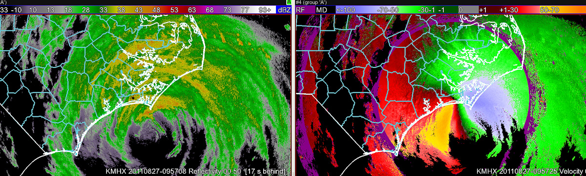
Single-polarization Doppler radars, including the NOAA radars before the dual-polarization upgrade, typically transmit horizontally polarized electromagnetic waves, which only give a measure of the horizontal dimension of precipitation particles, like snow, ice pellets, hail and rain. This one-dimensional picture makes it difficult to tell the difference between precipitation types.
Dual-Pol Technology
With dual-pol technology, the picture becomes two-dimensional because the radar sends both horizontally and vertically polarized electromagnetic waves. As these perpendicular fields scatter, or “bounce,” off of an object and are received back at the radar, a computer program processes information about the horizontal and vertical properties of the particles. For example, the corresponding cross-sections give forecasters a measure of the size and shape of the object, which can be used to infer more information about the types of objects that scattered the waves, like whether the radar is observing rain or snow, or big raindrops versus small raindrops. Moreover, the correlation between the two returns is very different in cases of precipitation compared to non-precipitation returns.
Current Research
Dual-pol researchers at NSSL are endeavoring to:
- Improve a dual-pol “hydrometeor classification algorithm” that combines dual-pol radar observations with temperature information from numerical weather prediction models to determine what type of precipitation is being observed.
- Identify consistent and/or reliable dual-pol signatures associated with various precipitation processes in winter storms, such as the formation of ice pellets or large snowflakes.
- Examine dual-pol signatures that can help NWS forecasters anticipate the development of hazardous weather such as large hail and downbursts.
- Develop approaches for incorporating information inferred from dual-pol radar about the observed precipitation back into numerical weather prediction models.
- Examine the performance of a dual-pol partial beam blockage correction algorithm on radar quantitative precipitation estimation,
- Examine impacts of dual-pol radar observations on hydrologic simulations to better predict excessive rainfall and flooding.
- Determine specifications for a dual-pol Phased Array Radar (PAR) and evaluate various design issues.
- Test and evaluate dual-pol PAR prototypes.
The Benefits of dual-polarization radar
Dual-pol radar provides measurable benefits to a variety of users:
Meteorologists
- Can help identify large hail and tornadic debris on radar displays, improving severe thunderstorm and tornado warnings.
- Can identify thunderstorm updraft locations and intensities.
- Can give more information about the microphysical processes in storms, which can help improve numerical weather prediction models and quantify results of satellite measurements.
- Can identify types of winter precipitation, like snow, thus improving forecasts of liquid water equivalent or snow depth.
- Can separate non-weather scatterers, such as bugs and birds, from meteorological data.
Hydrologists
- Can differentiate hail from rain and significantly improve the accuracy of radar-estimated rainfall, which is critical for forecasts of flash floods, river flooding, and for water management.
- May contribute to increased lead time for flash flood warnings.
Aviation users
- Detects aviation hazards such as birds.
- Can detect aircraft icing conditions.
- Can identify regions of large and giant hail.
- Can help increase confidence in detecting regions where dangerous downbursts may occur.
Society
- Has the potential to save the public about $700 million annually by improving precipitation estimation.
- Can improve forecasts, warnings and reduce the impact of hazardous weather on our national transportation systems.
- Better equips NWS forecasters to issue accurate warnings, and in turn helps the public to make wiser decisions about its safety.