Warn-on-Forecast
Case Studies Using the Warn-on-Forecast System
The Purpose of Case Studies
Case studies describe how a weather event came together, what it looked like during its peak, and will sometimes describe how it ended. Common elements of case studies include the meteorological “setup,” or an overview of what ingredients were present in the atmosphere, radar and satellite data and model output that tell the story of the event, and a summary of damages or noteworthy measurements such as record rainfall. While most research projects will also include objective data analysis, case studies can be a nice complement, helping illustrate how new tools or techniques can be useful in real-world situations. They can also reveal which parts of a tool need to be further developed before becoming useful.
Below we will present a number of case studies for WoFS. These will focus on the variety of information, and especially probabilistic information, that is available from WoFS, as well as giving a broad sense of how WoFS can be used to improve warnings for many different types of severe weather.
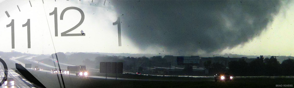
Tornadoes
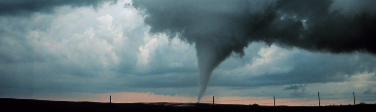
A major goal of the Warn-on-Forecast project is to improve lead time for tornado warnings. With Doppler radar and spotter reports as the main resources for forecasters deciding when to issue a warning, lead time has leveled off at around 13 minutes, on average. Having a model system like WoFS, which uses radar and other observations to project individual city-sized thunderstorms out several hours in time, may allow forecasters to warn earlier based on the forecast. This may be especially true for the most intense, classic supercell storms that produce the most dangerous tornadoes. Thus far, the resolution of WoFS is not quite high enough to predict individual tornadoes, but WoFS does predict strong rotation within individual thunderstorms, and this can act as the model equivalent of a tornado forecast when combined with other information. We have begun to see real-world examples of WoFS prompting a National Weather Service Office to ramp up the expectations they are feeding to media and other partners, and to issue statements predicting where tornado warnings are likely to be needed. In other cases, researchers looking at past events can pick out clues in WoFS that will give forecasters an idea of what to look for next time. Click to read the example case studies below.
- Nocturnal Strong to Violent Tornadoes at Nashville and Cookeville, TN, March 2-3, 2020
- WoFS influences lead time on the damaging and deadly Elk City, OK, tornado, May 16, 2017
Large Hail

Large and damaging hail often occurs in tandem with tornadoes or the threat of tornadoes. At other times, the ingredients are not very favorable for tornadoes, making large hail the primary hazard. On days where the moisture, instability, and wind shear in the atmosphere suggest that large hail is likely, the challenge is being able to predict where individual storms will develop, and whether they will maximize their hail potential by rotating and remaining isolated. Characteristics like rotating versus non rotating, isolated versus clustered, and long-lived versus short-lived are known as “storm mode.” During experimental real-time runs, WoFS has often provided accurate predictions of storm mode, sometimes helping forecasters anticipate large hail. Note that these early experimental results are mainly from the Great Plains, but hail storms such as these also occur in the Midwest, Ohio Valley, and Southeast, and can occasionally occur elsewhere up the East Coast. Click below for examples of WoFS being used for hail prediction.
Damaging Straight-line Winds
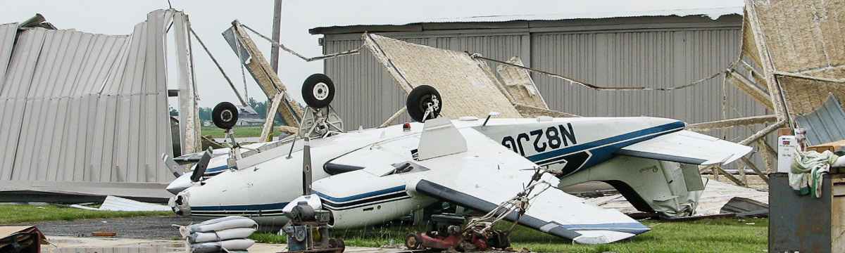
Most thunderstorms produce windy downdrafts where air is exiting the storm, and many times these winds become severe, either causing considerable damage or peaking above 58mph. In extreme cases thunderstorm winds have been known to peak above 100mph or even 120mph. That is equivalent to a Category 2 or 3 hurricane! So predicting damaging straight-line winds is an important job. Unfortunately, Doppler radar does not offer many heads-up clues. The strongest winds are usually already occurring at the ground by the time they return compelling signals to the radar. This is where it is hoped that WoFS can help by giving forecasters earlier, rapidly-updating signals that can help identify when and where damaging winds are likely to form. Look below for case studies of a variety of damaging wind storms.
Typical Severe Wind Events
Often reports of damaging winds are scattered among reports of other types of severe weather like hail and tornadoes, with all these hazards occurring simultaneously. Sometimes thunderstorms spend a few hours remaining isolated from each other and producing more hail and tornadoes, followed by a period of time when the storms merge together and severe winds become the main threat. These two scenarios describe the majority of what could be considered “typical” severe wind events. See examples below.
- Alabama, May 4, 2021
Derechos
Derechos are large, long-lived thunderstorm systems with unusually intense and persistent winds. They are somewhat rare, and may not occur every year, but when they do occur they immediately become memorable for the amount of damage they inflict on forests, crops, and human-built infrastructure. WoFS case studies of derechos are linked below, including the tremendous derecho that struck Iowa and continued on toward Chicago in August of 2020.
- The Iowa Derecho, August 10, 2020
(This is the costliest thunderstorm event on record) - Wisconsin “Blowdown” Derecho, July 19, 2019
- North Dakota Derecho, June 28, 2018
See the Storm Prediction Center’s page for more information on derechos.
Winds That Form as Storms Weaken
One of the early unexpected benefits we are discovering from WoFS is the ability of the model system to predict damaging winds in areas where strong thunderstorms no longer exist. These winds can happen for several reasons. One is that a storm cloud has recently collapsed, so it has sent a rush of air toward the ground and yet the cloud has disappeared so that radar has no storm there to detect. Another is that water and ice are falling through drier air above the ground, and cooling that takes place as the precipitation evaporates causes that air to become more dense - also rushing toward the ground. These events happen several times each year, and yet they can catch forecasters by surprise, especially when the forecasters are focusing their attention on other areas where radar does show strong thunderstorms. We have seen enough early success using WoFS to catch these wind events that this is quickly becoming one of the characteristic features of WoFS. Click the case study links below.
- Oklahoma “Wake Low” Event, May 14, 2020
Flash Flooding
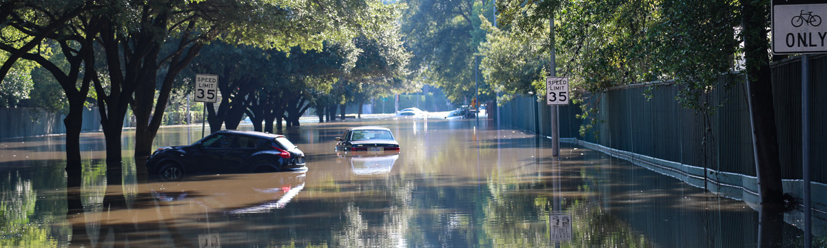
The very same thunderstorms that produce tornadoes, hail, and strong winds, also produce heavy rain that leads to flash flooding. Sometimes all of these hazards can occur simultaneously in different storms across a particular state or region of the country, and at other times the storms may begin as severe weather producers before transitioning almost entirely to a flash flood threat as they congeal. It is not surprising then, that while WoFS was developed to predict severe weather, it has also provided effective guidance for identifying flash flood events.
In 2018 through 2020, the WoFS research group conducted a project with NOAA’s Weather Prediction Center (WPC) to test WoFS during flash floods. While the emphasis for severe weather prediction is in the spring, flash flooding peaks during the summer, a time at which thunderstorm systems become harder to predict owing to weaker steering winds and highly variable storm mode. The WPC research helped expand WoFS use to other parts of the U.S., such as New England and the desert Southwest, where springtime severe weather is less of an issue. The project also gave us data on a number of landfalling tropical cyclones, each with their own unique severe weather and flash flood prediction challenges.
The following are a few examples of WoFS being applied to flash flood forecasting:
Monsoon
The North American monsoon is a unique season in which scattered daily thunderstorms become a regular occurrence in the semi-arid Southwest United States. These storms often produce flash flooding and damaging winds, along with frequent cloud-to-ground lightning. Thunderstorms over the Southwest usually experience weak steering winds, weak inflow at the bottom of the cloud, and local mountain effects that are difficult to study. All of this can yield interesting and unexpected thunderstorm behavior. Researchers are interested in studying how WoFS can help forecasters in the Southwest with the monsoon. In July 2021, the WoFS group captured a handful of active monsoon days; see the case studies below.
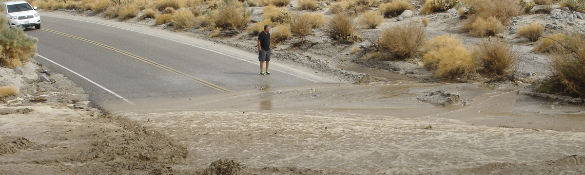
- Flash Flooding at Flagstaff, AZ, July 14, 2021
Tropical Cyclones
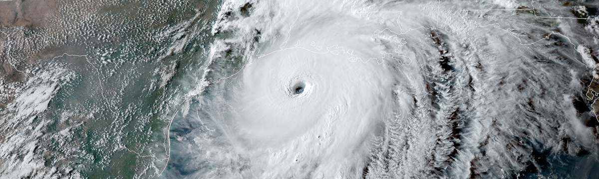
Tropical cyclones (meaning Tropical Storms or Hurricanes) are another unique weather event in which researchers are interested to see how WoFS performs, and what value it can add to the forecast process when storms move inland. These last few years have seen numerous tropical cyclones make landfall in the contiguous United States. Early studies of these storms show that WoFS has done a good job forecasting the location and intensity of intense rainfall, and forecasting rotation in individual thunderstorms that circulate around the cyclone. WoFS has also shown the potential for forecasting landfalling tropical cyclone eyewall wind speeds along the coast and after the eye is fully inland. Some example WoFS data for tropical cyclone events is included below.
- Hurricane Ida, September 1–2, 2021
- Hurricane Laura, October 9, 2020
- Hurricane Sally, September 15–16, 2020