
NSSL’s Grand Scientific Challenges
NSSL’s science strategy is built around six grand scientific challenges, followed by a strategy to improve the workplace itself. These grand challenges represent problems that will be difficult to address but will have substantial or even game-changing impacts. Here we identify what the challenge is, and why it is important, and how we will address it.
GSC 1: Develop reliable probabilistic guidance products
The improving skill of numerical models (particularly convective resolving model improvements and ensemble based probabilistic forecasts) combined with emerging model post-processing techniques and model diagnostic tools, will be the dominant source of better weather information for the NWS during the next decade. In addition, the assimilation of higher resolution satellite-derived data sets in the GOES-R era will enhance the accuracy, reliability, and value of model output information for a broad spectrum of forecasting services. NSSL will develop reliable probabilistic guidance products for prediction of the development and evolution of severe convection, including intensity changes, storm interactions, upscale growth, and attendant societal impacts. We aim to attain the goal of the Warn-on-Forecast (WoF) program to provide NWS forecasters with the probabilistic guidance needed to extend lead-times for severe thunderstorm and tornado warnings out to one hour with reduced false alarms. NSSL plans to develop and implement into operations a convection-allowing atmospheric ensemble prediction system (EPS) using advanced data assimilation and improved model physics to predict individual thunderstorm character and interactions. In parallel, we will build a prototype sub-kilometer resolution numerical simulation system to improve understanding of the atmospheric processes at work for tornado-cyclone scale phenomena and their representation in numerical models.
Read more about... NSSL forecast tool development · NSSL warning tool development
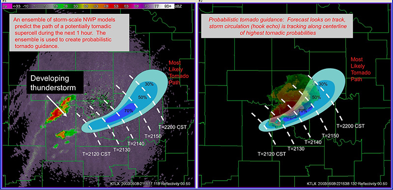
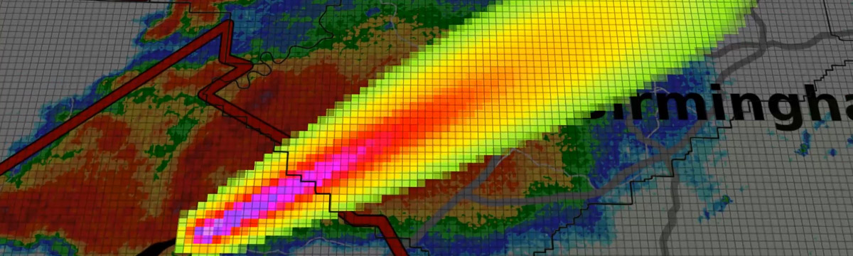
Left: An ensemble of storm-scale NWP models predicts the path of a potentially tornadic supercell during the next hour. The ensemble is used to create probabilistic tornado guidance.
Right: Probabilistic tornado guidance: Forecast look on track, storm circulation (hook echo) is tracking along centerline of highest tornadic probabilities [+]
Right: Probabilistic tornado guidance: Forecast look on track, storm circulation (hook echo) is tracking along centerline of highest tornadic probabilities
GSC 2: Produce enhanced capabilities for WSR-88D
NSSL will produce enhanced capabilities for WSR-88D radars to continue to meet evolving requirements through its end-of-life, and also develop radar replacement technologies leading to an NWS acquisition/deployment program by 2030. It is necessary to enhance WSR-88D utility while addressing this aging operational radar technology, current gaps in radar coverage, and longstanding limits of 14-minute average tornado lead time with ~75% false alarm rates. NSSL will build and assess phased array radar technologies with dual-polarization capability, assess gap-filling strategies, and design advanced radar signal processing to optimize radar advancements. We will also work on breakthrough methods for dual polarization data assimilation for better microphysical representation in multi-phase hydrometeor environments, and improved algorithms to derive geophysical variables (e.g., hydrometeor classification) with greater accuracy.
GSC 3: Reliably predict flash flooding

NSSL intends to demonstrate the capability to reliably predict flash flooding for both urban and complex landscapes several hours in advance, providing a probabilistic hydrologic prediction with much longer lead time and more accurate prediction than current systems. Municipal and emergency response officials need this capability since flash floods remain the number one hazardous weather-related killer in the U.S. We will leverage advances in convection-allowing EPSs and in Multi-Radar Multi-Sensor (MRMS) operations to initialize ensemble models for surface hydrology, inundation, and landslides. Probabilistic precipitation forecasts from the EPSs will be used to drive the hydrology models hours in advance of an event, and these models would be frequently updated with precipitation estimates from MRMS as an event begins. The quality of the EPS forecasts depends upon advances made in basic research to better understand processes leading to storm intensification.
Read more about... NSSL flooding research
GSC 4: Predict useful warnings of lightning activity one hour in advance

NSSL aspires to predict useful warnings of lightning activity one hour in advance from the very onset of convection to its demise, both in-cloud (as an indicator of storm intensity changes and short-term predictor of severe weather potential) and cloud-to-ground lightning (for public safety purposes). Accurate short-term prediction of lightning activity is needed to improve public safety (Weather Ready Nation), and to address aviation concerns for ground operations and warning of possible lightning strikes to aircraft in terminal areas (cloud-to-ground lightning). Our approach consists of integrating data from radar, ground-based lightning mapping systems, and geostationary satellite sensor systems into very short-range numerical weather prediction models. We will also conduct basic research to understand and hence improve representation of microphysical processes and electrification processes in numerical models that include lightning production.
Read more about... NSSL lightning research
GSC 5: Develop reliable nowcasting system for convection initiation
Another goal is to develop a reliable nowcasting system for convection initiation that goes well beyond the current reliance on surface, radar and satellite detection of low-level boundaries. We need to address fundamental gaps in our understanding of how the pre-convective environment is evolving in terms of available moisture, instability, wind shear, and storm generation mechanisms. NSSL will develop and field test innovative new atmospheric observing systems and use this data in conjunction with Observing System Simulation Experiments (OSSE) to determine the optimal design of a mesoscale observing system composed of Unmanned Aircraft Systems (UAS), and ground-based and satellite remote sensing systems, to meet the need to provide short-term forecasts of if, where, when, and what type of deep convection will develop. We will also continue basic research on atmospheric processes responsible for convection initiation and assimilation systems to take advantage of these new data.
GSC 6: Provide and communicate warning uncertainty information for high impact weather events
NSSL will provide uncertainty information for high impact weather with the goal of reducing tornado and other severe weather warning false alarms by at least 30%, and produce probabilistic, risk-based information to complement current “binary” yes/no warning areas. This will support improved public decision-making required for a better-informed Weather-Ready Nation that is resilient to dangerous, high-impact weather events. NSSL will integrate MRMS, advanced observational systems, social science, and other innovations into future development of FACETs (Forecasting a Continuum of Environmental Threats), a next-generation hazardous weather watch/warning paradigm built on the concept of a continuous stream of high-resolution, probabilistic hazard information. FACETs will also help the NWS provide greater consistency of products and services associated with the severe weather warning process, through the development of situational awareness visualizations and decision support tools. We will also perform basic research on how to best represent probabilistic, grid-based information to the decision maker, how best to communicate probabilistic results to different constituencies to obtain the desired response, and other social science areas of research.