
Warn-on-Forecast Case Studies
Flash flood event at Leesburg, VA, Aug 6, 2020
Events over the mid Atlantic on August 6, 2020, give a prime example of the difficulties inherent in forecasting thunderstorms and their hazards, and the kind of event where WoFS can help provide critical clues at just the right time. That afternoon and evening there were numerous clusters and lines of thunderstorms, and a few short-lived supercells, the bulk of which occurred in central Virginia. Other smaller clusters of thunderstorms occurred from northern Virginia through western Maryland. National Weather Service outlooks had predicted a Slight Risk of excessive rainfall and a Marginal Risk of severe weather over this region, certainly good forecasts. The harder question to answer is whether any of the dozens of thunderstorms on a day like this will produce local weather that becomes exceptionally severe, or overlaps with population centers in a way that would enhance the risk to life and property. On many days in the summer, it is not even clear whether the greatest threat is from severe winds or flash flooding. As it turned out on this particular day the most impactful thunderstorm cluster was one that remained stationary for several hours and produced significant flash flooding in the city of Leesburg, Virginia.
WoFS was run in real-time on August 6, 2020. Forecasters at the NOAA Weather Prediction Center used the data as part of an ongoing project with the WoFS group. The local NWS office in Sterling, Virginia, reported that they, too, had found WoFS useful when dealing with the Leesburg flash flood. Below are a few images that help tell the story of the WoFS run that day.
Meteorological Setup
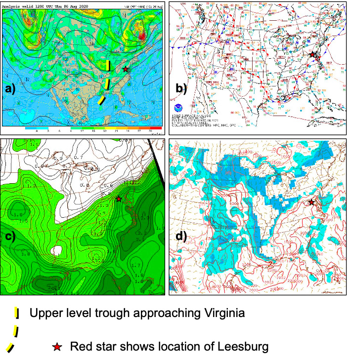
(a) Upper level (500 mb) map Thursday morning
(b) Weather Prediction Center surface analysis, Thursday midday
(c) Atmospheric moisture (precipitable water) available to any existing thunderstorms
(d) Instability available to any existing thunderstorms, showing moderate values (1000 to 2000) over Virginia [+]
(b) Weather Prediction Center surface analysis, Thursday midday
(c) Atmospheric moisture (precipitable water) available to any existing thunderstorms
(d) Instability available to any existing thunderstorms, showing moderate values (1000 to 2000) over Virginia
These maps show snapshots of weather conditions on August 6, 2020, ranging in time from morning to mid afternoon, all prior to thunderstorm development. The mid Atlantic region was downstream of an approaching upper-level trough, and located to the cool side of a wavy frontal boundary. Being in this location can lead to enhanced lifting from the approaching trough, as well as from light easterly winds causing air to rise up into the mountain areas in Virginia and western Maryland. The available moisture and instability were sufficient to support both a severe weather and flash food risk.
The Storm Occurring at Leesburg, VA
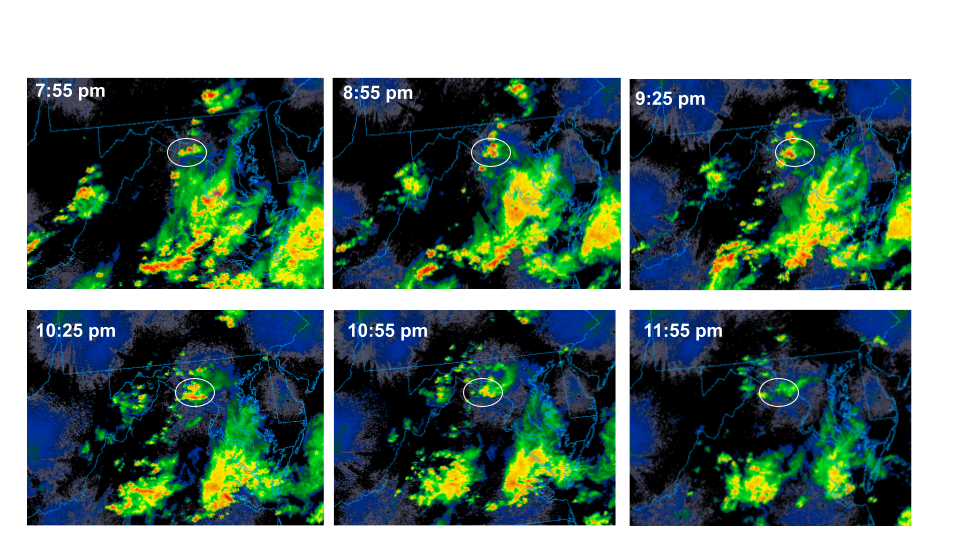
This sequence of images shows observed regional radar with a domain stretching from southern Virginia to southern Pennsylvania. These individual radar images, which are spaced out at 30 to 60 minutes between each image, show that the storm cluster over Leesburg, VA, persisted for several hours, producing very heavy rain (imagery courtesy of UCAR).
WoFS Loop
This is a loop of one full run of WoFS valid from 7:00pm EDT to 1:00am EDT. The color-filled image shows the predicted rainfall as it accumulates throughout the model run. Note that each WoFS member produces its own rainfall forecast. This image represents the 90th percentile of the resulting distribution of possible rainfall, and can let forecasters see a “reasonable worst case scenario.” The solid black contours show the position and intensity of the predicted thunderstorms averaged across the 18 members of the WoFS ensemble. Viewing an average in this way can give forecasters a quick sense of where the ensemble is most confident about thunderstorm evolution. It is impressive that the average of WoFS members held a thunderstorm cluster in place over Leesburg, VA, (near the intersection of VA, WV, and MD) for four hours, yielding an accurate forecast of locally intense rainfall.
WoFS Probabilistic Rainfall Forecast
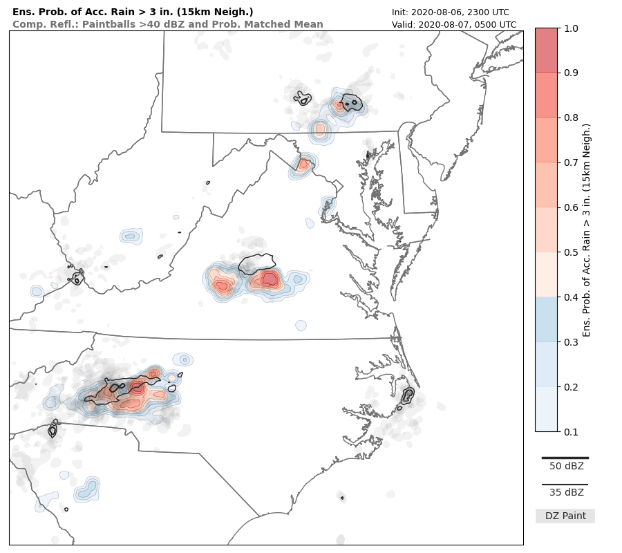
Another powerful WoFS product is the probability of a given event occurring in the vicinity around any given location. One of these ensemble probabilities is shown here, produced from the same 7:00pm EDT run of WoFS shown in the loop above. This forecast tells us there is a 70% chance of rainfall exceeding 3 inches in and around Leesburg, VA, over the 6-hour long period of the forecast. This is the type of information we hope can give forecasters added confidence when they are deciding when and where to issue a warning. The 7:00pm WoFS forecast was available more than one hour prior to issuance of the Flash Flood Emergency Warning for Leesburg.
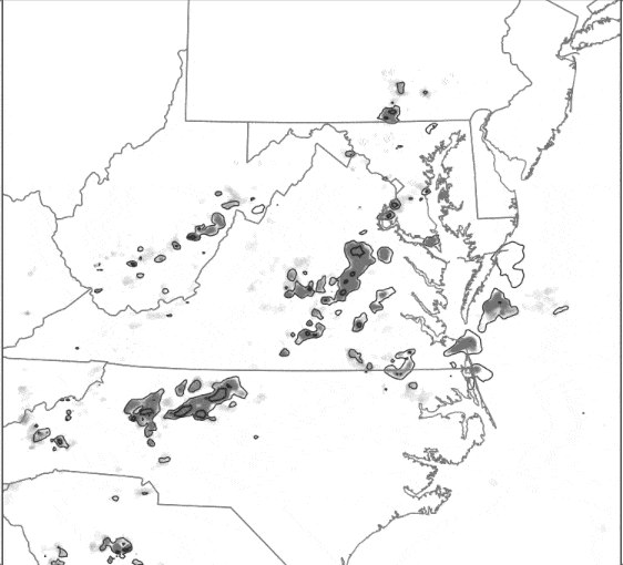
And while this particular forecast was on point for Leesburg, it is important to note that the model produced other moderate probabilities for thunderstorms in Maryland and Pennsylvania where the real-world storms ultimately did not persist long enough to produce 3 inches of rain. Forecasters must continue to use all tools and all clues during warning operations, but the probabilistic information that WoFS provides will give forecasters a more complete assessment of the range of possibilities than they have traditionally had at their disposal. The table below lists the real-time reports of flash flooding for this case in the preliminary National Weather Service record.
Preliminary reports of flash flooding in Leesburg from the National Weather Service:
| Time (EDT) | Location | Type | Description |
|---|---|---|---|
| 9:31pm) | 1 NW Leesburg) | Flash Flood | Dry Mill Rd. closed between Valley View Ave SW and Loudon St. SW due to Branch Creek out of its banks. |
| 10:00pm | 2 NNW Leesburg | Flash Flood | Several water rescues ongoing near and north of Leesburg. |
| 10:00pm | 3 S Waterford | Flash Flood | Route 7 eastbound closed at Charles Town Pike Route 9 due to high water. |
| 10:00pm | Leesburg | Flash Flood | Limestone Branch in Leesburg has risen 7.5 feet in the last hour and is in moderate flood stage and rising. At this level, water begins to enter homes near the stream and approaches US-15. |
| 10:10pm | Waterford | Flash Flood | South Fork Catoctin Creek at Waterford has risen 7 feet in the last 50 minutes and is approaching moderate flood stage. At this level, portions of VA-602 First Street are flooded, and water is approaching Main Street in downtown Waterford. |
| 10:34pm | 2 ENE Leesburg | Flash Flood | Edwards Ferry Rd at Battlefield Parkway closed due to high water. |
| 10:42pm | 3 NNE Leesburg | Flash Flood | Water rescue on US-15 James Monroe Highway near Raspberry Drive. |