

PARISE Archive
PARISE 2013
The Phased Array Radar and Meteorological Studies Team will be conducting three data collection efforts this spring:
- Detection and Adaptive Scheduling Experiment (DASE)
- Rapid-Scan Polarization Experiment (RSPE)
- 2013 PARISE
As the name implies, DASE will be taking advantage of the improved adaptive scanning capabilities of the MPARSUP 2013 spring release. The RSPE will be taking advantage of the return of KOUN for research use and will be used as a proxy for future dual-polarization PAR observations.
Scientific goals of DASE:
- Evaluate performance of the ADAPTS-3 upgrade.
- Demonstrate and evaluate of the use of new storm detection, tracking, and focused scheduled scanning capabilities.
- Understand the evolutionary processes within a thunderstorm as it evolves into a downburst, including the precursor signatures and their operational uses for enhanced warning lead time.
- Understand the evolutionary processes within a thunderstorm as it evolves into a supercell and subsequent tornadogenesis, and to evaluate low-altitude single-Doppler circulation and areal expansion rates in convergent vortex signatures.
Scientific goals of RSPE:
- Observe rapid temporal changes in dual-polarization signatures that occur in cyclic supercells.
- Observe rapid temporal changes in dual-polarization signatures that occur in downbursts.
2013 PARISE:
During six weeks in May, June, and July, NSSL will be working with 12 National Weather Service (NWS) forecasters to assess how the use of rapid-scan phased array radar data assists situational awarness and warning decisions during simulated severe weather events.
PARISE 2012: Use of PAR data for tornado warning decisions
Twelve NWS forecasters are participating in the 2012 PARISE, which runs for six weeks during June–August 2012. Two forecasters participate each week. The experiment's goal is to test whether rapid, adaptive sampling with the phased array radar at the National Weather Radar Testbed increases NWS forecasters’ ability to effectively cope with tough tornado warning cases.
During the experiment each forecaster works four cases ranging from 18–52 min in length. Their activity is videotaped. For each case, the forecasters’ goal is to decide whether a tornado warning is warranted.
Before each case, the forecasters receive a pre-recorded weather briefing that provides situational awareness of the environment. The forecasters then work the case in displaced real time using AWIPS II. RecordMyDesktop software records forecaster interaction with the radar data.
After each case, the forecasters review the video and works with researchers to build a timeline of their actions, what they saw and interpreted in the data, and their decision process. They also complete confidence and mental workload rankings.
Finally, forecasters draw pictures and describe the conceptual model they developed during each case.
Findings from the experiment will be presented at the upcoming Severe Local Storms Conference in November.
Phased Array Radar Spring 2012 Experiments
The NOAA National Weather Radar Testbed Multi-function Phased Array Radar supported three experiments with data collection during during the spring of 2012.
NSSL has partnered with MIT/Lincoln Labs and the FAA on the Multi-function Phased Array Radar’s (MPAR) Wind-Shear Detection Capability Assessment Experiment. Low-altitude wind shear is a deadly threat to aircraft during landing and takeoff and its accurate and timely detection near airports is critical. Microbursts, in particular, are fairly small and evolve rapidly. There are 45 Terminal Doppler Weather Radars (TDWR) currently serving U.S. airports. MPAR’s have the potential to replace TDWRs at the end of their life cycle, provided they can effectively detect wind shear. Researchers will compare radar data from the Oklahoma City TDWR with data from the NOAA MPAR.
The Deep Convective Clouds and Chemistry (DC3) experiment is exploring the role of the thunderstorm updrafts in carrying electrically charged particles, water vapor and other chemicals to the upper parts of our atmosphere. Scientists will use research aircraft, mobile radars, lightning mapping arrays and other tools to make measurements that will help scientists understand more about the electrical and chemical structure of thunderstorms, including the concentration of ozone. DC3 will focus on Alabama, Colorado and Oklahoma, but when thunderstorms are within 120 km of the Multi-function Phased Array Radar in central Oklahoma, teams will coordinate data collection. The project ran from May 15–June 30, 2012 with funding from the National Science Foundation (NSF), National Oceanic and Atmospheric Administration (NOAA), and NASA.
The Severe Weather Outbreak Study is a NOAA NSSL program to determine the importance of rapid and adaptive scanning from MPAR in the depiction and understanding of weather events with potential for significant societal impacts.
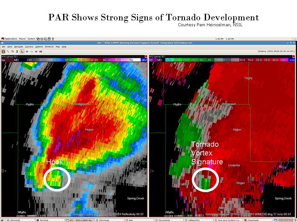
PAR Captures Long-lived Tornado in May 24, 2011 Outbreak
Posted on May 25, 2011
The tornado outbreak forecasted by the NOAA Storm Prediction Center and the National Weather Service Forecast Office in Norman, Oklahoma became a reality as five damage-producing tornadoes struck central Oklahoma between 3 pm and 7 pm CDT May 24, 2011. The longest-track tornado, rated EF3 by the Norman Forecast office, damaged homes and businesses along its 75-mile path that originated just northwest of Binger and moved through the towns of El Reno, Peidmont, and Guthrie (Fig. 1).
The rapid-scan, S-band phased-array radar (PAR), located within the National Weather Radar Testbed in Norman, Oklahoma, sampled this tornadic supercell every 1 minute. Based on PAR data, by 3:30 pm supercell storm formed its first well-defined hook echo and associated tornado vortex signature about 6 miles west of Binger (TVS; Fig. 2). At this time, PAR data show that the TVS had a maximum gate-to-gate velocity difference of 89 mph. A comparison of PAR velocity data with the damage path shows that the tornado formed about 12 minutes later, at 3:40 pm.
The 1-minute updates of the PAR exhibit many important details about the evolution of this supercell and its long-lived tornado. One example is the hard-right turn of the TVS and hook at 4:15 pm that placed El Reno in the tornado's destructive path (Fig. 3 .ppt 10 MB; ~62 km northeast of PAR). About 10 min later (4:25 pm, west-side of El Reno), as cells approaching from the southeast began to merge with the hook and a new circulation developed, the hook's motion was redirected to the northeast, toward Piedmont. Fig. 3 also shows the likely development of two “debris” signatures in the radar reflectivity, which are compact regions of high reflectivity values due to debris from the tornado.
This example shows the PAR's capability to provide timely, detailed information about where a tornadic storm is headed, and its intensity. In the future, this PAR capability may give families the few additional minutes they may need to take cover from destructive storms.
Findings from social science component of 2010 Phased Array Radar Innovative Sensing Experiment (PARISE)
PIs: Pam Heinselman (NSSL), Daphne LaDue (CAPS), and Heather Lazrus (SWWIM)
Radar data users weigh in
Researchers conducting the 2010 Phased Array Radar Innovative Sensing Experiment (PARISE) asked operational forecasters to use MPAR data as part of a simulated warning process in an operational environment. They wanted to study the possible impacts of quickly updating radar data on the warning decision making process and how MPAR data may be eventually introduced to the field. Preliminary analysis of one sample simulated case shows participants used rapid updating MPAR data to issue a tornado warning 21 minutes before the tornado touched down. This is a significant increase over the average 14-minute tornado warning lead-time. MPAR has strong potential to aid meteorologists in the forecast and warning decision process, helping to protect the public.
See paper published in Weather and Forecasting for details (download .pdf, 2 MB).
NSSL/CIMMS team wins prestigious award for phased-array radar research paper
NSSL’s Dr. Pamela Heinselman, along with NSSL/Cooperative Institute of Mesoscale Meteorological Studies, David Priegnitz, Kevin Manross, Travis Smith and Richard Adams are the winners of the twenty-second Professor Dr. Vilho Vaisala Award for an Outstanding Research Paper.
This same paper was selected as a 2009 Outstanding Scientific Paper Award from NOAA’s Office of Oceanic and Atmospheric Research.
The winning paper describes a study that demonstrated the National Weather Radar Testbed Phased Array Radar’s capability for adaptable, high temporal resolution scanning of quickly developing features in deep convective storms.
Heinselman, P. L., D. Priegnitz, K. Manross, T. Smith, and R. Adams, 2008: Rapid sampling of severe storms by the National Weather Radar Testbed Phased Array Radar. Wea. Forecasting, 23, 808–824. (download .pdf, 8MB)