
Research Tools: Observation
Science relies on observations to develop theories about nature, and ultimately to evaluate and validate these theories. These observations come from our natural senses and from instruments we create. The sustained development of advanced instrumentation continues to open new horizons in our understanding about how nature, including the multitude of processes in our atmosphere, really operates.They also provide the necessary starting point for creating models and simulations of the atmosphere used for understanding and predicting severe weather.
A significant part of our specialized instrumentation is built and maintained by the Collaborative Observations, Research, and Engineering (CORE) Branch, who work hard to come up with innovative ways to support NSSL's storm research efforts.
Field Observing Systems
Mobile Doppler RADAR
NSSL researchers teamed up with The University of Oklahoma to build the first mobile Doppler radar in 1993. Later versions of mobile radars (for example, NSSL's NOXP) were parked very close to storms, observing details below the beam of distant WSR-88D radars. NSSL has also used mobile radars to study tornadoes, hurricanes, dust storms, winter storms, mountain rainfall, and even swarms of bats. Today, NSSL welcomes a new fleet of mobile radars called RAPTORs (Rapid-deployable Agile Polarimetric Transportable Observational Radars) to deploy research-grade technology to the front lines of tornadoes, wildfires, hail storms, flash flooding and severe wind events, significantly expanding critical insight into hazardous weather threats in real time.
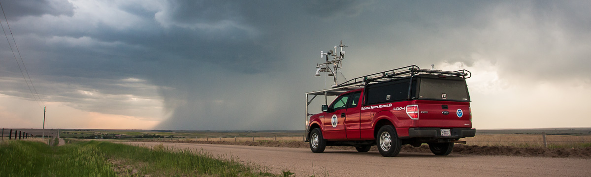
Mobile Doppler LiDAR
NSSL developed and maintains a Doppler Wind LiDAR system mounted in the bed of a pickup truck. This system is designed for rapid deployments near storms. It has been used to measure rapid fluctuations of winds near the ground near and inside tornadoes, providing a key instrument for meeting goals of NSSL projects, like PERiLS and LIFT. A mesonet rack takes measurements of the conditions in front of the vehicle and a hail cage allows for teams to operate close to the storm in any position. The system has a variety of other uses, such as validating wind measurements from colocated UAS and providing measurements of turbulence near the ground. It is also equipped with a Vaisala sounding system for taking radiosonde observations in the field.
Hail Camera
NSSL developed and maintains a camera system mounted in the bed of a pickup truck to take high-speed stereoscopic images of hail in freefall.
Collaborative Lower Atmospheric Mobile Profiling System (CLAMPS)
NSSL has a mobile, trailer-based boundary layer profiling facility using commercially available sensors. CLAMPS contains a Doppler lidar, a multi-channel microwave radiometer (MWRP), and an Atmospheric Emitted Radiance Interferometer (AERI). CLAMPS meets a NOAA/NWS operational and research need for profiles of temperature, humidity, and winds near the surface of the earth. CLAMPS also has the ability to support weather balloon launches and measure surface weather.
Mobile Mesonets and Mobile Soundings
The mobile mesonet is a vehicle intended to take surface observations of temperature, pressure, humidity, wind, and even solar radiation in and around storms and storm environments. Originally designed in 1992 by scientists and technicians from NSSL and The University of Oklahoma, these “probes” have undergone significant improvements over the years. Now, highly modified trucks are used to take these observations using a custom-designed roof rack and a complex of computer and communication equipment. Given that operating in severe weather comes with severe weather hazards, researchers added a hail cage to the vehicles to protect the windshields from damage.
In addition to surface observations, upper air observations are a critical component of meteorological observations. The National Weather Service launches weather balloons twice a day from locations across the country to measure vertical profiles of temperature, pressure, humidity, and winds. These observations form the backbone of numerical weather prediction and give us a picture of what the vertical component of the atmosphere looks like. Given this importance, the NSSL mobile mesonets now have the capability to launch soundings from any location at any time. The vehicles carry helium tanks in the back, and researchers can launch a balloon within a few minutes after arriving at a location. Mesonet vehicles are equipped with either a Vaisala radiosonde system used for full vertical profiles of the atmosphere or with Sparv Embedded Windsonds used for more rapid sampling of the atmosphere in and near storms.
2-Dimensional Video Distrometer (2DVD)
NSSL's 2DVD takes high speed video pictures, from two different angles, of anything falling from the sky through its viewing area, such as raindrops, hail or snow. It measures rain rate, drop shape and size distribution, which is used in polarimetric radar studies to refine precipitation identification algorithms.
Portable In situ Precipitation Station (PIPS)
The Portable In situ Precipitation Stations are small portable weather platforms built by NSSL in collaboration with The University of Oklahoma and Purdue University. Each PIPS has sensors that measure temperature, pressure, humidity, wind speed and direction. In addition, the PIPS determines the distribution of particle sizes by using an instrument called a Parsivel (PARticle, SIze, VELocity) disdrometer to measure the number and size of any object that falls through it (similar to the 2DVD). These can be deployed quickly in the field in any condition, and have even been used in hurricanes!
Particle Size Image and Velocity Probe (PASIV)
NSSL has built a one-of-a-kind, balloon-borne instrument called the Particle Size Image and Velocity probe, designed to capture high-definition images of water and ice particles as it is launched into, and rises up through, a thunderstorm. The instrument is flown as part of a “train” of other instruments connected one after another to a large balloon. These other instruments measure electrical field strength and direction, and other important atmospheric variables such as temperature, dew point, pressure and winds. Data from these systems helps researchers understand the relationships between the many macro and microphysical properties in thunderstorms.
Electric Field Meters (EFM)
NSSL's Field Observing Facilities and Support group (FOFS) is responsible for a device called an Electric Field Meter, EFM, that is attached, along with other instruments, to a special research balloon and launched into thunderstorms. As they are carried up through electrified storms, these EFMs are designed to measure the strength and direction of the electric fields that build up before lightning strikes occur. Data from this instrument helps researchers learn more about the electrical structure of storms.
Uncrewed Aircraft Systems (UAS)
NSSL uses Uncrewed Aircraft Systems (UAS) to better measure the atmospheric conditions and to better understand the impacts of tornadoes, thunderstorm winds, and flash flooding. The Coptersonde, developed by the University of Oklahoma, NSSL, and CIWRO, is a key component of NSSLs efforts to better observe the lower atmosphere. The very high resolution imagery collected by our fixed-wing and commercial off-the-shelf UASs can capture information with visible and multi-spectral imagery that is frequently missed with traditional damage survey approaches. Learn more
Learn more about UAS for weather sensing (wxUAS)
Learn more about UAS for mapping damage
Fixed Observing Systems
Oklahoma Lightning Mapping Array (OKLMA)
NSSL installed, operates and maintains the OKLMA. Thousands of points can be mapped for an individual lightning flash to reveal its location and the development of its structure. NSSL scientists hope to learn more about how storms produce intra-cloud and cloud-to-ground flashes and how each type is related to tornadoes and other severe weather.
Satellite
NSSL researchers are working on products that use GOES satellite data to identify rapidly growing clouds that might indicate a developing thunderstorm. They are also working on products that estimate wind shear and stability in the surrounding environment to forecast the future severity of the storm.
Boundary layer profilers
NSSL uses special instruments mounted on the top of the National Weather Center to measure the thermodynamic properties of the lowest one to two kilometers of the atmosphere, known as the boundary layer. Researchers study the data to learn more about the structure of the boundary layer, shallow convective cloud processes, the interaction between clouds, aerosols, radiation, precipitation and the thermodynamic environment, mixed phase clouds, and more. Numerical models, such as those used for climate and weather prediction, have large uncertainties in all of these areas. Researchers also use these observations to improve our understanding and representation of these processes.
Public Reports
mPING
NSSL uses observations from people too! In the Meteorological Phenomena Identification Near the Ground (mPING) project, volunteers can report on the precipitation that is reaching the ground at their location through mobile apps (iOS and Android). Researchers compare the reports of precipitation with what is detected by the dual-polarized radar data to refine precipitation identification algorithms.
Tornado Tales
Has a tornado hit your house or your community? Have you received a tornado alert? NOAA scientists want to hear your story.
The Tornado Tales citizen science tool is an online survey that provides a way for people to anonymously report their tornado experiences. Developed by researchers at the NOAA National Severe Storms Laboratory (NSSL), the tool will be used to better understand how people receive, interpret and respond to tornado information from NOAA.
The survey asks basic questions to collect information about an individual’s responses to warnings and watches, including how they prepared for and monitored the weather and what safe space they used to shelter when a warning was issued by NOAA’s National Weather Service. This information can help NOAA identify areas where warning messages may not be resulting in the most safe and effective actions. This knowledge will help NOAA hone safety messages.
Past Research Highlights
SHAVE
Another way NSSL has used public observations was through the mostly student-run NSSL/CIMMS (now CIWRO) Severe Hazards Analysis and Verification Experiment (SHAVE) project. SHAVE workers collected hail, wind damage and flash flooding reports through phone surveys. SHAVE reports, when combined with the voluntary reports collected by the NWS, created a unique and comprehensive database of severe and non-severe weather events and enhanced climatological information about severe storm threats in the U.S.
TOtable TOrnado Observatory (TOTO)
The TOtable TOrnado Observatory (TOTO), named after Dorothy's little dog from the movie “The Wizard of Oz,” was a 300 lb aluminum barrel outfitted with anemometers, pressure sensors, and humidity sensors, along with equipment to record the data. In theory, a team would roll TOTO out of the back of the pickup in the path of a tornado, switch on the instruments, and get out of the way. Several groups tried to deploy TOTO over the years, but never scored a direct hit. The closest TOTO ever came to success was in 1984 when it was sideswiped by the edge of a weak tornado and was knocked over. TOTO was retired in 1984.