
INTRODUCTION
Overview: The May 03 event seemed to
be a worst case scenario in terms of threatening lives and property.
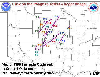
The National Weather Service(NWS) has, thus far, identified 8 supercell
thunderstorms which produced 59 discernable tornadoes in Central Oklahoma
alone. Many of these tornadoes were violent, longtrack, and struck
cities directly, including heavily populated Oklahoma CIty.
Public Warning: One of the silver linings to May 03, is the efficiency at which official tornado warnings were relayed to the public. The unique concentration of weather resources in Central Oklahoma undoubtedly saved lives. Storm spotters, including the NSSL VORTEX crew, and media severe weather coverage provided timely, accurate information to the NWS, and, in turn, the public. The long track nature of the more violent tornadoes also allowed for very early warning.
WDSS: WSR-88D data, however, is the primary tool for the NWS forecasters when dealing with severe weather. The Norman NWS Forecast Office is a test site for WDSS, a package of severe weather detection algorithms and special display software developed at NSSL. WDSS was in operation on May 03. This case study will focus on the performance of the NSSL Mesocyclone Detection Algorithm (MDA), the NSSL Tornado Detection Algorithm (TDA), and the NSSL Bounded Weak Echo (BWER) algorithm, as well as a WRS-88D overview of the storms.
Follow these links for background information on the NSSL
MDA and NSSL
TDA.
![]() Storm
A - The Oklahoma City Supercell
Storm
A - The Oklahoma City Supercell
![]() Storms
B,G - Anadarko to Mulhall, El Reno to Mulhall
Storms
B,G - Anadarko to Mulhall, El Reno to Mulhall
![]() Storm
D - Pink to Shawnee to Stroud
Storm
D - Pink to Shawnee to Stroud
![]() Storms
C,E,H,I - The Dover Storm and Others
Storms
C,E,H,I - The Dover Storm and Others
![]() Summary
of WDSS Algorithm Performance
Summary
of WDSS Algorithm Performance
![]()
![]()