2. INTERPRETATION OF DOPPLER VELOCITY PATTERNS IN CLEAR AIR AND WIDESPREAD PRECIPITATION
2.1 Introduction
In the absence of significant vertical motion, Doppler velocity patterns in widespread stratiform precipitation and in optically clear air represent the environmental wind field. Depending on season and time of day, coherent clear-air return can extend to ranges of 50–100 km (27–54 n mi) and to heights of 1–3 km (3–10 kft). For the simulations presented in this chapter, the wind is assumed to be uniform at each height but can vary from one height to the next; exceptions to this assumption are presented in Section 2.3. The assumption of horizontal uniformity is a realistic approximation to real data.
For a Doppler radar scanning 360° at a given elevation angle (Fig. 2.1.1), distance radially outward along the radar beam represents increasing height above the ground (really height above the center of the radar antenna). Thus, when the environmental wind field varies only with height, one 360° scan of the radar reveals winds at all heights from the ground up through the height of the edge of the radar scope display (for clear air, through the shallower depth of coherent radar return).
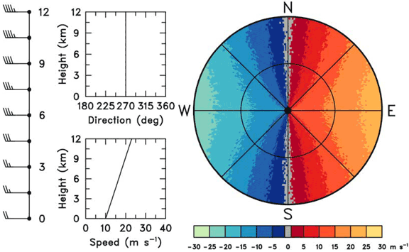
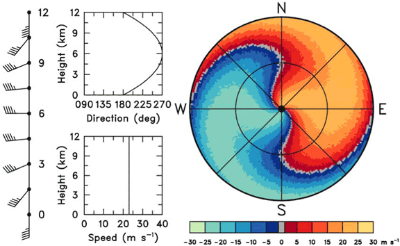
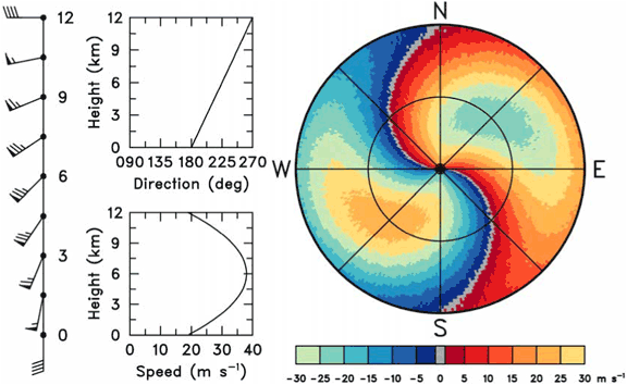
An example of an environmental wind field and corresponding color display of Doppler velocity values is shown in Figs. 2.1.2a and b. Since the choice of color scheme is based on personal preference, we chose contrasting colors that are obvious to those who cannot easily distinguish between reds and greens. The wind field is the same (26 m s-1 or 50 kt) at all heights. The wind direction changes uniformly from southerly at the ground (center of display) to westerly at the height of the edge of the display. Figure 2.1.2c indicates how to interpret wind direction along the gray zero Doppler velocity curve. The presence of the zero value indicates that the wind direction is perpendicular to the radial viewing direction from the radar at that location. For example, along the outer edge of the display, the Doppler velocity is zero when the radar points toward the north (point 1) and the south (point 7). This means that the wind is blowing either from west to east or from east to west at the height corresponding to the edge of the display. Since Doppler velocities are negative (component toward the radar) along the western edge of the display and positive (component away from the radar) along the eastern edge, the wind obviously is blowing from west to east at the height of the edge of the display.
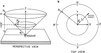
Fig. 2.1.1. Doppler radar viewing configuration. (a) Radar scanning around vertical axis, Z, at a constant elevation angle,φ ; (b) view of (a) from the top, representing a PPI (plan position indicator) display. Rs is slant range (on conical surface) of the edge of the display corresponding to height H above the ground. The three-dimensional position (x, y, h) of a radar scattering volume ("target") is computed from radar azimuth angle θ, elevation angle φ, and slant range rs. (larger image)
When the radar points toward point 2 on the zero band, it is pointing toward 330°. The wind direction at that point is 330° ± 90°. Since the wind is blowing generally from west to east, the wind at point 2 must be from 330° − 90° = 240°. Similar arguments at points 3, 5, and 6 result in wind direction of 300° − 90° = 210°, 120° + 90° = 210°, and 150° + 90° = 240°, respectively. At the radar location on the ground (point 4) the zero band is oriented east-west. Since the wind at the surface is approaching the radar from the south, the wind is blowing from 180°.
Wind speed at a given height (slant range) is determined by the extreme Doppler velocity values around a constant slant range circle (as displayed in Fig. 1.2.2). In Fig. 2.1.2b, the maximum flow away from the radar (light orange) and the maximum flow toward the radar (light blue) is the same from the center out to the edge of the display, indicating that the wind speed is constant (between 25 and 30 m s-1) from the ground to the height corresponding to the edge of the display. Thus the Doppler velocity pattern in Fig. 2.1.2b uniquely represents an environmental wind profile where wind speed is constant and wind direction veers uniformly from southerly at the ground through southwesterly to westerly at the edge of the display.
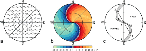
Fig. 2.1.2. Plan view of (a) environmental wind field and (b) corresponding single Doppler velocity pattern for wind with constant speed (26 m s-1 or 50 kt) and with direction changing uniformly from southerly at the ground (center of display) through southwesterly to westerly at the edge of the display. Part (c) illustrates how wind direction in a horizontally homogenous flow field can be interpreted using the zero Doppler velocity band. Uniform arrow length in (a) indicates constant wind speed with height. Colors in (b) indicate Doppler velocity values: positive values (red and orange) present flow away from the radar, negative values (blues) represent flow toward the radar. The lightest blue color category represents velocities < −25 m s-1 and the lightest orange category represents velocities > +25 m s-1. (larger image)
2.2 Patterns Associated with Vertical Profiles having Constant Wind Direction
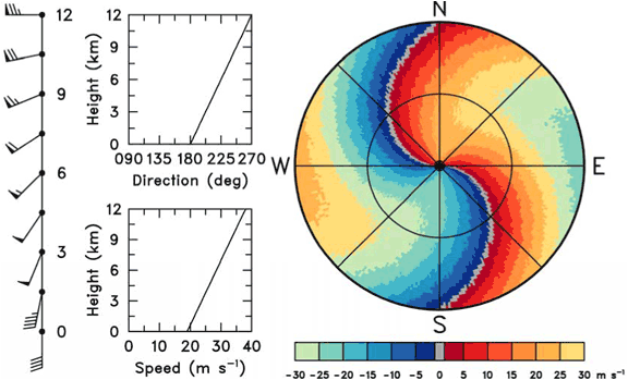
Doppler velocity patterns associated with the same wind direction at all heights always have a straight zero band. The rest of the pattern reflects the vertical profile of wind speed (Figs. 2.2.1–2.2.4).
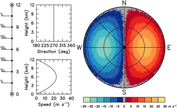
When wind speed is constant (non-zero) with height (Fig. 2.2.1), the extreme Doppler velocity values extend from the radar location at the center (ground level) outward to the edge of the display. Consequently, the colors representing all other Doppler velocity values must converge to a point at the display center.
When wind speed at the ground is less than the maximum value (but still greater than zero), those colors corresponding to wind speeds less than or equal to the surface value converge to the center of the display (Figs. 2.2.2 and 2.2.3). Those colors corresponding to greater speeds converge toward the center but never reach it. When wind speed at the ground is zero, only the zero band passes through the center (Fig. 2.2.4).
When a wind speed maximum exists within the height interval represented by the display, a pair of quasi-elliptical bull's eyes appear on the display (Figs. 2.2.3 and 2.2.4). The centers of the bull's eyes are positioned upwind (negative) and downwind (positive) of the radar at the slant range equal to the height of the wind maximum.
Note: The plotted wind barbs presented in this guide follow the customary convention: a short bard represents 5 kt (2.6 m s-1), a long barb represents 10 kt (5.1 m s-1), and a flag represents 50 kt (26 m s-1). The barbs and flags point toward lower pressure.
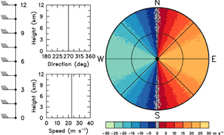
Fig. 2.2.1. Doppler velocity pattern (right) corresponding to a vertical wind profile (left) where both speed (23 m s-1 or 45 kt) and direction (270°) are constant with height. Negative (positive) Doppler velocities represent flow toward (away from) radar. Radar is at the center of the display.(larger image)
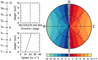
Fig. 2.2.2. Same as Fig. 2.2.1, except that the wind speed increases from 10 m s-1 (19 kt) at the ground to 23 m s-1 (45 kt) at the edge of the display. (larger image)
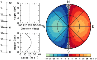
Fig. 2.2.3. Same as Fig. 2.2.1, except that the wind speed is a maximum of 23 m s-1 (45 kt) midway between the ground and the height corresponding to the edge of the display. Speed is 10 m s-1 (19 kt) at the surface and at the edge of the display. (larger image)
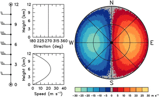
Fig. 2.2.4. Same as Fig. 2.2.3, except that wind speed is zero at the ground and at the edge of the display. (larger image)
2.3 Patterns Associated with Nonuniform Horizontal Wind Fields
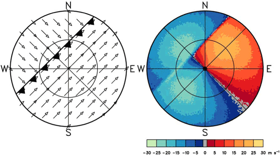
Everywhere else in this chapter, it is assumed that the environmental wind field is horizontally uniform. However, in this section, we explore some nonuniform features as discussed by Baynton et al. (1977). In Figs. 2.3.1 and 2.3.2, the horizontal winds at all heights are horizontally difluent and confluent, respectively. The straight velocity boundaries of Fig. 2.2.1 become curved, with the curve of the zero Doppler velocity line reflecting the change in wind direction across the display.
When the height of the wind speed maximum profile in Fig. 2.2.4 increases toward the east, variations in the wind profiles are like those shown in the left part of Fig. 2.3.3. The profile labeled W represents the wind in the western half of the display and the profile labeled E represents the wind in the eastern half of the display. The Doppler velocity display consists of an unsymmetrical bull's eye pattern representing the upward tilt of the maximum wind speed structure from west to east.
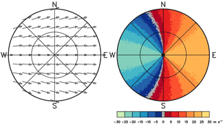
Fig. 2.3.1. Doppler velocity pattern (right) corresponding to a horizontal flow field that is difluent with the same speed (23 m s-1 or 45 kt) at all heights (left). Negative (positive) Doppler velocities represent flow toward (away from) the radar. Radar location is at the center of the display. (larger image)
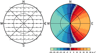
Fig. 2.3.2. Same as Fig. 2.3.1, except that the horizontal flow field is confluent with the same speed (23 m s-1 or 45 kt) at all heights. (larger image)

Fig. 2.3.3. Doppler velocity pattern (right) corresponding to a wind speed pattern (left) similar to that in Fig. 2.2.4 that tilts upward from west (W) to east (E). >(larger image)
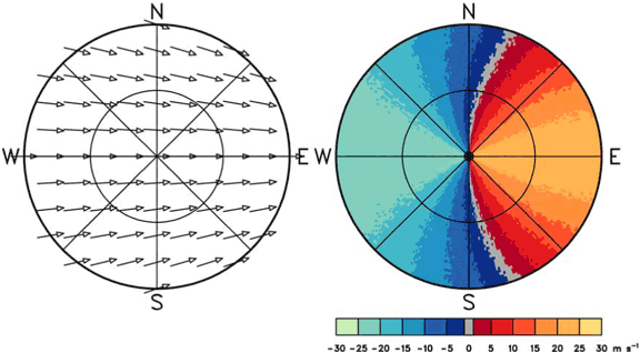
2.4 Patterns Associated with Vertical Profiles having Constant Wind Speed
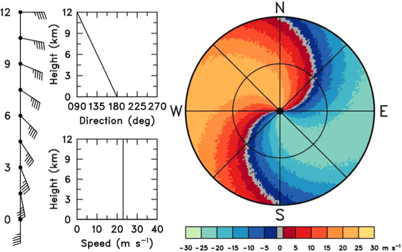
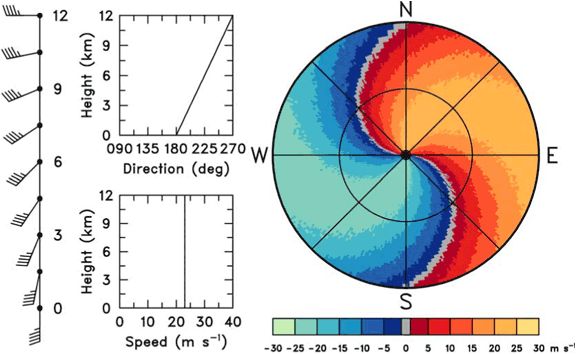
When wind speed is constant with height, all of the color velocity bands converge to the radar location at the center of the display. Curvature of the zero Doppler velocity line indicates the change of wind direction with height (see Fig. 2.1.2). Backing winds produce a backward S-shaped profile (Fig. 2.4.1) and veering winds produce an S-shaped profile (Fig. 2.4.2). When the wind direction veers then backs with height, an S-shaped profile changes into a backward S-shaped profile with increased range from (height above) the radar (Fig. 2.4.3).

Fig. 2.4.1. Doppler velocity pattern (right) corresponding to a vertical wind profile (left) with constant wind speed (23 m s-1 or 45 kt) and wind direction backing from southerly to easterly with height. Negative (positive) Doppler velocities represent flow toward (away from) the radar. Radar location is at the center of the display. (larger image)

Fig. 2.4.2. Same as Fig. 2.4.1, except that the wind veers with height. (larger image)
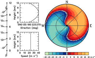
Fig. 2.4.3. Same as Fig. 2.4.1, except that the wind direction veers then backs with height. (larger image)
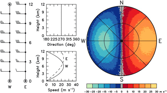
2.5 Patterns Associated with Vertical Profiles of Varying Wind Speed and Direction
A wide variety of Doppler velocity patterns are possible when both wind speed and direction vary with height. Figure 2.5.1 shows a variation of Fig. 2.4.2, where wind direction veers with height but where the speed increases with height instead of being constant. Since wind speed is zero at the ground in Fig. 2.5.1, only the zero velocity line passes through the radar location at the center of the display.
If the Doppler velocity dealiasing algorithm is not applied or is not functioning properly, Doppler velocity values that exceed the Nyquist velocity cointerval will produce an abrupt change in color from one end of the velocity cointerval to the other. This abrupt color change makes the presence of velocity aliasing very evident to the eye. In the example shown in Fig. 2.5.1, the Doppler velocities at the edges of the display are aliased because the wind speeds at those heights exceed an assumed Nyquist velocity cointerval of ± 30 m s-1 (58 kt).
When wind speed at the ground is greater than zero, color bands for velocities less than or equal to the surface wind speed converge to the center of the display (Fig. 2.5.2). The presence of a wind speed maximum aloft produces bull's eyes that are distorted due to the change of wind direction with height (Fig. 2.5.3). Note that all three of the Doppler velocity displays have aliased Doppler velocity values.
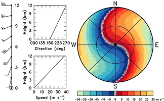
Fig. 2.5.1. Doppler velocity pattern (right) corresponding to a vertical wind profile (left) where wind speed increases from 0 to 38 m s-1 (74 kt) and direction veers from southerly to westerly with height. Negative (positive) Doppler velocities represent flow toward (away from) the radar. Note that Doppler velocities exceeding ±30 m s-1 are aliased. (larger image)
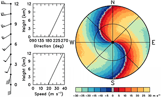
Fig. 2.5.2. Same as Fig. 2.5.1, except that the wind speed increases from 19 m s-1 (37 kt) at the ground to 38 m s-1 (74 kt) at the edge of the display. (larger image)
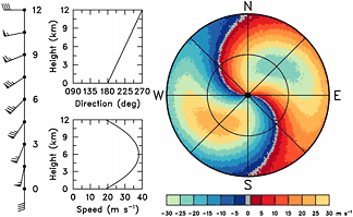
Fig. 2.5.3. Same as Fig. 2.5.2, except that the wind speed maximum of 38 m s-1 (74 kt) occurs at a height corresponding to the midrange of the display and decreases to 19 m s-1 (37 kt) at the edge. (larger image)
2.6 Patterns Associated with Vertical Discontinuities in the Wind Field
Figures 2.6.1 and 2.6.2 illustrate examples of Doppler velocity fields that pass through a horizontal surface that separates two different atmospheric flow regimes. It is assumed that there is a wind speed maximum within each wind regime and that the wind directions differ by 90° or 180°, respectively, across the discontinuity.
The discontinuity could represent a frontal surface or it could represent the top of the boundary layer in clear air. Note the variation of the zero Doppler velocity line in Fig. 2.6.1. It is oriented northeast-southwest through the center of the display indicating a constant wind direction in the lower layer. The inner pair of bull's eyes indicates that the wind is blowing from the southeast to northwest at a maximum speed of 25–30 m s-1 (49–58 kt). The zero velocity line indicates a 90° shift in wind direction through a narrow height interval, with the wind direction becoming constant again above the discontinuity. The second pair of bull's eyes indicates that the upper layer winds are from the southwest at a maximum speed of 25–30 m s-1 (49–58 kt).
The wind shift through the discontinuity is much more dramatic in Fig. 2.6.2 than in Fig. 2.6.1. The orientation of the zero Doppler velocity line and the locations of the positive and negative Doppler velocity extremes indicate easterly winds in the lower layer capped by westerly winds aloft.
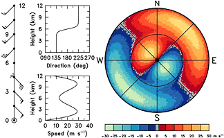
Fig. 2.6.1. Doppler velocity pattern (right) corresponding to a vertical wind profile (left) through a discontinuity between two wind regimes that differ by 90° in direction. Negative (positive) Doppler velocities represent flow toward (away from) the radar. Radar location is at the center of the display. (larger image)
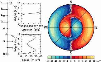
Fig. 2.6.2. Doppler velocity pattern (right) corresponding to a vertical wind profile (left) through a discontinuity between two wind regimes that differ by 180° in direction. (larger image)
2.7 Patterns Associated with Horizontal Discontinuities in the Wind Field
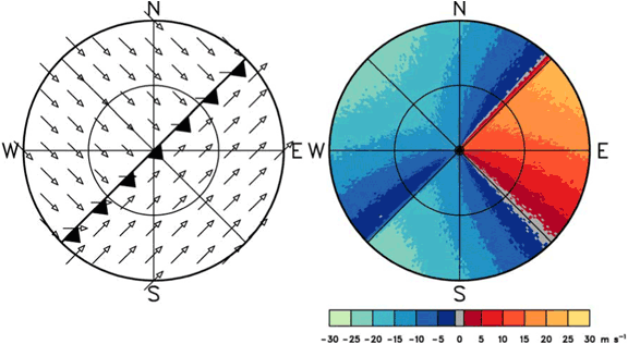
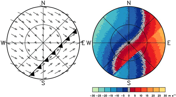
With adequate radar return, it is possible to determine characteristics of the flow field both ahead of and behind a horizontal discontinuity (such as a front, outflow boundary, wind shift line). Figures 2.7.1–2.7.3 clearly indicate that the discontinuity is marked by a rapid change of Doppler velocity values over a narrower transition region. The sequence of three figures shows the movement of the discontinuity approaching from the northwest, located over the radar, and finally moving away from the radar toward the southeast. Winds ahead of the discontinuity essentially are from the southwest and those behind the discontinuity essentially are from the northwest.
Different wind profiles are used in each figure. The variation in wind vectors is due to the change of wind with height. In Fig. 2.7.1, wind direction is constant on both sides of the discontinuity and wind speed is a maximum in the middle of the height interval (as in Fig. 2.2.3). Wind direction is constant on both sides of the discontinuity in Fig. 2.7.2, but wind speed increases linearly from the ground to the edge of the display (as in Fig. 2.2.2). In Fig. 2.7.3, wind speed increases with height from zero at the ground while wind direction veers ahead of the discontinuity (similar to Fig. 2.5.1) and backs behind it.

Fig. 2.7.1. Doppler velocity pattern (right) corresponding to the approach of a wind field discontinuity from the northwest (left). There is a southwesterly low-altitude velocity maximum of 22 m s-1 (43 kt) ahead of the discontinuity and a northwesterly velocity maximum of 22 m s-1 (43 kt) behind it. Wind speed at the ground is 11 m s-1 (21 kt). Arrow length is proportional to wind speed. Negative (positive) Doppler velocities represent flow toward (away from) the radar. Radar location is at the center of the display. (larger image)
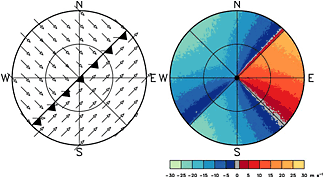
Fig. 2.7.2. Same as Fig. 2.7.1, except that the discontinuity is now over the radar. In both regions, wind direction is constant and wind speed increases from 11 m s-1 (21 kt) at the ground to 22 m s-1 (43 kt) at the edge of the display. (larger image)
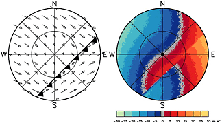
Fig. 2.7.3. Same as Fig. 2.7.1, except that the discontinuity is now southeast of the radar. Winds ahead of the discontinuity veer with height, while those behind the discontinuity back with height. In both regions, wind speed increases from 0 m s-1 at the ground to 22 m s-1 (43 kt) at the edge of the display. (larger image)
NSSL HOME >> DOPPLER GUIDE HOME >> CONTENTS >> CHAPTER 2 >> CHAPTER 3