


VORTEX2 Vehicles & Instruments
NOTE: Information about specific vehicle and instrument teams may be found here. Information about the scientific objectives of the various instruments may be found here.
 VORTEX2 will take full advantage of cutting-edge remote systems (collecting weather data from a distance), fixed observing systems (collecting data from a permanent location), and in-situ systems (collecting data by being in direct contact with the weather).
The VORTEX2 Operations Center (VOC) will be located at the National Severe Storms Laboratory in the National Weather Center to provide forecast support, logistical coordination, and a safety net for the field crew.
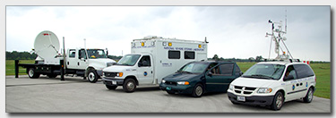
Field command vehicle — NSSL's field command unit (FC) will be used to organize and communicate storm intercept activities in real-time. Weather observations from other mobile instruments, mobile radar data, and location information are broadcast over a mobile digital radio network to the field coordinator. The FC then plots the information and directs team members to ideal field positions. Coordination during field projects is important to collect the most valuable data while keeping participants safe.

MWR-05XP photo courtesy Jeff Snyder
Mobile radars (10 total):
C band radars are used for short range weather observations and operate on a wavelength of 4–8 cm:
| Radar Name | Home Organization | Description |
|---|---|---|
| SMART-R (Shared Mobile Atmospheric Research and Teaching Radars) | Built in collaboration with NSSL, Texas A&M, Texas Tech and the University of Oklahoma | |
| SMART-R1 | C band (5 cm) | |
| SMART-R2 | C band (5 cm), recently upgraded to dual-polarization technology |
X-band radars operate on a wavelength of 2.5–4 cm. They are more sensitive and can detect smaller particles including cloud droplets. These radars can also be used to distinguish tornado debris clouds from precipitation:
| Radar Name | Home Organization | Description |
|---|---|---|
| DOW (Doppler on Wheels) DOW 6 and DOW7 |
CSWR | 3 cm |
| Rapid-DOW | CSWR | Transmits 12 simultaneous beams to collect samples every 5–10 seconds |
| NO-XP (NOAA/NSSL-OU X-Pol) |
NSSL | Dual pol |
| UMASS X-Pol | University of Massachusetts | 3 cm dual pol |
Ka-band radars operate on a wavelength of .75–1.2cm and are even more sensitive:
| Radar Name | Home Organization | Description |
|---|---|---|
| TTU-Ka-band | Texas Tech University (TTU) | 0.75–1.2 cm |
W-band radars achieve high sensitivity with small antennas and operate on a 3mm wavelength:
| Radar Name | Home Organization | Description |
|---|---|---|
| UMASS-W | University of Massachusetts (UMASS) | 3 mm, maps the reflectivity and Doppler velocity field at very high resolutions |
Mobile phased array radar:
| Radar Name | Home Organization | Description |
|---|---|---|
| MWR-05XP (Mobile Weather Radar-2005 X-band Phased Array) |
CIRPAS (Center for Interdisciplinary Remotely-Piloted Aircraft Studies), Naval Postgraduate School | Will be operated by OU to study tornadoes |
Deployable instrumentation
| Instrument Name | Home Organization | Description |
|---|---|---|
| Tornado PODs (12) | CSWR | 1 m tower of instruments with a flat base to measure wind velocity and direction at ground level, ideally in the core flow of the tornado |
| Sticknets (24) | TTU | 2 m tall tripods to collect complete wind datasets and atmospheric variables - 14 will measure the atmosphere - 10 will have the ability to record hail (acoustic) and precipitation |
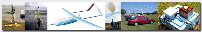
| Unmanned instrumented aerial system | CU, Rasmussen Systems, OU, University of Nebraska at Lincoln | Will be flown across outflow boundaries and beneath the supercell rear flank downdraft to measure pressure, temperature, relative humidity and wind velocities. |
| MGAUS (Mobile GPS Advanced Upper Air Sounding System) | NSSL (2) 130 sondes NCAR (2) 137 sondes |
Mobile ballooning facilities will launch balloons with instruments, or sondes, attached in key parts of the supercell. The sondes will measure temperature, pressure, relative humidity and winds. The data will be transmitted back to the mobile unit even if it is on the road. Will be used to sample the pre-storm environment, refine the V2 forecast target and more. |
| Mobile Mesonets | PSU, using NSSL mobile mesonets | Racks of surface weather instruments mounted on the roofs of vehicles to take measurements near storms. The instruments measure temperature, humidity, pressure, wind speed and direction, vehicle orientation and precise vehicle location by means of GPS. A special communication system allows the vehicles to automatically report data to a central command vehicle in real time. - 6 dedicated to surface measurements - 3 deploying tornado PODS |
| Particle probe (disdrometers and particle imagers) | CU, NSSL, OU | Used to measure the particle size distribution and velocity of falling hydrometeors. - 2 vehicle-mounted particle imagers at approximately 2m above the ground - 2 manned and 2 unmanned deployable disdrometer platforms |
| High Resolution DSLR cameras and GPS data loggers (Photogrammetry) | Lyndon State and NCAR | Collect high-resolution imagery of wall clouds, tornadoes and debris. Photos will be combined and compared with radar data. |
Fixed instrumentation
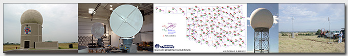
- NWRT (National Weather Radar Testbed)
The NOAA phased array radar located in Norman, Oklahoma includes - CASA (Collaborative Adaptive Sensing of the Atmosphere) Oklahoma Testbed

- Oklahoma mesonet
- OK-LMA
The OK-LMA detects and measures all types of lightning including flashes inside clouds. The 11-station OK-LMA provides high-resolution 3-D mapping of all types of lightning over west central Oklahoma and 2-D mapping over most of Oklahoma.

