
VORTEX2 Risk Analysis and Mitigation Project (V2RAMP)
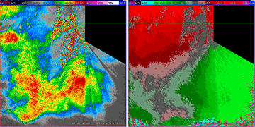
Reflectivity and (aliased) radial velocity in a developing tornadic supercell storm
Preliminary Summary
The VORTEX2 Risk Analysis and Mitigation Project (V2RAMP) operated on approximately 10 days between 15 May and 15 June 2008. The V2RAMP was implemented to test the communication and data sharing technologies needed for the VORTEX2 field program which is currently scheduled for spring 2009 and 2010 in the Great Plains. The principal implemented goals included the following:
- Test communication of tactical and meteorological information to a central command vehicle (FC) from a mobile Doppler radar (SR-1) and several mobile mesonet vehicles (MMs) through the use of a mobile digital network (MDN),
- Test providing real-time mobile radar volumes via a ultra-high bandwidth geostationary satellite dish system from SR-1 back to the Hazardous Weather Testbed (HWT) at the National Weather Center in Norman OK for experimental warnings,
- Determine the viability of various communication platforms (satellite, VHF radio, cell tower) and the use of new communication methods (text, voice, and video-over-IP),
- Test the new scanning/processing radar data collection from the upgraded signal processor in SR-1.
Although most operational days involved storm intercept, communications tests in clear-sky conditions and either including or excluding SR-1 were also conducted on 3 days. On some days with storms, only SR-1 was deployed to conduct radar sampling mode tests.
The overall, preliminary results by objective during V2RAMP are described as follows:
- Vehicle-to-vehicle MDN communications:
The four (4) vehicles—field coordination (FC), the two (2) mobile mesonets (MM), and the SR-1—were each equipped with a FreeWave 900 MHz radio-frequency, Internet-Protocol modem to transmit digital data between the vehicles. The rooftop box and software of each MM were specially modified to handle the new IP radio modems. Average bandwidth per packet was archived by each MM transmitting its observations to FC. The MM-to-FC connection was fully successful, including bandwidth ranging from ~200 Kbit/s within ~1 km (when vehicles were traveling and FC mast was stowed) down to ~75 Kbit/s near the radio horizon (when MMs were conducting legs and FC was parked with its 10-m mast extended) and ranges up to ~25 km or greater. In instances where line-of-sight was broken, data packets were archived and automatically streamed to FC when line-of-sight was reestablished. Text messaging between platforms using the IP radios was very successful, providing a written record to supplement (and in some cases replace) VHF radio communications which were also available. Received MDN packets were plotted using the Unidata IDV software, with overlays of MM station models, roads, rivers, tall towers, and geographic borders on either DORADE-format SR-1 radar sweep files, visual GOES images, or NEXRAD-composite radar reflectivity images. - Real-time SR-1 radar volumes via satellite to HWT:
The SR-1 was equipped with the MotoSat XF3 self-pointing, 1.2 m dish satellite communications system. An Ethersat Internet service plan with a 25:1 customer-to-transponder ratio and a nominal 768 Kbit/s upload channel bandwidth was selected. The capability was enabled to automatically transmit raw radar volume data from the SIGMET computer to the HWT in the following steps:- SIGMET format data volume via NFS mount to SR-1 data server,
- SR-1 data server via XF3 satellite transmission to University of Oklahoma (OU) web server,
- OU server to WDSS-II server inside NOAA/NWC firewall via LDM,
- SIGMET radar volume pre-processed by WDSS-II server,
- Near-real-time display of SIGMET radar volume in WDSS-II workstation in HWT staffed by V2RAMP Nowcaster.
- Viability of new communications platforms (satellite, VHF radio, HF radio, cell tower) and methods (text, voice, and video-over-IP):
Satellite communications, as described above, proved to be viable for real-time radar data communications provided the vehicle was parked and high winds did not cause the antenna to be unstable. An upgraded MotoSat F1 satellite dish system was used on the FC vehicle to browsing weather data images on the Internet. The F1 system was very slow (~10-15 min to acquire satellite, ~5 min to stow) and frequently failed to acquire satellite, suggesting the need for upgrade to a faster and more reliable satellite dish system for V2. The Baron Service Threat-Net weather image data system, which only receives scheduled downloaded image data, was tested in the FC and determined to be very robust and potentially useful for FC and radar operations during V2. VHF radio was useful and practical provided platforms were within radio line-of-sight. HF radio proved to be impractical for application to mobile field operations. The "Internet-in-Motion" (I-I-M) cell phone router technology, which included automatic connectivity to Sprint and Alltel service, proved to be very useful in the field in spite of highly variable bandwidth and substantially lower and patchy connectivity in many rural areas compared to Interstate, US, and major state highways. The I-I-M technology was used in the FC, SR1, and radar Scout vehicles, both for browsing weather images and for maintaining text chat sessions between the platforms and the Nowcaster at the HWT. Cell phones were also used for communications, although similarly to the I-I-M connectivity was rather limited in rural areas. The "video-over-IP" connections proved to be impractical due to a requirement for high, sustained bandwidth which could not be achieved by the I-I-M devices. - New radar data scanning and processing techniques using the upgraded SIGMET RCP-8/RVP-8 radar controller and signal processor in SR-1:
Approximately ten (10) storm deployments involving 15 experiments were performed using SR-1. Three of the 15 experiments involved data "pushing" as the primary objective. Of the remaining 12 radar experiments, at least five of those tests have obtained good results from the utilized signal processing methods. Varying comparisons of the following scan modes were tested:- dual 3/2 ratio PRF,
- high PRF,
- random phase,
- dual-random phase,
- staggered 3/2 ratio PRF, and
- staggered 5/4 ratio PRF.