Diagnosis
of precipitation efficiency from GOES, WSR-88D and RUC analyses
1NOAA/NSSL and
UW-Madison/CIMSS
A significant winter storm effected much of the
central and eastern
U.S. during the 12-14 February 2007. A surface low pressure
system moved from the southern plains to the Ohio valley producing
heavy snow and near blizzard conditions through portions of the Midwest
and Great Lakes. By the morning of the 14th, a coastal low
developed off the mid-Atlantic coast and moved northeast just offshore
of the
east coast. Areas along the coast received precipitation mostly in the
form of ice pellets and freezing rain. Further inland (portions
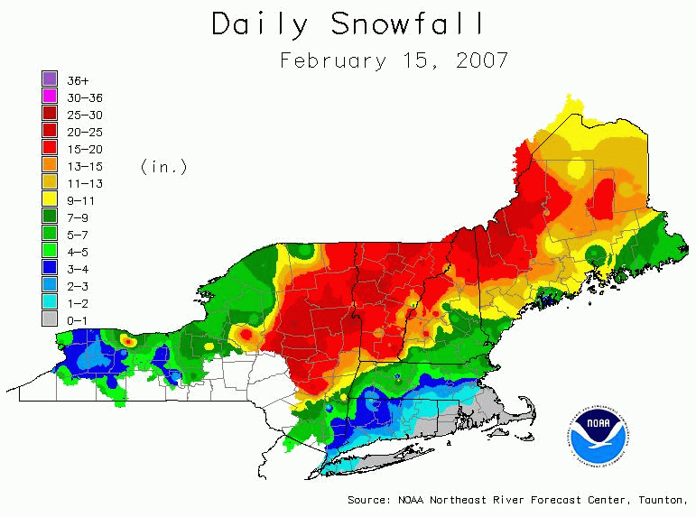
of interior Pennsylvania, New York, and New England) received from 1-2
ft of snow (Fig. 1). In
portions of Vermont (e.g. Burlington), this was
the 2nd largest snow storm and greatest 24 hr snowfall on record.
Estimates of 24 hr liquid equivalent precipitation from radar only and
radar plus gauge are given in Fig. 2.
This web page compares attributes of precipitation
efficiency from GOES cloud top information, reflectivity profiles from
WSR-88D radars, vertical air motion from RUC analyses, and divergence
aloft from GOES water vapor winds.
Ascending, saturated air near the -15 C
temperature layer is an important condition for dendritic ice
growth and formation of heavy snow. The estimated pressure level
of -15 C, P(-15 C),
from GOES cloud top temperature and pressure are compared to measured
levels from rawinsondes (Table 3) for this case study. As seen in
Table 4, the estimated levels from GOES are typically 10-50 mb too low
(higher altitude). These differences can be attributed to
deviations from the moist adiabatic lapse rate (within the layer from
cloud top to -15 C). Although the upper portions of the sounding
were often very close to moist adiabatic in regions of deep rising
motion, the lapse rate was usually less steep a few hundred millibars
above the strong inversion
associated with the dome of polar/arctic air near the surface.
This error in P(-15 C) estimated from
GOES is not expected to be significant for storms with intense
vertical motion through a deep layer. Note that estimated and
observed
pressure
levels of -15 C are in the mid levels of the troposphere, close to the
level of non-divergence,
and are similar to heavy snow storms examined by Auer and White (1982).
An indication of significant air ascent at -15 C
can be obtained from the estimated omega variable (dP/dt) from the RUC
analysis at the pressure level nearest to P(-15 C) at any grid
point. Movies of omega at 850, 700, 500, and 300 mb can be viewed
in Table 1 (W(850) -
W(300)). Note that negative values of omega correspond to upward
air motion. Applying a threshold of omega at each point of the
RUC grid, the values of P(-15 C) are shown only where omega is less
than -5
microbar/s (background images: Table 1, column 2). Hence,
these
images show only areas where significant rising motion is expected at
the -15 C level. In addition, the value of the -15 C pressure level is
color
coded. Note that significant rising motion at -15 C (roughly near
500 mb) covers a large area receiving snow and frozen
precipitation from 12-23 UTC. This area is to the north and west
of the coastal storm as it moved northeast (surface reports can be
overlayed by clicking
"WX" on the figures in column 2, Table 1). At times,
there are reports of moderate snow rates outside of these areas.
This may be due uncertainties in the RUC omega fields, and/or that the
threshold of omega is too constrained.
The upper-level divergence from the GOES water vapor
winds can be used as a supplement or alternative to the model omega
fields (Table 1, last column). Divergence near 300 mb is derived
from motion vectors of water vapor and cloud features, and from a
global model wind field (NOGAPS) used as a first guess in deriving the
winds. A strong divergent pattern is centered
over the areas which received heaviest snow (central New York to
Vermont between 12-23 UTC). While it is not possible to
obtain vertical profiles of omega from the satellite winds, they do
give an indication of where deep layered ascent may be occurring, with
maximum ascent in the mid-levels (near the level of
non-divergence). Observations of strong divergence near 300 mb,
combined with P(-15 C) near the mid-troposphere, suggest substantial
ascent in the dendritic growth region.
Another important factor in the production of
snow is availability of moisture. The figures in Table 1, column
2 contain total Precipitable Water (PW) as on overlay. Note the
very large values of PW in close proximity to the coastal storm (32 mm
off the NJ coast), and moderate values in central New York state and
Vermont (12 mm).
The precipitation type in winter storms is not
only dependent on surface temperature, but also on the depth of
freezing and subfreezing layers, and on the relative humidity through
which
precipitation falls before reaching the surface. For example, the
height of the 0 C wet bulb temperature is often used to determine rain
versus snow at the surface. Assessing the probability of rain,
freezing rain, ice pellets, snow grains, or regular snow flakes, or a
mixture of these elements is very challanging owing to complex
microphysics and uncertainties in the detailed vertical temperature
profile at any particular place and time.
Monitoring the vertical temperature profile in the
lower portions of the cloudy atmosphere requires additional information
which cannot be provided by the GOES cloud top measurements. Other than
in-situ samples from rawinsondes, radar can provide some information on
the freezing level. Table 2 links to movies of vertical
reflectivity profiles from several WSR-88D radars in the area effected
by the storm. These profiles are derived from averages within
20-80 km of the radar at available elevation scans. Temperatures
obtained from the RUC analysis are shown as horizontal lines on these
figures. The plots (Vertical Profile of Reflectivity, VPR) were
obtained from the NOAA/NSSL National Mosiac and Quantitative
precipitation initiative (NMQ) web
site. A distinct maximum in the reflectivity profile exists
in the Upton, NY and Mt. Holly profiles near 2 km
AGL. Such peaks in reflectivity are commonly observed where ice
crystals fall into a layer of air with temperatures above 0 C and
become wet. The
peak in reflectivity is quite close to the top of the elevated 0 C
isotherm in the Upton, NY rawinsonde and in the RUC analysis.
Surface observations from near these sites experienced ice pellets
rather than snow.
The Albany, NY reflectivity profiles show a peak
near 1.5 km AGL which is most prominant between 16-18 UTC but is no
longer visible by 20 UTC. The 18 UTC rawinsonde at Albany shows a
peak temperature near freezing (-0.1C at 1.75 km AGL) but no
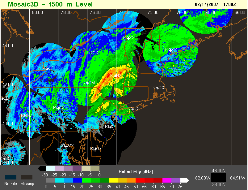
significant layer of above 0 C air is observed. The 3-D
reflectivity analysis at 17 UTC (Fig.
3) from NMQ reveals a band of enhanced reflectivity near 1.5 km AGL
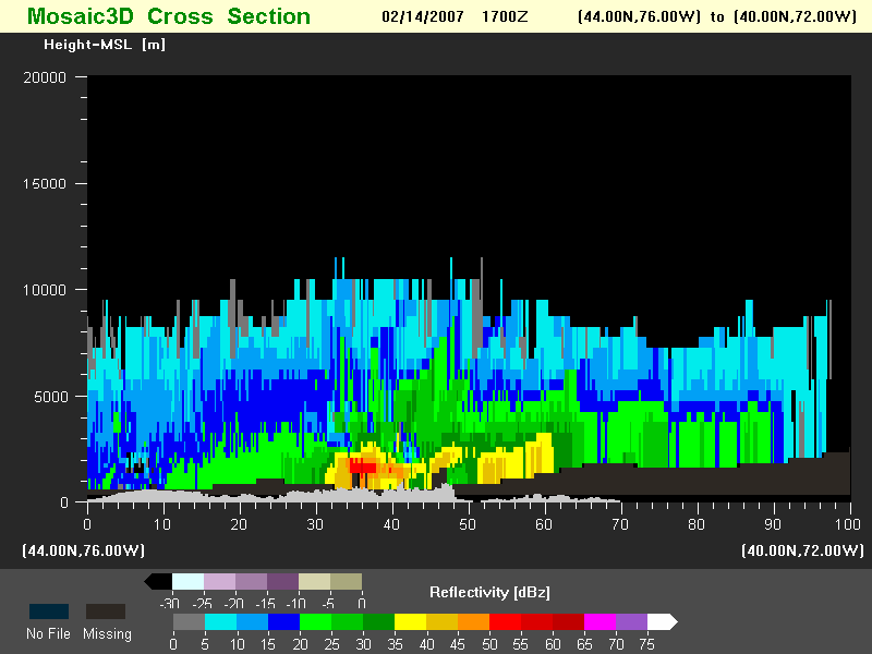
at Albany. A vertical cross-section centered on Albany (Fig. 4) suggests that the
maximum reflectivity in the vertical profile may be associated
with a convective band, with peak reflectivity in vicinity of the
near-freezing level. An extended bright band appears to the
southeast of the core of highest reflectivity. Moderate to heavy
snow was reported
at Albany during this period but is unknown if ice pellets were
observed to the southeast.
The Burlington, VT reflectivity profiles do not
reveal a distinct peak. However, there is some indication that a
significant decrease of reflectivity with height occurs just above the
-10 to -20 C level (e.g. 1615, 2115-2315 UTC). Heavy snow
was reported during this period at Burlington.
It appears that vertical profiles of reflectivity,
combined with observations of surface temperature and existing
rawinsondes, would be useful in diagnosing the height of the zero
degree
isotherm, and possible impact on precipitation type at the
surface. In addition, the profiles may provide an indication of
the height of the -15 C layer in addition to that diagnosed from the
GOES data.
| Time Period (UTC) | P(-15C) w/overlays | Radar | W(850) | W(700) | W(500) | W(300) | DIV(300) |
| 1200-1700 | X | X | X | X | X | X | X |
| 1800-2300 | X | X | X | X | X | X | X |
| Burlington,
VT |
Albany, NY |
Upton, NY |
Mt. Holly, NJ |
| X |
X |
X |
X |
| Albany,NY |
Aberdeen,MD |
Buffalo,NY |
Caribou,ME |
Chatham,MA |
Greenboro,NC |
Gray,ME |
Sterling,VA |
Newport,NC |
Upton,NY |
Pittsburg,PA |
Wallops
Island, VA |
Maniwaki, PQ |
| ALB |
APG |
BUF |
CAR |
CHH |
GSO |
GYX |
IAD |
MHX |
OKX |
PIT |
WAL |
WMW |
| Albany,NY | Buffalo,NY | Caribou,ME |
Chatham,MA | Greenboro,NC | Sterling,VA | Pittsburg,PA | Wallops Island, VA | |
| Time |
12 UTC/14 Feb |
12 UTC/14 Feb |
00 UTC/15 Feb |
12 UTC/14 Feb | 12 UTC/14 Feb | 12 UTC/14 Feb | 12 UTC/14 Feb | 12 UTC/14 Feb |
| GOES |
524 |
535 |
500 |
512 |
537 |
508 |
560 |
491 |
| Rawinsonde |
550 |
580 |
570 |
540 |
550 |
510 |
560 |
520 |
Return to CIMSS
(UW-Madison)
or NSSL (NOAA/NSSL).
Last update was 20 February 2007. Feedback.