Introduction
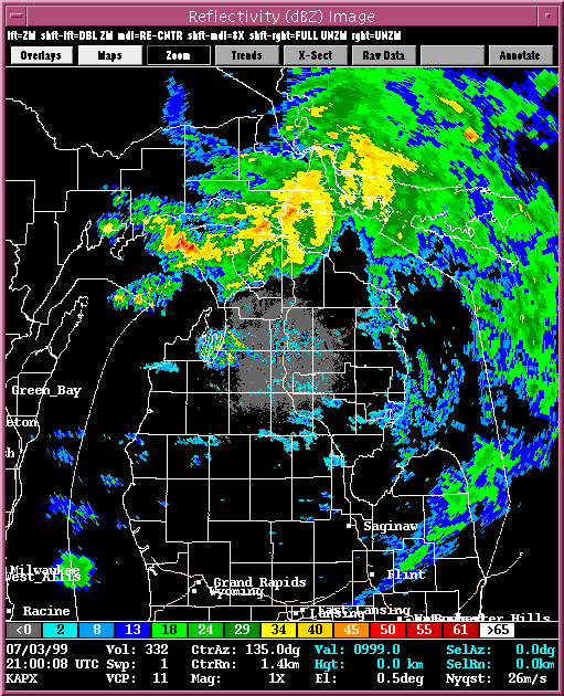
A supercell formed over the Northern Lower
Peninsula of Michigan on the evening of July 3, 1999. The storm moved east-southeast
bringing heavy rains and strong winds as well two reported tornadoes.
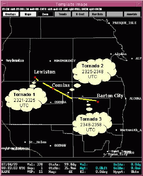
The original report listed the second and third tornadoes as a
continuations from the previous county, thus the original reports listed 1 tornado,
crossing 3 counties with, a total path of 29 miles.
Since tornado segments are recorded in STORM DATA by counties, it is not unusual
to see one tornado that crossed county borders reported as more than one tornado.
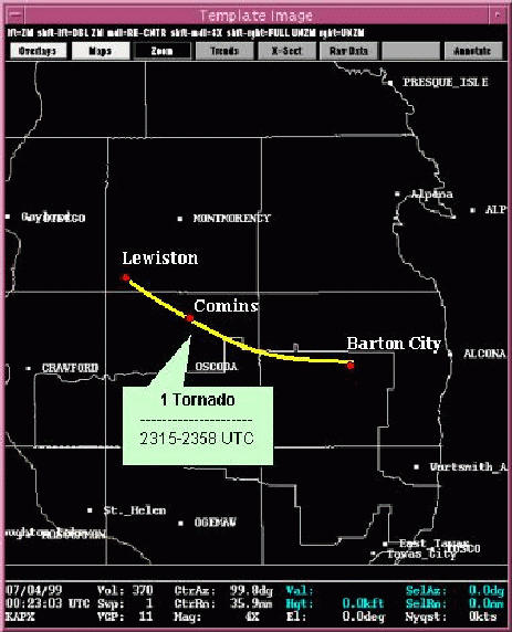
So we adjusted the path of the tornado slightly to reflect a single tornado
that crossed into three counties. When taking a further look at the reported path of
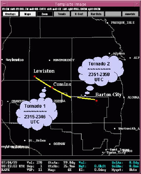
the tornado and the WSR-88D radar it appeared as if there were
two tornadoes that had occured.
This is a case of a cyclic supercell and clearly shows an occluding mesocyclone with the new
mesocyclone forming out ahead.
Presented here are various WSR-88D radar
images from the Gaylord, MI radar (KAPX). Included in some of the WSR-88D
images, there is output from NSSL's Mesocyclone
Detection Algorithm
(MDA) and Tornado
Detection Algorithm. A yellow circle depicts a mesocyclone. The red-in-yellow
circle depicts a mesocyclone whose base is at the lowest elevation scan
(where it is a more likely tornado threat). A red triangle indicates the
location of a tornado as detected by the TDA.
Overview of the day
-
- Reflectivity loop (21:00-00:23).
-
A Closer Look
- Reflectivity loop (23:21-00:03).
- Storm Relative Velocity (SRV) loop (23:21-00:03).
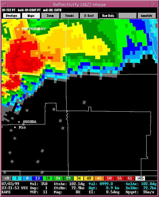
DESCRIPTION:
The reflectivity loop was constructed using the base
reflectivity at half hour intervals. It shows a supercell developing
over the Gaylord, MI area and moving east-southeast. As the storm intensifies a F1
tornado develops near the Montmorency/Oscoda County line around 7:21 pm EST (23:21 UTC). The
tornado strengthened to an F2 and passed through the city of Commins, MI ,dissipating
around 7:48 pm EST (23:48 UTC). A second tornado occurred beginning near the Huron State Forest
and the Alcona County (the county to the east of Oscoda) line from approximately
7:51 pm EST (23:51 UTC) to 7:58 pm EST (23:58 UTC). A closer look at the
base reflectivity and storm relative
velocity while the storm is tornadic are shown. The loops are approximately
5 minute intervals at the 0.5 degree elevation angle. One thing to note in these loops
is the border of the Huron National Forest, which can be seen as the white
horizontal line that separates the Oscoda County name from the Mio City name on the images.
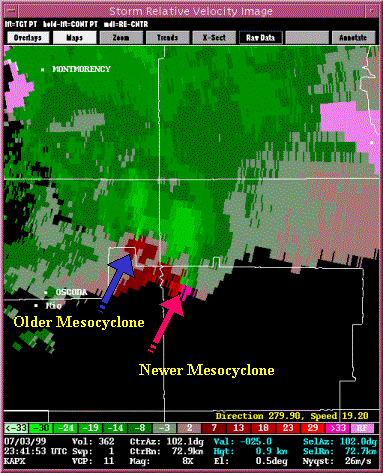
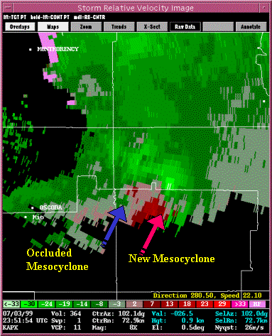
The Occlusion
-
- SRV at 23:43 UTC
- SRV at 23:51 UTC
DESCRIPTION:
The WSR-88D radar was able to capture the cyclic nature of the supercell as seen in the
above images. At 23:41 UTC the first tornado and
associated mesocyclone can be seen while to the east a larger area of rotation has developed.
At 23:51 UTC the mesocyclone associated with the first
tornado has begun to weaken at lower levels while the new mesocyclone begins to dominate.
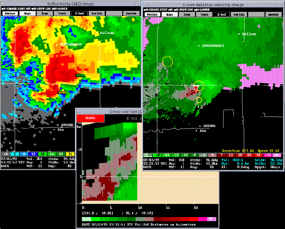
Various Images
-
- Cross Section at 23:21 UTC.
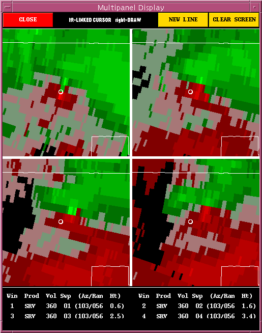
- SRV 4 panel at 23:31 UTC.
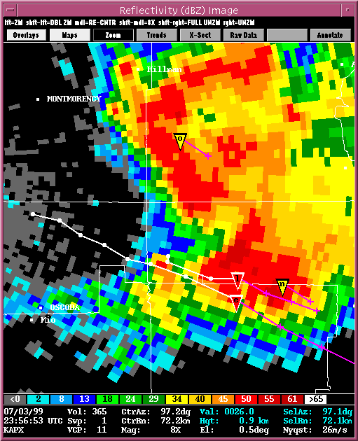
- Reflectivity at 23:56 UTC
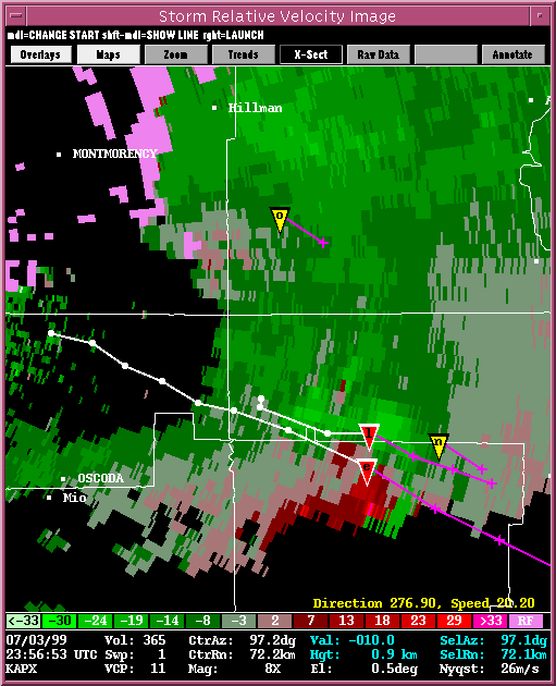
- SRV at 23:56 UTC
DESCRIPTION:
A cross section taken at 23:21 UTC shows the
vertical structure of the supercell from the southwest to the northeast shown by the white line.
The 4 panel image of SRV taken at 23:31 UTC shows a
well defined TVS that is tilted to the northeast with height. A small white circle
is present as a reference point for the viewer. On the
base reflectivity and
storm relative velocity images at 23:56 UTC the TDA algorithm and the associated
TVS tracks (previous track shown in white and future tracks shown in purple) are shown.
The TDA algorithm identifies two tornadoes, e and l, along approximately the same track
as the observed damage path. Notice how close to two paths are just north of the state forest.
The damage survey team may not have noticed a break in the damage and associated the damage to
one tornado. The TDA algorithm is also in agreement that there may have been two
separate tornadoes on the evening of July 3, 1999.
|
Return to NSSL SWAT Case Study Page
Return to NSSL SWAT Page
|