Weather radar highlights of NSSL's first 40 years
...continued
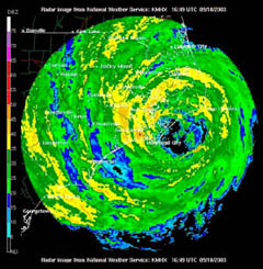
Eyewall of a hurricane crossing the Outer Banks southwest of Cape Hatteras.
NWS Implementation
NSSL’s research helped convince the NWS that Doppler radar was a crucial forecasting tool. Beginning in the mid-1980’s, NSSL worked to make Doppler radar data useful for NOAA NWS forecasters in preparation for a national deployment of the radars. During field programs like DopLight, Doppler radar and lightning data were provided in real-time to both the Oklahoma City Weather Forecast Office and local TV media. Various algorithms were developed to detect and notify forecasters of hail, severe thunderstorms, tornadic circulations, downbursts and gust fronts (the leading edge of rain-cooled air), and track the movement of storms. These algorithms were later combined with a color display system and became known as the Warning Decision Support System.
Largely based on this work, and JDOP , the national network of 150 WSR-88D (Weather Surveillance Radar- 1988 Doppler) radars, or NEXRAD (short for NEXt generation RADar ) were deployed in the early to mid-1990’s, jointly developed and operated by the NOAA NWS, Department of Defense and Federal Aviation Administration throughout the United States and selected overseas locations. The NEXRAD project replaced the older WSR-57 radars and now provides comprehensive radar coverage of the United States.
In 1997, NSSL received a Gold Medal from the Department of Commerce for work leading up to and their support of the national NEXRAD deployment. All the while many other scientists worked to find valuable clues in the data that were being produced.
Other Advances in Doppler/NEXRAD Technology
During the 1990's, NSSL designed and implemented software for NEXRAD's Open Radar Product Generator. The ORPG processes Doppler radar data and generates products for use by NEXRAD customers. Other NSSL teams worked on NEXRAD's Open Radar Data Acquisition Unit to improve how basic data is acquired and to allow for future enhancements as needs of the industry change.
NSSL's 20 years of polarimetric weather radar research were rewarded in the fall of 2003 following JPOLE, the Joint Polarization Experiment . JPOLE proved the engineering design and quality of data provided by a polarimetric radar would benefit operational users. The NOAA NWS recently approved taking the first steps to upgrade all the WSR-88D Doppler radars in the NEXRAD network with polarimetric technology .Polarimetric capabilities will complement information the Doppler radars already provide on wind, precipitation and storm motion. Another important discovery was that dual-polarization improved rainfall estimates with the 25 WSR-88D radars in the western United States where radar beams were blocked by mountains.
The Collaborative Radar Acquisition Field Test or "CRAFT," was another milestone as researchers from NSSL, the University of Oklahoma, the NWS Radar Operations Center, the University Corporation for Atmospheric Research-Unidata, Internet-2, and the National Climatic Data Center were able to prove that access to high-resolution data from multiple radars was technically possible and economically viable. As a result, high-resolution radar data from the national network of NEXRAD radars will soon be available over the Internet in real-time to government, university and private sector users.
NSSL is also heading a project to seamlessly mosaic all NWS and Department of Defense WSR-88D radars across the United States to provide the first high-resolution depiction of storms and quantitative precipitation estimates from coast to coast in real-time.