Weather radar highlights of NSSL's first 40 years
By Susan Cobb
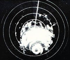
Hurricane Carla as seen by WSR-57 radar at Galveston, Texas. Arrow designates location of tornado which occurred near Kaplan, Louisiana. Monthly Weather Review, December 1962, p. 515.
Who would have imagined that radar technology designed to detect and locate hostile aircraft and missiles in WWII would serve as the basis for today's advanced weather radar systems. At that time, storms were a nuisance that obscured valuable data. Later, however, users realized the potential benefits of radar for weather detection. Now, the NOAA National Weather Service relies daily on radar to detect, locate and measure precipitation inside clouds. In fact, today's radars are so advanced they can even identify types of precipitation, detect important weather features that make a storm severe, and track and predict the motion of storms.
NOAA National Severe Storms Laboratory
Much of the credit for modern weather radar systems should be given to the NOAA National Severe Storms Laboratory in Norman, Okla., which celebrated its 40th anniversary in mid-October. “We want to take this time to savor our accomplishments over these past 40 years and look optimistically toward the future,” said James F. Kimpel, NSSL director.
NSSL Background
Established in 1964, the NOAA NSSL leads the way in investigating all aspects of severe and hazardous weather. NSSL is part of NOAA Research and is the only federally supported laboratory focused on severe weather. NSSL's scientists and staff explore new ways to improve understanding of the causes of severe weather and how to use weather information to assist NOAA National Weather Service forecasters, as well as federal, university and private sector partners.