RECORD SNOWFALL in UPPER MIDWEST- DEC 2000 

Bob Rabin1,2  and Scott Bachmeier2
NOAA/National Severe Storms Laboratory, Norman, OK1
Cooperative Institute for Meteorological Satellite Studies, University of Wisconsin-Madison2
    After several mild winters, the upper Midwest experienced near record low temperatures and high snowfall during the month of December 2000.

    For example, the mean temperature in Madison was 11.2 F as compared to the December average of 21.7 F. This was 0.4 F above the record low of 10.8 F.

    The temperature was subfreezing continuously except for 2 brief periods on the 3rd and 4th when high temperatures reached 34 and 35 F respectively.

    The mean minimum temperature was 2.0 F. The temperature fell below zero (-18 C) on 13 days with -21 F (-29.5 C) the coldest on the 25th.

    Waterloo IA set a monthly minimum record with -29 F on 25 December..
 

    Madison:

     Measurable snow fell on 20 days giving a record total of 35" for the month.

     The heaviest was 8.2" on the 18th, followed by 5.0" on the 11th, 4.6" on the 20th.

     Total liquid equivalent for the month was only 1.39" giving an average snow/liquid ratio of almost 30 to 1.
     Most snowfall occured when the temperature was between 5-15 F. In some cases the snow/liquid ratio was as high as 40 to 1.

     The highest Madison snow depth of 17" tied for the greatest December snow depth.
 

    Milwaukee:

     Milwaukee set a new snowfall record of  49.5" in December. This broke the previous record of 27.9" by almost 22"!

     Snowfall in Milwaukee was occasionally enhanced by northeasterly flow over Lake Michigan.
     The 13.6" on the 11th was the greatest December single-day snowfall

     There was as much as 32" of snow on the ground at MKE late in the month.

     Climate data from Wisconsin are available from the NWS MKE  (Milwaukee/Sullivan) Web page.
 

    Iowa:

    By the 21st, the average snowfall from all stations across the state was 19.8" - already a new record for December

      Snow depth reached 31" across northeast Iowa (29 December at Tripoli).
 

     Other record Midwest snowfall for December:

     Marquette MI                 89.5" *
     Grand Rapids MI             59.2 " *
     South Bend IN                    44.6 "
     Saginaw MI                         40.3 "
     Dubuque IA                         37.6"
     Rochester MN                     35.3" *
     Waterloo IA                         34.0"
     Rockford IL                         30.1" *
     Green Bay WI                     28.9"
     Des Moines IA                     26.9"
     Springfield MO                      18.0"
     Tulsa, OK                                11.4"
     Oklahoma City OK                 8.2" (.8" short of record)

        * - record snowfall for any month (see link from NWS Central Region)
 

    The abnormally cold snowy December was due to the frequent delivery of arctic air and passage of perturbations in northwesterly flow aloft. A high latitude blocking pattern was accompanied a persistent high amplitude central/eastern trough, western ridge at mid latitudes.  Fig. 1  and  Fig. 2  show the geopotential height (m) mean and anomaly patterns at 500 mb for December 2000 (obtained from the NOAA Climate Diagnostics Center interactive website). Note the closed high just south of Greenland and the ridge stretching from the west coast of Canada north through Alaska to another closed high north of Siberia.
      This is similar to the general pattern described in the winter outlook (issued this December) by the Climate Prediction Center. As described in their winter outlook, the pattern is characteristic of the low index phase of the arctic oscillation (Fig. 3) where high pressure is dominant near the north pole and the negative phase of the North Atlantic Oscillation (Fig. 4) where blocking is observed near southern Greenland. Note that most of the winters in the 1990's were dominated by the high index phase of the arctic oscillation (lower pressure near the pole) and a positive phase of the North Atlantic Oscillation (low pressure near Greenland). The arctic oscillation appears to have a connection with stratospheric temperature changes, for example see the Annular Modes Website . This December 2000 pattern finally broke down during the first week in January 2001 with the onset of more zonal flow preventing the southerly penetration of arctic air into the U.S.
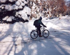
      Photos of the landscape in Madison WI taken by the author on the morning of 21 December can be viewed by clicking here.  These were taken along the bicycle route to work near the University of Wisconsin-Madison campus. The temperature was 0 F (-18 C), skies were clear, and winds were gusting from the west in the wake of a departing clipper system. Some interesting satellite and ground scenes of the ground blizzard in Iowa that day can be found here.
 
      For a view of the snowcover as viewed from Scott's deck on 20  December click here.