7.4 APPLICATION OF
SHORT-RANGE NWP MODEL ENSEMBLES
TO SEVERE STORM FORECASTING
Harold E. Brooks
David J. Stensrud
Charles A. Doswell III
NOAA/ERL/National Severe Storms Laboratory
Norman, Oklahoma
1. INTRODUCTION[ ]
The use of ensembles in numerical weather prediction (NWP) has become common at
national forecasting centers recently (e.g., Tracton and Kalnay 1993; Molteni
et al. 1995), although the notion of combining forecasts to improve accuracy
has been around for some time (Thompson 1977). Most of the operational effort
has been directed towards medium-range forecasting (e.g., 5-14 days).
Information from the ensemble about the large-scale flow has proven to be
useful from a forecasting perspective (Tracton 1994). The use of
higher-resolution models focusing on short-range forecasting (0-48 hours) was
discussed by Brooks and Doswell (1993) and Harrison (1994). Recently, the
National Meteorological Center (NMC) began running an ensemble of ten members
of the 80-km horizontal grid spacing version of the Eta model (Black 1994) on a
weekly basis. This is part of a pilot project to look at Short-Range Ensemble
Forecasting (SREF). The project is described in Brooks et al. (1995).
Briefly, the different forecasts are initialized using six different analyses,
prepared routinely at NMC, and with two pairs of perturbation prepared using
the method of breeding of growing modes (Toth and Kalnay 1993). Error
characteristics of the ensembles have been discussed by Hamill and Colucci
(1996). Here we use one case from the SREF experiment to motivate discussion
of the use of ensembles on the 0-48 hour time range, focusing on the potential
utility of SREF for the forecasting of severe convection.
2. MESOSCALE MODELS IN FORECASTING
The use and interpretation of mesoscale model output for short-range
operational forecasting of severe convection presents challenges and
opportunities not found in longer-range forecasting. In particular, the time
scale implies a desire to know details of the environmental conditions not
necessary on the longer range, where a general feel for the situation may be
all that is needed or possible. Cortinas and Stensrud (1995) discussed the use
of output from an individual mesoscale model forecast. They suggested that the
use of model-predicted fields such as Convective Available Potential Energy
(CAPE) and Storm-Relative Environmental Helicity (SREH) could be useful in
identifying areas of potential supercell thunderstorm threats.
Another approach, of course, is to consider the areas in which the model
generates convection. As Cortinas and Stensrud (1995) point out, this forces a
reliance on the accuracy of the convective parameterization, which may or not
be a good idea, depending on the situation. There is the further problem that
the parameterization scheme acts to eliminate the conditions that led it to
initiate convection. Thus, in the absence of high temporal sampling of the
model, it may be impossible to determine operationally the nature of the
environment in which the convection formed.
Ensemble forecasting presents an opportunity for short-range, high resolution
models to be used for the forecasting of severe convection in new ways. Severe
convection is by its nature a rare event at any one location and it represents
the concatenation of processes and ingredients in such a way that what may seem
like a very low probability event many hours in advance becomes a much higher
probability event as time goes on. The use of multiple forecasts in an
ensemble setting may provide insight into this process.
3. 9 MAY 1995 FORECAST
One of the first ensembles run was initialized on 9 May 1995 at 1200 UTC.
Briefly, there was a small outbreak of strong to violent tornadoes in northern
Illinois on the evening of the 9th. Severe weather became more widespread on
the 10th, affecting much of the area from eastern Ohio through central
Pennsylvania, south to northern Georgia and Alabama. Isolated severe weather
reports occurred in Florida,
Louisiana,
and Texas on the 10th. Our concern here is the main body of severe weather on
the 10th and we will consider the CAPE as an example of the prediction of
environmental conditions and the model forecast convective precipitation for
the following period.
Severe reports consisting mostly of hail and high winds marched relatively
rapidly across Ohio into western New York and central Pennsylvania from about
2000 UTC to 0000 UTC on the 11th associated with a line of convection. At the
same time, the southern end of the convective line moved much more slowly to
the south out of eastern Kentucky into Tennessee and western North Carolina.
The 36-h ensemble forecast of CAPE valid 0000 UTC 11 May shows a region of at
least moderate CAPE (greater than 800 J kg-1 extending from the
Louisiana Gulf Coast northeast towards Pennsylvania. From the spread between
the largest area and smallest area forecast (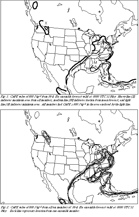 Fig. 1), it is clear that the
ensemble members agree much more about the portion of the forecast domain in
Tennessee, where the convective line advanced slowly, than in the northern
mid-Atlantic States, where the line moved rapidly. This is also apparent in
the "spaghetti" plot, showing the isolines for all ten members (
 Fig. 2). This
implies that the ensemble has greater confidence in the exact location of the
high CAPE air in the southern portion of the domain than in the northern. This
is not surprising since a large part of the uncertainty in the forecast had to
do with the speed of movement of the system.
There are two members of the ensemble (including that from the "early" Eta
analysis) that produce a relative minimum in CAPE in eastern Tennessee (see
Fig. 2), near where the observed convection occurred after 0000 UTC on the
southern part of the convective line. The convective precipitation forecast by
the ensemble after 0000 UTC is extremely interesting in this regard. Despite
having two members producing little in the way of instability, the maxima in
convective precipitation in the ensemble mean occurs in eastern Tennessee (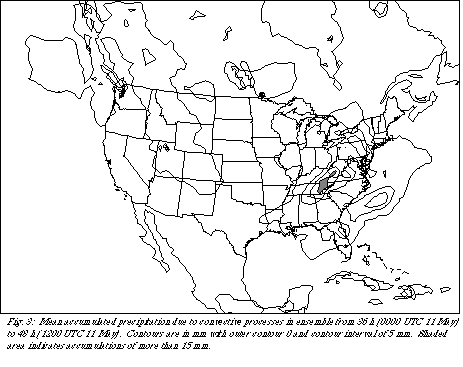 Fig. 3). Maximum precipitation due to the convective parameterization in this
region is over 17 mm in the 12 hour period in the mean forecast. The
maximum from any individual member is over 25 mm, with eight generating a
maximum on the order of 20 mm or more in eastern Tennessee. Thus, on the
whole, the ensemble forecasts a high probability of significant rainfall
associated with convection (and presumably strong convection in eastern
Tennessee). Depending on other parameters, such as SREH, a forecaster in that
region might be
alerted to the potential for severe weather and flash flooding overnight.
4. DISCUSSION
Forecasting of hazardous weather is becoming a more important part of
operational meteorology. It requires a knowledge of atmospheric behavior on
all spatial and temporal scales. Ensemble forecasting offers an opportunity to
provide significant value in developing guidance for operational forecasting,
particularly as we move towards using higher spatial resolution models with
more frequent temporal sampling. The ability of high-resolution models
generating very precise, but potentially inaccurate forecasts is
a real danger (Brooks and Doswell 1993, Cortinas and Stensrud 1995). Ensembles
can provide help in this regard and enable forecasters to assess their
confidence in numerical guidance in a particular situation.
Several things must be done for SREF to be consistently useful for forecasting
of severe weather. First, we need to understand the predictability of the
relevant forecast fields. Much is known, for example, about the model
predictability of 500 hPa heights, but little is known about the predictability
of CAPE. Second, techniques to group members of the ensemble into clusters of
similar atmospheric behavior based on the relevant physical parameters of
interest for a given forecast, rather than on large-scale flow similarity, need
to be tested. The fact that the parameters of interest may change from day to
day makes this more challenging.
Finally, it is likely that the ensemble will have to be expanded greatly (O~100
members) in order to maximize the utility of the forecasting of rare, severe
weather. We found clusters of 8 members that forecast heavy precipitation in
eastern Tennessee over a 12-hour period, while two other members produced
little precipitation. In reality, the sample size is too small to have
confidence in the probability of events. Large ensembles are needed if we are
going to provide guidance with significant value for forecasters. Related to
this point, techniques to monitor the evolution of the ensemble (and cluster)
members and the atmosphere are needed, so that the transition from
low-probability event to high-probability event characteristic of rare, severe
weather can be tracked. For example, suppose that only two or three members of
100-member ensemble produce the right conditions for a major hazardous weather
occurrence, but that the "path" the atmosphere must follow to get there,
according to the model, is clear. It is unreasonable to assume that a
forecaster will be familiar with the evolution of all 100 members of the
ensemble. Automated means that alert the forecaster to the fact that what
initially appeared to be an unlikely scenario has become more likely, as the
atmosphere evolved, would be useful in raising awareness.
5. ACKNOWLEDGMENTS
We want to thank everyone involved in the SREF project, particularly Eric
Rogers at NMC and Danny Mitchell at NSSL who have helped put the data sets from
the experiment together and have written software to help read and display the
data. The SREF WWW home page is at
<URL: http://antietam.nssl.uoknor.edu/
mosaic_files/sref.html>
4. REFERENCES
Black, T. L., 1994: The new NMC mesoscale eta model: description and forecast
examples. Wea. Forecasting, 9, 265-278.
Brooks, H. E., M. S. Tracton, D. J. Stensrud, G. DiMego, and Z. Toth, 1995:
Short-range ensemble forecasting: Report from a workshop (25-27 July 1994).
Bull. Amer. Meteor. Soc., 76, in press.
______, and C. A. Doswell III, 1993: New technology and numerical weather
prediction--a wasted opportunity? Weather, 48, 173-177.
Cortinas, J. V., Jr., and D. J. Stensrud, 1995: The importance of
understanding mesoscale model parameterization schemes for weather forecasting.
Wea. Forecasting, 10, in press.
Harrison, M. S. J., 1994: Ensembles, higher resolution models and future
computing power -- a personal view. Weather, 49, 398-406.
Hamill, T. M., and S. J. Colucci, 1996: Random and systematic errors in NMC's
Eta short-range ensembles. Preprints, 13th Conference on Probability
and Statistics, (San Francisco, California), Amer. Meteor. Soc., in press.
Molteni, F., R. Buizza, T. N. Palmer, and T. Petroliagis, 1995: The ECMWF
ensemble prediction system: Methodology and validation. Quart. J. Roy.
Meteor. Soc., in press.
Thompson, P. D., 1977: How to improve accuracy by combining independent
forecasts. Mon. Wea. Rev., 105, 228-229.
Toth, Z., and E. Kalnay, 1993: Ensemble forecasting at NMC: The generation of
perturbations. Bull. Amer. Meteor. Soc., 74, 2317-2330.
Tracton, M. S., and E. Kalnay, 1993: Operational ensemble prediction at the
National Meteorological Center: Practical aspects. Wea. Forecasting,
8, 379-398.
______, 1994: Operational ensemble prediction - The NMC experience.
Preprints, Tenth Conference on Numerical Weather Prediction, (Portland,
Oregon), Amer. Meteor. Soc., 206-208.
 Fig. 1), it is clear that the
ensemble members agree much more about the portion of the forecast domain in
Tennessee, where the convective line advanced slowly, than in the northern
mid-Atlantic States, where the line moved rapidly. This is also apparent in
the "spaghetti" plot, showing the isolines for all ten members (
 Fig. 2). This
implies that the ensemble has greater confidence in the exact location of the
high CAPE air in the southern portion of the domain than in the northern. This
is not surprising since a large part of the uncertainty in the forecast had to
do with the speed of movement of the system.
 Fig. 3