Just after midnight on this day, a bow-echo squall line thunderstorm system traversed across Central Oklahoma. The apex of the bow echo aimed directly at Norman, Oklahoma. Severe wind damage occurred within the city of Norman. The severe wind damage appeared to be associated with shallow vortices, or misocyclones, along the leading edge of the bow echo. These kinds of vortices are now being observed across the country, now with the deployment of the nationwide WSR-88D network. Noteable examples have occurred near St. Louis on several occasions. Other cases occured with a derecho complex that moved across northern New York State on 15 July 1995, and near Minneapolis on 1 July 1997.
Presented here are various WSR-88D radar images from the Oklahoma City/Twin Lakes radar (KTLX).
The big question is: are these tornadoes? Given current understanding of squall-line, or Quasi-Linear Convective System (QLCS) tornadoes, I would lean toward 'yes'. In fact, I observed one vortex in situ at NSSL, accompanied by a loud roar and estimated wind gusts to 95 mph. Damage occurred across the street at the NWSFO/Norman and 1/4 mile north at Max Westheimer Airport.
THE BOW ECHO (KTLX Loops)
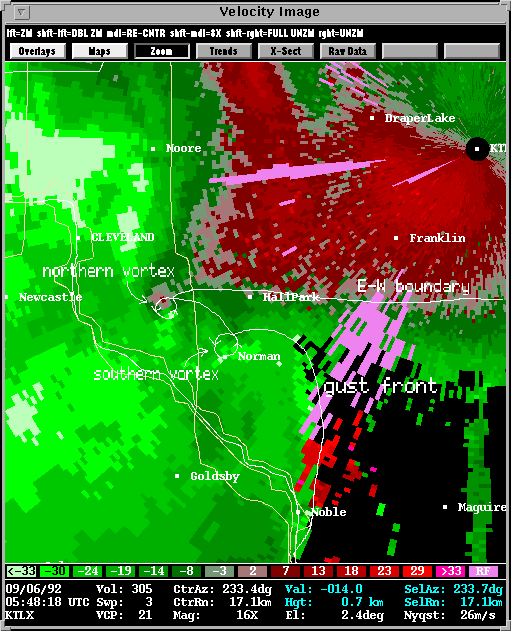
Description: The apex of the bow echo passed directly across Norman. The leading edge of the bow was marked by a strong gust front. Also, a pre-existing E-W boundary was evident in the WSR-88D data (velocity at 2.4 degrees elevation), which intersected the bow-echo gust front at or just north of its apex. At these boundary intersections, a series of shallow vortices, or misocyclones developed, several of which were responsible for narrow swaths of F0 to F1 damage.
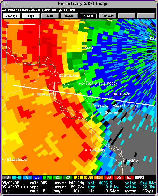
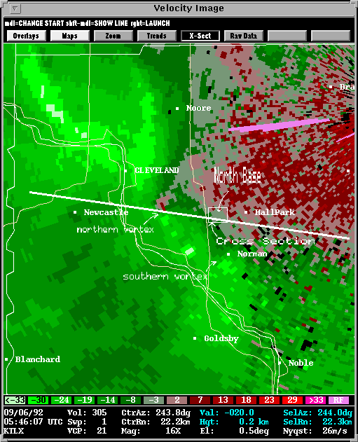
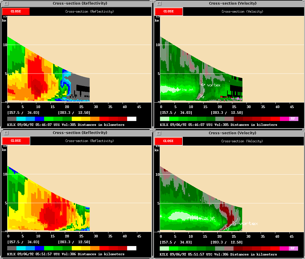
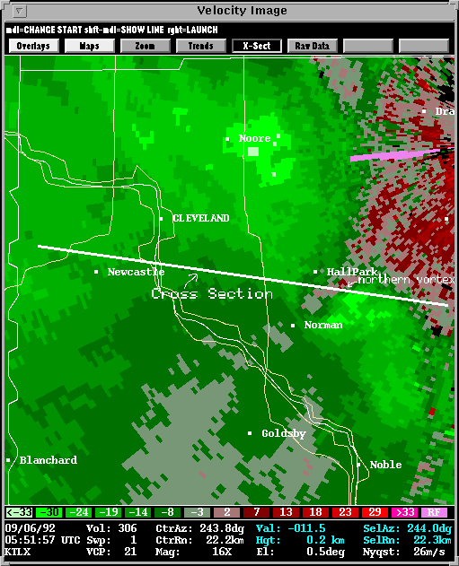
This 0546 UTC image shows the reflectivity associated with the bow echo within 5 minutes of hitting Norman. The velocity image shows the well developed vortex just east of Newcastle. The roughly E-W white line across these images represents the line in which a cross section was taken along the path and tilt of this northern vortex (0546 UTC is shown as the top two panels). Another vortex is also observable near the dot representing downtown Norman. Both vortices were responsible for two separate damage paths across the city of Norman. The northern vortex was more intense, resulting in 95-105 mph (~45-50 m/s) wind gusts across "North Base" in northern Norman. Here, there was damage reported at the National Severe Storms Laboratory, the National Weather Service Forecast Office, and one building was completely destroyed. Several aircraft at Westheimer Field were also damaged or destroyed. Both vortices are easier to see in the storm-relative velocity image at 0546 UTC.
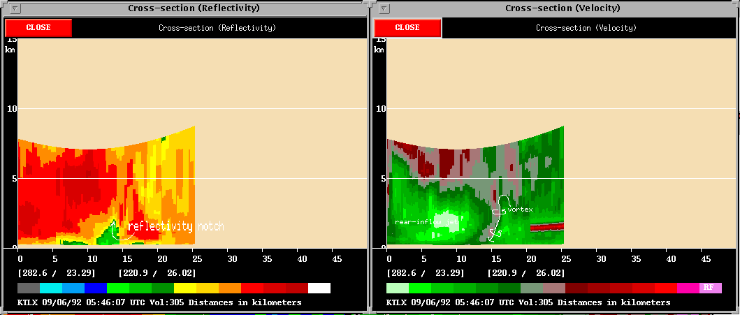
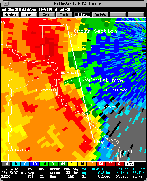
Here is another cross-section at 0546 UTC. This cross section is taken perpendicular to the path of the northern miscocyclone vortex (see this reflectivity image to see the line representing this second cross-section).
Some interesting things to note with the 0546 UTC images. The reflectivity image shows a distinct weak-echo notch wrapping in the north side of the northern vortex. This notch is overhung by precipitation about 2 km AGL, as evedenced by the cross-section taken perpendicular to the vortex path. The velocity images presented here are the ground-relative images. This is done to show how the vortex affected the ground, and explains some of the damage patterns. Most of the damage was done in narrow paths, with damage being blown in one direction (except in a small area near downtown Norman). On the 0546 UTC velocity image, the inbound half of the vortex is registering 30 m/s velocities. The outbound portion of the vortex is showing 12 m/s velocities. An Oklahoma Mesonet observing station, located just N of Westheimer Field, and about 1/2 mile north of the damage path on North Base only reported a wind gust of 20 m/s. It appears that the winds on the south side of the vortices was augmented by the storm motion, whereas the winds on the north sides of the vortices was dimished by the storm motion.
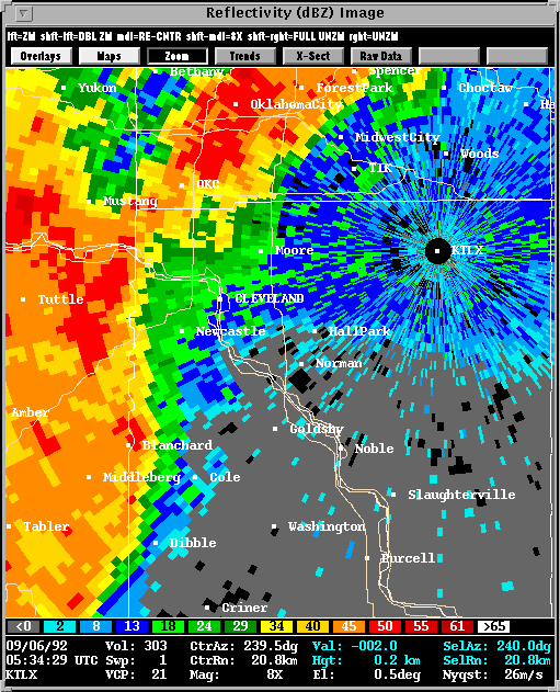
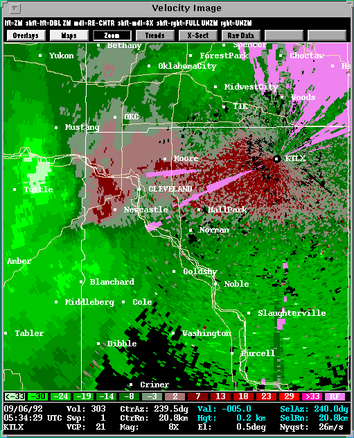
At 0551 UTC, the southern vortex that passed across Main Street in Norman had dissipated. The northern vortex continued, moved to the ESE, and caused more damage in east Norman. Here are the reflectivity and velocity images at 0551 UTC. Also, the bottom two panels of the cross-section depict the 0551 UTC time.
A paper on this event, "Observations of lower-tropospheric misocyclones
along the leading edge of a bow-echo thunderstorm", by Stumpf and Burgess,
was published in the Preprints, 26th Conf. on Radar Meteorology.
In the future, we may post this paper on the Web. This paper presents
a dual-Doppler analysis of the event, as Doppler radar data were also collected
at the NSSL Cimarron radar in Yukon, Oklahoma. The paper will hopefully serve
as a backbone to any future studies and publications of these types of vortex
phenomena.
![]()
Back to NSSL SWAT Case Study Table of Contents Page.