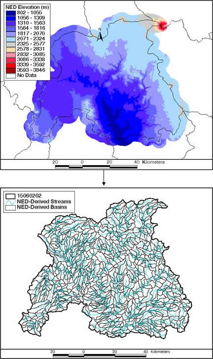
Digital elevation data from the NED is used to derive the
stream network and define flash-flood-scale basin boundaries
Project Overview
This project involves the delineation of flash-flood-scale
basins for use in the NWS FFMP system. Implemented in the Advanced
Weather Interactive Processing System (AWIPS), FFMP is used to
assist in flash flood warning decisions at 121 Weather Forecast
Offices (WFOs) throughout the country. FFMP is based on the Areal
Mean Basin Estimated Rainfall  (AMBER)
Program developed by Bob Davis and Paul Jendrowski. It computes
basin average precipitation rates and accumulations from the WSR-88D
Digital Hybrid Scan Reflectivity product, and updates these values
with each volume scan of the radar. The accumulations are then
compared to NWS Flash Flood Guidance (FFG) values or to user-defined
threshold values to determine flash flooding potential. (AMBER)
Program developed by Bob Davis and Paul Jendrowski. It computes
basin average precipitation rates and accumulations from the WSR-88D
Digital Hybrid Scan Reflectivity product, and updates these values
with each volume scan of the radar. The accumulations are then
compared to NWS Flash Flood Guidance (FFG) values or to user-defined
threshold values to determine flash flooding potential.
The basin delineation was performed using ESRI's
ArcView and ARC/INFO geographic information system (GIS) software,
and was based on the National Elevation
Dataset (NED).
Produced at the EROS Data Center (EDC),
the NED is a seamless mosaic of the highest-resolution, best-quality
elevation data for the United States. It was available for use
in this project through a Memorandum of Agreement (MOA) with
the EDC.
Delineated basins were assigned unique IDs
using the Pfafstetter system of basin codification (Verdin,
1997 ).
This system defines basins according to the natural topographic
control of drainage and the topology of the river network. Hydrologic
ordering and relationships can be easily extracted from the Pfafstetter
IDs, adding versatility to the basin dataset.
The initial FFMP basin datasets were completed
and delivered via CD to each CONUS WFO during the period from
September 2001 to July 2002. The initial datasets include the
following shapefiles:
- Aggregated Basin Shapefile (xxxx_aggr_basins)
- Radar Bin Center Point Shapefile (xxxx_bins)
- National Hydrography Dataset (NHD )
Streams Shapefile (xxxx_nhd_rch)
- National Hydrography Dataset (NHD )
Waterbody Shapefile (xxxx_reg_nhd)
- Original Basin Shapefile (xxxx_orig_basins)
- Synthetic Streams Shapefile (xxxx_str_gen)
Enhanced FFMP basin datasets with hydrologic
connectivity attributes were completed and delivered via CD to
all WFOs during the period from April 2003 to September 2004.
The enhanced datasets include the shapefiles listed above plus
the following two:
- Basin Shapefile (non-aggregated) with Hydrologic Connectivity Attributes
(xxxx_ref_basins)
- Synthetic Streamlink Shapefile with Hydrologic Connectivity
Attributes (xxxx_ref_sl)
The hydrologic connectivity attributes enable
the use of the shapefiles with the ArcView
Basin Customization Extension .
The Basin Customization Extension contains helpful tools for
editing and customizing the FFMP basin and stream shapefiles.
In addition, the extension's tools for tracing
downstream flow paths and defining
upstream drainage help dataset users to better
understand the hydrologic network. |

)
)