|

Purposes
and Programs of the
U.S. Weather Bureau National Severe Storms Laboratory
Norman, Oklahoma
Edwin
Kessler
Director, National Severe Storms Laboratory
1. INTRODUCTION
The needs for more accurate, timely, and meaningful weather information grow as production, transportation, and communication processes become more intricate and more weather-sensitive. Aviators, agriculturists, builders, shippers, and insurers are among those who increasingly depend on information concerning the present and forecast occurrences of storm hazards.
Development of the national weather system to meet national needs efficiently depends on the application of findings of basic and applied meteorological research. Modern technology has produced numerous research tools whose coordinated-use should contribute importantly to improved understanding of the meteorological processes associated with severe storm development, to more accurate weather analysis and forecasting, and to eventual beneficial modification or control of weather including severe storms.
The National Severe Storms Laboratory aims to extend our understanding of severe convective phenomena such as tornadoes, hailstorms, and heavy rains. For the study of these phenomena, modern weather radar is an indispensable tool, and considerable specialization in techniques of radar data display and processing, including synthesis of radar data with other kinds of information, is required. It is natural, therefore, that the Laboratory also serve the Weather Bureau as a research facility for development and applications of radar to general meteorology and the national weather system.
2. OBJECTIVES AND PROGRAM GUIDELINES
The Laboratory objectives in the national interest are:
1. To gain new knowledge of the morphology and dynamics of severe storms, such as heavy rains, squall lines, thunderstorms and tornadoes, and thereby to contribute to the development of improved forecasting, and understanding.
2. To discover improved methods for collecting, analyzing, and processing severe storm data, and to stimulate development of equipment, especially radar equipment, holding promise of expanded capabilities.
3. To study operating configurations of men and equipment, and thereby to contribute to the design of improved storm observing and reporting systems wherein sensors, processors and communications facilities are efficiently meshed to provide timely, accurate information to the host of users.
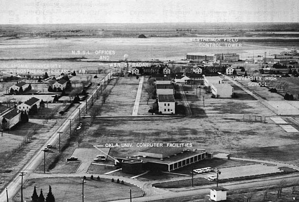
The National Severe Storms Laboratory has objectives of investigation formerly addressed by the National Severe Storms Project at Kansas City, Mo. and by the Weather Radar Laboratory at Norman, Okla., and will emphasize the applications of radar and aircraft probes, and surface networks of closely spaced automatic recording stations for these studies. A great variety of severe weather occurs near Norman, and the co-located University of Oklahoma and its Atmospheric Research Laboratory will furnish important and unique support to the Laboratory mission (figure 1).
|
Figure 1. Aerial view showing University of Oklahoma Research Park, Norman, Oklahoma, with buildings housing the USWB's National. Severe Storms Laboratory, and other facilities. |
The shape of the NSSL program at a particular time will naturally be determined by the interests and capabilities of participating personnel. The national problem of skilled manpower shortage will certainly be reflected in the scope of the program. A few highly qualified specialists will be retained as consultants, and every reasonable effort will be made to attract capable people with interests in all the physical and mathematical disciplines needed to advance meteorological frontiers.
The decision to work on a particular task will be based on considerations of the importance of the problem, the reasonableness of the proposed approach to a solution, and the adequacy of available resources to secure a desired useful result.
Financial resources, equipment, and facilities authorized for NSSL management will be allocated to in-house or contractor control on a basis of estimated benefits per unit expenditure. Many intangibles enter such estimates. Government, university, and commercial enterprises have distinctive characteristics which may determine the type of facility best suited to particular tasks.
Organization of the National Severe Storms Laboratory is outlined in figure 2. The Laboratory is responsible to the Office of Meteorological Research, and will receive guidance from consultants drawn from institutions of government, commerce, and education. The interests of other agencies will be made known through the office of the Chief, U.S. Weather Bureau, and by contacts at other levels.
The activities of research and equipment development shown in figure 2 are the Laboratory's raison d'etre. All other activities are supporting and their value will be judged in terms of their support effectiveness.
Not all of the activities suggested by figure 2 will be fully staffed by NSSL employees. Some activities may be staffed by contractors or by the employees of other government agencies. Some work may be funded by transfer of monies to NSSL management from other agencies.
|
Figure 2. General organization of NSSL, Norman, Oklahoma. In practice, it is common for single individuals to participate in different activities |
During past seasons, weather reconnaissance and weather penetration aircraft of cooperating agencies and of the U.S. Weather Bureau have been used with observations of radar and a network of closely-spaced surface observation stations, and with synoptic data, to describe atmospheric states and physical processes associated with thunderstorms and related weather systems. Findings and conclusions have been documented in the reports of the National Severe Storms Project [1-19 and others, in press]; these are important to the planning of future work.
The coordinated use of modern observing equipment will continue to be emphasized at NSSL; important and difficult tasks will be the design of experiments to take greatest possible advantage of complementary observational capabilities.
Of course, it is not possible at the outset to map the forthcoming program in detail. Foci of effort will be determined by need and the availability of good ideas and sufficient resources. Some problem areas which may receive active attention at NSSL are discussed briefly in the following sections:
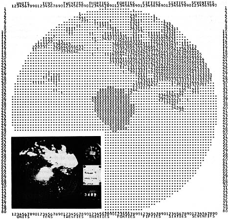
A. Measurement of precipitation rate by radar - This task requires correlation between radar and rain gage observations and will utilize digital computers for radar data processing (see fig.3) and assembly of rain gage data from stations maintained by the Laboratory* and the Agricultural Research Service, Chickasha, Okla. ** Austin [20], Wilson [21] and others have demonstrated the potential accuracy of the WSR-57 for rainfall measurements in widespread precipitation. Their works must be extended to include many cases of highly variable precipitation. It is expected that radar can provide information of rainfall occurrences so timely and accurate that flash-flood forecasting will be greatly improved, with resultant saving of lives and property and more economical utilization of reservoirs and hydroelectric facilities. The tasks of applying precipitation rate-radar echo relationships to problems of stream flow and ground water are within the jurisdiction of the Office of Hydrology, U.S. Weather Bureau; the Corps of Engineers, U.S. Army; and the Department of Agriculture.
Accurate measurement of precipitation rate on a small scale should also contribute to establishment of criteria for severe storm identification and to analysis of the water and energy budget of storms: knowledge of budget parameters is essential to the understanding of storm mechanics.
|
Figure 3. Digitized distribution of radar echo intensities within 100 nm. of Norman, Okla., August 7, 1963, as produced by a computer from series of WSR-57 radar observations. A photograph of the plan position indicator with high radar sensitivity is also shown. |
B. Application to air traffic control of ground-based weather radar and sferics equipment - Incidents associated with flights of aircraft in the vicinity of thunderstorms have emphasized the need for more knowledge of associations between thunderstorm echoes and turbulence and improved application of observing tools to problems of air safety. With the aid of ground-based radars, high-performance aircraft will be vectored through and near thunderstorm areas while sferics counts and distributions of radar reflectivity are simultaneously recorded.*** These data should reveal the frequency distributions of significant parameters of atmospheric turbulence, electricity, and hail which are characteristic of particular altitudes, and of radar and sferics indications. Findings should provide a basis for rational estimation of the economic and human factors associated with flight through particular weather conditions and, thus, for operational decisions which incorporate these factors.
C. Doppler radar - Doppler radar [22] can measure the radial speeds of scattering elements, hence can be a basis for deducing much information about winds [23], and probably holds the greatest potential of all the new tools for expanding man's knowledge of wind fields accompanying precipitating weather systems. Doppler data can be used to infer distributions of precipitation particle size, and contribute to understanding of the microphysical processes fundamental to precipitation production [24, 25]. Recent applications of Doppler have contributed to better understanding of the nature of radar echoes from invisible sources, the radar "angels," and suggest advanced techniques which may provide a needed breakthrough in the study of clear-air turbulence [25, 26].
The width of the Doppler spectrum from precipitation depends on the variation of radial speeds among the scattering particles and may be a measure of aircraft-sensed turbulence; an R-meter [27] attachment permits a conventional radar to estimate spectrum width also [28]. NSSL will use aircraft with Doppler and conventional radars to search for a suitable means for identifying locations of severe turbulence quickly and economically. Research success would be quickly translated into benefits for aviation meteorology.
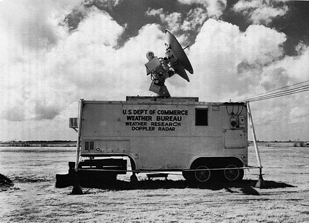
The application of Doppler techniques to meteorology is rather new and special signal-processing techniques are necessary; at present there are very few, Doppler weather facilities. Because of the great potential of Doppler radar, NSSL is developing an installation for use by its staff and other meteorologists (fig. 4 and [29]).
|
Figure 4. Mobile X-Band pulsed Doppler radar at NSSL. At present, peak power is 6 kw. and the pulse repetition frequency is variable to 10 kc./sec. half-power beamwidth is 1.39 |
D. Wind and water distributions and energy conversion and transport processes - Our capabilities for forecasting and controlling severe storms will be advanced by knowledge of associated air circulations and energy transformation processes; this requires that observations observation must be used, because significant storm details are distributed on small space and time scales. Aircraft should provide photographs, from which the shape of clouds can be accurately mapped, and measurements of temperature, pressure, wind, and water content (fig. 5); radar reflectivity data can be a basis for estimates of 3-dimensional distributions of precipitation content; the observations of surface stations separated by mesoscale lengths provides rainfall and wind data essential to water budget considerations, and the surface distributions of pressure and temperature. These considerations have been discussed in detail by Braham [30], Atlas [31], and Fujita [32], for example.
At NSSL, a great part of the program will be devoted to developing improved syntheses of severe storm observations and theories. In this regard, the ideas of Lhermitte [23], Browning [33], Kessler [34], and 0gura [35] suggest important possibilities.
|
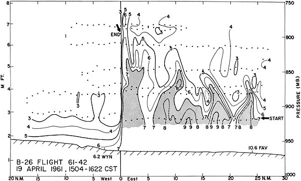
Figure 5. The importance of aircraft observations is illustrated by this cross-section of the water vapor distribution across a dry line in northwestern Oklahoma. The locations of observations made along the aircraft flight path are indicated by dots. The vertical orientation of the zone of abrupt moisture change, its extremely narrow horizontal extent, and details of the moisture distribution in the humid air could not be delineated except from aircraft measurements. |
E. Statistical characterization of weather patterns, and implications - The development of applications for radar-derived and satellite-derived information has been slowed in part by difficulties of objective pattern description. The availability of large high speed digital computers now permits advances in this important area [35, 36, 37, 38]. For example, objective measures of pattern bandedness and orientation, the characteristic length of pattern elements, and pattern motion and development can all be determined with computer-performed correlation routines. The average radar-echo intensity, the intensity variance, and the proportional area covered by echoes have been shown to discriminate among radar echo patterns. Since pattern parameters are correlated with each other! not all are essential to a comprehensive description of pattern statistics. The description of a weather pattern by a minimum number of variables is important to the economical communication of weather intelligence.
The relationship of radar echo and satellite photograph pattern parameters to severe storm occurrences and to synoptic weather features is important to the coordinated use of the conventional observing tools with the new. Studies like [38] which relate the predictability of scale weather patterns to other pattern descriptors should be extended. Techniques such as multiple discriminant analysis [39] should be used in this work.
Other important problems concern relationships among statistical properties of storm patterns and the associated turbulence, momentum and energy transport and conversion processes, and the large scale flow.
F. Meteorological systems analysis and advanced instrumentation - Studies of various configurations of men and equipment are necessary to incorporate new techniques for observing and reporting storms into effective operational routines. System studies may be undertaken at the request of the Systems Development Office and other sponsoring organizations and in partnership with responsible groups; in some cases, Laboratory personnel may have consulting roles. Reports of such studies will include recommendations concerning needs for specialized equipment ([41- 42, 43, 44], for example) for operational data collecting, processing, and communicating.
In the research programs, much data may be usefully reduced by hand and processed in established facilities, but development and procurement of some specialized equipment will probably also be necessary. The effective combination for research purposes of data from aircraft/ radar and mesonetwork sources, and the speedy, comprehensive analysis and recording of Doppler radar spectra, for example, may depend on equipment development or procurement by the Laboratory.
Important results of NSSL investigations will be offered as soon as possible after their completion for publication in scientific journals. The prepublication series represented by this report will be used for disseminating information more rapidly and in more detail than is practicable via formal publication.
*In spring 1964, a 47-station network for comprehensive mesoscale weather observations; see Appendix.
** In spring 1964, 173 recording rain gages over 1128 sq.mi. for rainfall-runoff studies along the Washita River and tributaries; see Appendix.
***Of course, even high-performance aircraft must be guided to avoid areas where the a priori probability of extremely severe weather is judged to be high.