(Copyright 1994 American Meteorological Society)
On the Environments of
Tornadic and Nontornadic Mesocyclones
Harold E. Brooks[12]
Charles A. Doswell III
Jeremy Cooper[34]
(To appear in Weather and Forecasting, 10, 606-618)
Abstract
We have investigated the differences in the environments associated with
tornadic and non-tornadic mesocyclones using proximity soundings. Questions
about the definition of proximity are raised. As we look at the environments
of severe storms with high spatial and temporal resolution, the operational
meaning of proximity becomes less clear. Thus, our exploration of the
proximity data set is subject to certain caveats, which are presented in some
detail.
Results from our relatively small proximity data set support a recently
developed conceptual model of the development and maintenance of low-level
mesocyclones within supercells. Three regimes of low-level mesocyclonic
behavior are predicted by the conceptual model: (i) low-level mesocyclones are
slow to develop, if at all, (ii) low-level mesocyclones form quickly but are
short-lived, and (iii) low-level mesocyclones develop slowly but have the
potential to persist for hours. The model suggests that a balance is needed
between the midtropospheric storm-relative winds, storm-relative environmental
helicity, and low-level absolute humidity to develop long-lived tornadic
mesocyclones. In the absence of that balance, such storms should be rare. The
failure of earlier forecast efforts to discriminate between tornadic and
non-tornadic severe storms is discussed in the context of a physical
understanding of supercell tornadogenesis. Finally, it is shown that attempts
to gather large data sets of proximity soundings associated with rare weather
events are likely to take many years.
1. Introduction
Supercell thunderstorms, characterized by the existence of a persistent
mesocyclonic circulation, represent an important hazard to the public because
of their connection with severe weather, such as hail, strong winds, and
tornadoes. Burgess and Lemon (1990) indicated that, based on Doppler radar
observations from the Joint Doppler Operational Project (JDOP) experiment,
almost all of the observed mesocyclones were associated with some severe local
storm event (large hail, damaging winds, and tornadoes) and approximately half
produced tornadoes. As a result of the danger, significant effort has gone
into identifying environmental conditions associated with supercells (Browning
1964; Chisholm and Renick 1972 and many others). Darkow (1968; 1969) used the
concept of a proximity sounding, to be defined further below, to identify the
environments associated with tornadoes. Rather than using the whole sounding,
Rasmussen and Wilhelmson (1983) calculated low-level vertical shear of the
horizontal winds and convective available potential energy (CAPE) from 1200 UTC
soundings and proposed that non-rotating thunderstorms are found in
environments with low shear and low CAPE, while tornadic storms occurred with
high shear and high CAPE. More recent work based on similar approaches (e.g.,
Johns et al. 1993; Korotky et al., 1993) extended our knowledge of the range
of tornadic environments to include high CAPE-low shear and low CAPE-high shear
environments.
Darkow's approach to the characterization of the environment is quite distinct
from that of Rasmussen and Wilhelmson. Darkow attempted to put strict limits
on the spatial and temporal variability of the atmosphere at the expense of
eliminating large numbers of cases, leading to questions about the statistical
significance of the work. Also, the product of Darkow's work was a relatively
detailed picture of the vertical structure of environments associated with
tornadic storms. Rather than contrasting the tornadic proximity soundings with
non-tornadic proximity soundings, Darkow compared his proximity soundings to
their nearest neighbors, which he called "check" soundings.
Rasmussen and Wilhelmson, on the other hand, put fewer restrictions on the
atmospheric variability, thus having the capability of producing a large data
set in a relatively short time (although they only used 13 cases), but also
thereby leading to questions about how well the soundings represented the
environment of the storms. Moreover, the product of Rasmussen and Wilhelmson's
approach is a parameter space diagram that includes some partitioning of storm
types to within regions of the parameter space. Turcotte and Vigneux (1987,
results shown in Brooks et al. 1993) followed the methods of Rasmussen and
Wilhelmson with a larger data set using all soundings associated with severe
thunderstorms from three years and all soundings associated with non-severe
thunderstorms from a single year in the forecast area of the Quebec Weather
Centre. They discovered that a simple combination of shear and CAPE could
discriminate well between the environments with severe and non-severe
thunderstorms, but not between tornadic and severe non-tornadic environments.
A long-range goal is to explore whether environmental parameters can help
further by distinguishing between the environments of tornadic
thunderstorms and non-tornadic severe thunderstorms. Here, we consider
the contribution of discriminating between tornadic and non-tornadic
supercells to that goal.
One interpretation of the results of Turcotte and Vigneux is that the
successful discrimination between severe and non-severe thunderstorms is, at
least in part, a result of CAPE and low-level shear predicting the environments
of supercell thunderstorms. While not all severe weather is associated with
supercells and not all supercells produce severe weather, the lack of
discrimination between tornadic and severe non-tornadic thunderstorms using
CAPE and low-level shear could be related to the observations of tornadic
frequency in radar-detected mesocyclones reported by Burgess and Lemon (1990);
i.e., the presence of non-tornadic mesocyclones. Numerical modelling (e.g.,
Weisman and Klemp 1982, 1984) and theoretical studies (Davies-Jones 1984,
Rotunno and Klemp 1985) indicate that low-level shear in
thermodynamically-unstable environments is the origin of rotation in mid-levels
(i.e., 3-10 km AGL) of supercell thunderstorms. It now appears, however, that
in supercells the occurrence of tornadoes is closely connected to the
development of low-level mesocyclones (i.e., below 1 km AGL), which have
their origins in the baroclinic generation of vorticity within
evaporatively-cooled downdrafts (Rotunno and Klemp 1985, Davies-Jones and
Brooks 1993). That is, low-level mesocyclones develop by different processes
than mid-level mesocyclones. If this is a correct picture of supercell
tornadogenesis, such a process is not described by CAPE or low-level shear.
Hence, it should not be surprising that those parameters cannot discriminate
between tornadic and non-tornadic supercell environments.
In assessing the differences between tornadic and non-tornadic environments, a
challenge has been the lack of information about environments producing
non-tornadic supercells. While data sets of soundings associated with tornadic
environments have been developed (e.g., Darkow 1969), the comparable data sets
for severe thunderstorms (e.g., Maddox 1976, Patrick and Keck 1987) have
not necessarily been associated with supercell thunderstorms. Recently,
Wood et al. (1994) have put together a data set of tornadic and non-tornadic
mesocyclones based on observations from the Doppler radars at the National
Severe Storms Laboratory (NSSL). These data have given us the opportunity to
assess proximity soundings associated with both tornadic and non-tornadic
mesocyclones and to see if there are any differences in the environments
associated with them.
After some considerations of the difficulties associated with proximity
soundings and their selection, we describe both the mesocyclone and sounding
data sets. Using the recent work of Brooks et al. (1994, hereafter BDW94), who
proposed a conceptual model of the role of the environment in developing and
maintaining low-level mesocyclones[5], we then
look for differences in the environments associated with tornadic and
non-tornadic mesocyclones. We close with a discussion of the implications of
the results for forecasting and for the development of proximity sounding data
sets for rare events.
2. Problems with the definition of "proximity"
Underlying the use of proximity soundings is the idea that we want to sample
"the environment in which an event formed." However, spatial and temporal
variability within the "environment" of tornadoes and tornadic storms is the
rule, rather than the exception; tornadic storms do not arise often in
environments characterized by spatial and temporal homogeneity (Doswell 1982)
on scales observable with the rawinsonde network. Recognition of this
variability is implicit in Darkow's (1969) definition of a proximity
sounding:
1. The sounding release point is within 50 statute miles (80 km) of a
tornado.
2. The tornado occurred within 105 min after the balloon release (45 minutes
before and one hour after the nominal sounding times at 0000 and 1200 UTC).
3. The sounding sampled the same air mass that gave birth to and sustained the
tornado-bearing thunderstorm.
It is clear that the first requirement relates to the spatial variability
within the environment, the second relates to the temporal variability, while
the third is concerned with elimination of soundings that are not
representative in some sense (including convective contamination). Let us
consider each of these in turn.
The idea of searching for proximity soundings implicitly recognizes that the
environment in which an event occurs is not horizontally homogeneous.
That is, the spatial variation is assumed to be large enough that an event
really needs to be rather close to the sounding release point if the "real"
storm environment is to be sampled; the next closest sounding really won't do.
In fact, the demonstration of that was shown in Darkow's comparison of his
proximity sounding composite with the "check" composite. Darkow's upper limit
on distance, however, is arbitrary and without objective foundation. That is,
there is no quantitative analysis of the spatial variability which might be
present in association with tornadoes, nor is there any sense of the
case-to-case variability of the spatial structure. This is obviously a result
of a lack of observations, a problem which hinders any study of proximity.
In much the same way, the second requirement (i.e., the temporal limit)
recognizes that the tornado environment can change significantly in between
sounding times, even beyond the normal diurnal changes. Some of Beebe's (1958)
findings suggest that the evolution of the environment during the day takes the
resultant sounding well away from the original "loaded gun" sounding, with its
pronounced inversion and dry mid-levels, toward something rather different. In
fact, both Darkow's (1969) and Schaefer and Livingston's (1988) results seem to
bear this out; their composite proximity soundings do not show the capping
stable layer and dry lower mid-troposphere exhibited by the classic "loaded
gun" profiles. However, it might be that at least some of this character
results from a "smearing" of the individual profiles in the compositing process
(see Brown 1993). It is unclear at this time to what extent this smearing
effect influenced the composite proximity soundings, or in any of the
studies creating such composites. As with the spatial variability, the
temporal variability and its case-to-case differences are not well-known and
there is no objective basis on which to establish a temporal cut-off.
Finally, consider the thorny issue of which candidate proximity soundings to
delete from consideration (i.e., criterion #3, above). If the number of
soundings gets too large, it becomes difficult to imagine personally inspecting
each sounding. Moreover, even if the will to examine each individual candidate
sounding is exercised, by whose standards are the soundings chosen for
elimination? As with the other restrictions, this process is not rooted in any
firm ground. Rather, it depends rather strongly on the background of the
analyst; recognition of "problem" soundings is not a trivial issue. As with
the other two constraints, little or no objective basis for development of
standards exists at present. Whereas many soundings can be discarded from
consideration relatively easily (Fig. 1)
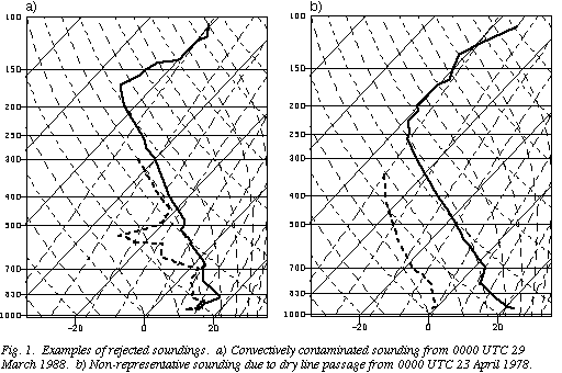 ,
there are occasions when the soundings have more subtle problems that may or
may not be recognized by a particular analyst. Schwartz and Doswell (1991)
have suggested that soundings can have a wide spectrum of technical problems,
some of which might well escape even fairly sophisticated numerical quality
control schemes. In cases with strong mesoscale variability, it is also
possible that soundings may indicate environments that are capable of
supporting convection, but are not representative of the environment in which
the storm forms.
,
there are occasions when the soundings have more subtle problems that may or
may not be recognized by a particular analyst. Schwartz and Doswell (1991)
have suggested that soundings can have a wide spectrum of technical problems,
some of which might well escape even fairly sophisticated numerical quality
control schemes. In cases with strong mesoscale variability, it is also
possible that soundings may indicate environments that are capable of
supporting convection, but are not representative of the environment in which
the storm forms.
We already have seen evidence of this sort of problem when looking at the
Doppler wind profilers in the Profiler Demonstration Network. We have
evaluated the observed time trend of storm-relative environmental helicity, H,
as discussed by Davies-Jones et al. (1990), Droegemeier et al. (1993), and
Brooks et al. (1994), and defined by
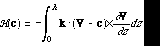 (1)
(1)
where h is an assumed inflow depth, c is the storm motion vector,
V(z) is the environmental wind profile, and k is the unit vector
in the vertical. In several cases, tornadic storms passed close by a profiler
and the observed temporal change in H from the hourly data was what one would
expect: a sustained increase with time prior to the storm's passage. The
6-minute data from one of those revealed a large "spike" in H on a quite short
time scale (Fig. 2)
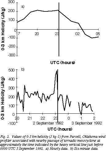 .
In another case, with a supercell passing a profiler during its tornadic
phase, there was little noticeable change in H (Fig. 3)
.
In another case, with a supercell passing a profiler during its tornadic
phase, there was little noticeable change in H (Fig. 3)
 .
Davies-Jones (1993) has examined a large number of special soundings taken on
tornado outbreak days and found significant temporal and spatial variability,
all within a set of what might be considered proximity soundings.
.
Davies-Jones (1993) has examined a large number of special soundings taken on
tornado outbreak days and found significant temporal and spatial variability,
all within a set of what might be considered proximity soundings.
All of this suggests that the notion of "proximity sounding" is potentially a
lot more complex than it might appear to be. It is possible that we can add
significantly to our understanding through model simulation, which is arguably
the most promising way to develop a firm foundation for establishing objective
criteria defining "proximity". What is desperately needed is validation
of the model simulations. It is to be hoped that Verification of the Origins
of Rotation in Thunderstorms EXperiment (VORTEX), scheduled for the springs of
1994 and 1995 (Rasmussen et al. 1994) will be able to accomplish at least some
of this needed validation. With these important caveats in mind, we go on to
consider the currently available data set of proximity soundings to
non-tornadic mesocyclones and compare them to a similarly-obtained set of
proximity soundings to tornadic mesocyclones.
3. Data set
a. Mesocyclones
The mesocyclone data set is taken from that developed by Wood et al. (1994) and
covers those mesocyclones observed from NSSL radars from 1975-1990. The
definition of a mesocyclone is as given by Burgess (1976) and includes criteria
on the shear value, the depth of the circulation, and its temporal continuity.
In order to limit errors in the determination of storm motion, only those
mesocyclones lasting at least 30 minutes are included. We have taken the
mesocyclone motion and location as reported by Wood et al. The associated
severe weather events (hail, damaging winds, or tornadoes) are included with
the data set, based upon reports in Storm Data and annual summaries for
the NSSL Spring Program from 1971-1986.
b. Soundings
Archived soundings from the National Weather Service (NWS) rawinsonde site in
the Oklahoma City area form the basis of most of the data set. In order to
increase the number of soundings in the non-tornadic mesocyclone category, we
also have considered every appropriate case with special soundings taken during
NSSL field programs through 1986. (If a tornadic mesocyclone was also in
proximity to that sounding, it was included in the tornadic data set.)
Two special sets of cases have also been added to supplement parts of the data
set. The first adds to the tornadic cases with soundings from two major
tornado outbreaks. During the 1965 Palm Sunday outbreak (Fujita et al. 1970)
and the 3-4 April 1974 outbreak (Fujita 1974), soundings which met our
proximity criteria (discussed below) were taken as part of the routine NWS
rawinsonde network at Flint, Michigan and Dayton, Ohio, respectively. Given
the nature of the storms on those days, it is virtually certain that they were
supercells.
The second special set adds to the non-tornadic cases. We have constructed
soundings for a set of 6 storms that generated long (~ 100 km), narrow (~ 10-20
km) swaths of winds approaching 50 m s-1, using nearby surface
observations and the closest rawinsonde launch. The environments are
characterized by moderate to high CAPE (more than 2000 J kg-
1)
and significant low-level hodograph curvature leading to high helicity
(approximately 200-400 J kg-
1).
The high helicity distinguishes the environments of these storms from bow echo
situations which have been modeled numerically using straight hodographs
(Weisman 1993). Examples of these storms have been reported by Moller et al.
(1990), Cummine et al. (1992), Brooks and Doswell (1993), and Smith (1993).
Although there are no Doppler radar velocity observations for any of these
events, there is at least some indication in the available radar reflectivity
pictures and other data (interested readers should consult the references) to
suggest that they were supercells. The existence of such storms in distinctive
environments has been suggested by the conceptual model for low-level
mesocyclogenesis of BDW94, which proposes that the storms have mesocyclones but
are outflow-dominated at low levels. The constructed pseudo-proximity
soundings provide information on those environments and are included for
comparison purposes. However, since we have no hard evidence that the storms
were supercells, and since the soundings are constructed, rather than observed
proximity soundings, the cases are clearly distinguished in the analysis that
follows and not included in the statistical comparisons.
c. Determining proximity cases
Our definition of a proximity case was driven by the need to obtain a
reasonably-sized data set, so we began by counting the number of mesocyclone
cases within a given distance to the Oklahoma City sounding site and time of
the synoptic sounding times (0000 UTC and 1200 UTC). Although the total
numbers of tornadic and non-tornadic mesocyclones occurring within 160 km of
the sounding site are roughly the same (Table 1), the tornadic cases dominate
as tighter time and space restrictions are placed on the data. This is
particularly true in the spatial dimension, with 64 of the 112 mesocyclones
(57%) being tornadic within 160 km and 1 hr, while 14 of the 19 (74%) of those
within 40 km and 1 hr were tornadic. If mesocyclones are uniformly distributed
in space in the Oklahoma City area, we would expect a ratio of 1:4:16 events as
the radius of the proximity definition increases from 40 to 80 to 160 km. The
non-tornadic mesocyclones come relatively close to this, showing a slight bias
towards more events being seen near the radar, possibly due to detection
efficiency by the radar algorithm. The tornadic mesocyclones, on the other
hand, are biased heavily towards events near the radar. This is perhaps due to
a bias in the verification of tornadic events, with tornadoes more likely to be
observed and verified in the immediate Oklahoma City vicinity in comparison to
rural Oklahoma.
As a result of the small numbers of non-tornadic mesocyclones near the sounding
site, we chose to make the spatial proximity limit 160 km, larger than that
chosen by Darkow (1969). This definition is as arbitrary as any other
definition of proximity, but is driven by a desire to get a reasonably large
data set. Our choice illustrates the difficulties associated with obtaining
significant number of soundings for rare events. Because of concern with
potentially rapid temporal evolution of mesocyclone environments, the temporal
limit was set at plus or minus 1 hr from the synoptic time. Since
approximately 50-60% of all mesocyclones in the data set occur within 1 hr of
0000 UTC, the temporal restriction did not cut out as many cases as even
halving the spatial restriction would have. Each NWS sounding then was checked
for its representativeness as discussed in Section 2. Soundings were rejected
for three primary reasons: CAPE less than 150 J kg-1, CAPE less
than the convective inhibition (represented by the negative area as a parcel is
lifted on a thermodynamic chart), or soundings which did not extend to 300 mb.
These criteria were chosen to eliminate outflow-contaminated soundings, those
in which significant airmass changes had taken place (e.g., dryline or cold
frontal passage), and to allow for computation of the CAPE. For no obvious
reason, a much larger fraction of the non-tornadic mesocyclones (30 out of the
48, 63%) within 160 km had to be discarded in this step than tornadic
mesocyclones (17 out of 64, 27%). It is possible that this may indicate a
different scale of relevant mesoscale processes for the non-tornadic
mesocyclones, although this idea has not been validated. Soundings associated
with tornadic mesocyclones are more likely to have more than one mesocyclone in
proximity compared to non-tornadic soundings. As a result, the 18 proximity
non-tornadic mesocyclones are associated with 16 soundings, while the 47
tornadic mesocyclones are associated with 28 soundings.
As mentioned previously, 16 special NSSL soundings were used to supplement the
data set, particularly on the non-tornadic side. With the further addition of
the six extreme wind non-tornadic storms and two tornado outbreak cases as
supplemental soundings, the number of non-tornadic mesocyclone soundings (after
eliminating non-representative soundings) was raised to 40 and tornadic
mesocyclones to 52 in the final data set.
4. Conceptual model of low-level mesocyclogenesis
The simple conceptual model of the development and maintenance of low-level
mesocyclones presented in BDW94 focuses on the role of the storm-relative
midtropospheric winds. The model suggests a way to parameterize the problem
using important physical quantities that may distinguish between tornadic and
non-tornadic mesocyclones. For clarity, we include a brief summary of the
conceptual model here.
Rotunno and Klemp (1984) describe the importance of baroclinic generation of
vorticity in evaporatively-cooled air for the development of low-level
mesocyclones within supercells. Davies-Jones and Brooks (1993) show that the
positive vertical vorticity is seen first within the rear flank downdraft of
numerically-modelled storms. BDW94 built upon those results, noting that
another effect of the evaporatively-cooled downdrafts is the generation of
outflow, which can undercut the storm's mid-level mesocyclone. The strength
and longevity of low-level mesocyclones is a function of the balance of
baroclinic generation and outflow development. To evaluate their effects
qualitatively, BDW94 looked at the horizontal redistribution of rain in
numerically-modelled supercells by the mid-level mesocyclone, which acts to
wrap rain around the updraft, and the storm-relative environmental
winds, which act to blow rain away from the updraft. For a given mid-level
mesocyclone circulation, intensifying the mid-level storm-relative winds
increases the amount of rain blown away from the updraft, thereby lessening the
low-level baroclinic generation and the development of strong outflow. For
very weak storm-relative, environmental winds, any low-level mesocyclones will
occur early in the storm's life and will be short-lived, with the outflow
dominating the storm. For very strong storm-relative environmental winds,
baroclinic generation will be small, but so will outflow. As a result, a
low-level mesocyclone might be very slow to develop or perhaps might not
develop at all, but the outflow will be relatively weak. In the middle,
long-lived low-level mesocyclones might result if the mesocyclone circulation
and storm-relative, mid-level winds are balanced in some sense. Thus, the
model of BDW94 predicts three regimes of low-level behavior within supercell
thunderstorms, depending on the balance of the mid-level mesocyclone intensity
and the storm-relative winds over the vertical extent where the mesocyclone and
precipitation co-exist. In the conceptual model, the role of the mid-level
mesocyclone in low-level mesocyclogenesis is to help produce the correct
conditions at low levels by redistributing precipitation. Although it is
conceptually possible for low-level mesocyclones to form in the absence of
mid-level mesocyclones, it appears from observations and model simulations that
convection typically does not develop low-level mesocyclones in the absence of
an existing mid-level mesocyclone.
The conceptual model suggests that it might be possible to distinguish between
those environments associated with supercells that produce low-level
mesocyclones and those that do not by looking at the environmental conditions
associated with mesocyclones and considering parameters pertinent to the
balance suggested in the model. As a measure of the tendency of the
environment to support mid-level mesocyclones, we use helicity (H) defined in
(1), above. While previous studies have fixed the inflow depth (h) as a
constant value, we have set h to be the value less than or equal to 3 km
AGL that yields the greatest value of H for a given profile. An example of the
vertical profile of H as h is varied, illustrating a case where h
would be less than 3 km, is presented in Fig. 4
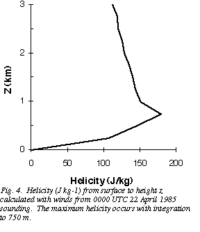 .
Allowing the depth of integration to vary recognizes the importance of
helicity at the lowest levels in the atmosphere. It eliminates cases in which
a thin layer of storm-relative backed winds might obscure the fact that the
low-level environmental air is highly helical and supportive of rotating
convection, as was the case in the soundings associated with the 28 August 1990
Plainfield, Illinois tornadic storm (Doswell and Brooks 1993b). This approach
should provide an upper bound on the value of the actual helicity in the air
flowing into the storm. It is possible that this would lead to an overforecast
of the probability of mid-level rotation within a storm[6].
.
Allowing the depth of integration to vary recognizes the importance of
helicity at the lowest levels in the atmosphere. It eliminates cases in which
a thin layer of storm-relative backed winds might obscure the fact that the
low-level environmental air is highly helical and supportive of rotating
convection, as was the case in the soundings associated with the 28 August 1990
Plainfield, Illinois tornadic storm (Doswell and Brooks 1993b). This approach
should provide an upper bound on the value of the actual helicity in the air
flowing into the storm. It is possible that this would lead to an overforecast
of the probability of mid-level rotation within a storm[6].
Defining the relevant value for the mid-level wind portion of the balance is
not as easy. BDW94 used idealized hodographs and many different ways of
defining the "mid-level wind" would give the same results for those idealized
hodographs. With the complexity of observed hodographs, the issue is
not so clear and different definitions might lead to a different ordering of
the value of the "mid-level wind" for the hodographs. Many options exist for
the definition, including the maximum wind, the minimum wind, or the average
wind. For each of those options, the wind could be defined at a single level
or through some depth. After investigating a number of options, we chose to
use the minimum value between 2 and 9 km altitude of the storm-relative wind
averaged over a depth of 1 km. Winds were interpolated to 250 m heights and
converted into a storm-relative frame of reference. The average for a 1 km
depth was found from 2 km through 9 km for each hodograph. The minimum value
(vmin) then was used as our measure of the mid-level storm-relative
wind. Physically, a low value for vmin represents a significant depth
over which precipitation is not blown away from the mesocyclone, which leads to
outflow dominating the low levels of the storm, cutting off the inflow.
Although they only used one thermodynamic profile in their numerical model
simulations, BDW94 speculated that the thermodynamic structure could play an
important role. In particular, the amount of moisture available at low levels
of the storm should affect the amount of precipitation generated and, as a
result, the potential for evaporation and baroclinic generation of vorticity.
If an important step in low-level mesocyclogenesis is the horizontal
redistribution of rain, then increasing the low-level moisture content means
that the mesocyclone does not need to be as "efficient" at moving rain towards
the rear flank region of the storm in order to get significant vorticity
generation. Thus, the maximum water vapor content (qmax) in the
boundary layer might be an important physical variable in low-level
mesocyclogenesis. While using this measure of moisture fails to take into
account the potential evaporation of precipitation at low levels[7], the soundings in the data set tend not to be
saturated at low-levels. Thus, for our cases, there is sufficiently dry
air at low levels for evaporation to take place and qmax acts as a proxy
for the amount of evaporation. If our data set, or future expansions of the
data set, includes saturated low-level environments, some measure of the
relative humidity will need to be included to address the evaporation question
more completely. As it is, with the present data set, we could not distinguish
any role of low-level relative humidity . Numerical model results have
suggested that it is difficult to develop low-level mesocyclones in saturated
environments, although a systematic study has not been carried out (Brooks et
al. 1993).
5. Results
We have calculated many parameters of the soundings for all 92 mesocyclones in
the data set and will briefly present two results. Davies (1993) indicated
that most strong tornadoes occur for values of Energy-Helicity Index (EHI)[8] greater than 1 and violent tornadoes occur
with EHI greater than 2.5. When EHI is calculated for our data set, including
non-tornadic mesocyclones, however, it is seen that while EHI does a good job
of defining environments with radar-observable mesocyclones, it does not
discriminate well between tornadic and non-tornadic mesocyclones (Fig. 5)
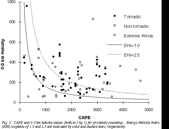 .
This is not surprising; such a result is expected since the parameters
leading to EHI (CAPE and helicity) are not directly related to the development
of low-level mesocyclones. Although we have only shown this one
example, similar results occur when other, related combinations of low-level
shear and instability are used. Identification of environments producing
rotating storms appears rather good, but the discrimination between tornadic
and non-tornadic supercells is poor. Coupled with the Turcotte and Vigneux
(1987) result, such parameters should be useful for identifying supercell
environments but not determining whether supercells will produce tornadoes or
not. Thus, these parameters are important in the severe weather forecasting
process but additional information is necessary if we are going to make the
next step in forecasting tornadoes.
.
This is not surprising; such a result is expected since the parameters
leading to EHI (CAPE and helicity) are not directly related to the development
of low-level mesocyclones. Although we have only shown this one
example, similar results occur when other, related combinations of low-level
shear and instability are used. Identification of environments producing
rotating storms appears rather good, but the discrimination between tornadic
and non-tornadic supercells is poor. Coupled with the Turcotte and Vigneux
(1987) result, such parameters should be useful for identifying supercell
environments but not determining whether supercells will produce tornadoes or
not. Thus, these parameters are important in the severe weather forecasting
process but additional information is necessary if we are going to make the
next step in forecasting tornadoes.
Since the conceptual model of BDW94 makes predictions about the development of
low-level mesocyclones within supercells by considering the "balance" between
the helicity and the storm-relative mid-level environmental winds, its
validation against our observations is a critical test. In order to make
visualization of the results easier, we divided H by vmin to reduce the
two components in the wind balance down to one variable. A large value of
H/vmin indicates that the mesocyclone circulation should dominate the
mid-level winds, leading to outflow-dominated storms in the BDW94 model. Small
values of this ratio indicate domination by the environmental winds, leading to
little vorticity and outflow generation.
The observations (Fig. 6)
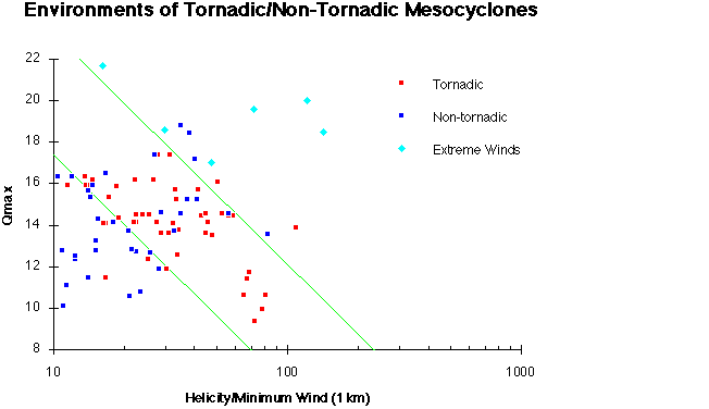 can be interpreted to reveal three regions, consistent with the BDW94
conceptual model. Tornadic storms form in the middle for a given value of
qmax and the region of tornadic mesocyclones on the diagram slopes
towards lower values of H/vmin as qmax increases. The high
H/vmin -high qmax regime is dominated by the non-tornadic
extreme wind events, as predicted by the conceptual model. The low qmax
regime includes the average environmental conditions for low-precipitation (LP)
supercells, as described by Bluestein and Parks (1983), who pointed out that
tornadoes are not characteristic of LP storms. Some simple statistical
measures can be used to test the discrimination between tornadic and
non-tornadic mesocyclones in Fig. 6. If the results are treated as categorical
forecasts of tornado/no tornado, given the presence of a mesocyclone in
mid-levels, then a contingency table of our results can be constructed, where
the forecast is based on using the subjectively-determined two parallel dashed
lines on Fig. 6 as guidelines of discrimination (Table 2). Considering
tornadic mesocyclones as "hits" and non-tornadic mesocyclones as "misses", the
discrimination is quite good and offers encouragement that forecasting of
actual tornadic environments, rather than mid-level mesocyclone environments,
may be possible.
can be interpreted to reveal three regions, consistent with the BDW94
conceptual model. Tornadic storms form in the middle for a given value of
qmax and the region of tornadic mesocyclones on the diagram slopes
towards lower values of H/vmin as qmax increases. The high
H/vmin -high qmax regime is dominated by the non-tornadic
extreme wind events, as predicted by the conceptual model. The low qmax
regime includes the average environmental conditions for low-precipitation (LP)
supercells, as described by Bluestein and Parks (1983), who pointed out that
tornadoes are not characteristic of LP storms. Some simple statistical
measures can be used to test the discrimination between tornadic and
non-tornadic mesocyclones in Fig. 6. If the results are treated as categorical
forecasts of tornado/no tornado, given the presence of a mesocyclone in
mid-levels, then a contingency table of our results can be constructed, where
the forecast is based on using the subjectively-determined two parallel dashed
lines on Fig. 6 as guidelines of discrimination (Table 2). Considering
tornadic mesocyclones as "hits" and non-tornadic mesocyclones as "misses", the
discrimination is quite good and offers encouragement that forecasting of
actual tornadic environments, rather than mid-level mesocyclone environments,
may be possible.
6. Discussion
We wish to emphasize some important concerns about our results, particularly
with respect to the size of the data set. First, there are questions about the
possibility of nonrepresentative soundings that aren't obviously
nonrepresentative, as discussed in Section 2. We cannot have complete
confidence that the soundings actually represent the environmental conditions
in which the storms formed. Second, the verification data set may have errors;
the strong bias towards tornadic mesocyclones in the immediate Oklahoma City
area indicates the possibility that storms farther away from the urban area are
not being reported in the same way as the nearby storms. It is possible that a
tornado associated with a supercell may, in fact, not be associated
with a low-level mesocyclone of that storm, such as in the case of
"gustnadoes" and "landspouts" (Doswell and Burgess 1993). At this time, the
size of the data set for very near soundings (less than 40 km) is so small for
the non-tornadic mesocyclones that we cannot even test this hypothesis.
Finally, there are large areas of the parameter space that have not been
sampled. It is possible that those conditions occur infrequently in the
atmosphere, but it also is possible that we simply have not sampled them in
this limited data set.
The proximity sounding data set is not sufficient to test the BDW94 model
adequately. An independent, larger data set is needed with observations from
other geographic locations. It is somewhat instructive to consider the impact
of the proximity criteria we used on the future development of a data set of
proximity soundings for mesocyclonic storms, as detected by the
operationally-deployed WSR-88D radars[9]. If
we assume the occurrence of reported tornadoes implies the presence of
low-level mesocyclones, we can use the reported tornado climatology to estimate
the frequency of obtaining mid-level mesocyclone proximity soundings. In turn,
this leads to an order-of-magnitude estimate of how long it would take to
acquire a data set of 250 soundings (as done by Maddox 1976). Since no
climatology of non-tornadic mesocyclones exists, we make the assumption that
the spatial distribution of non-tornadic mesocyclones is similar to that of
tornadoes. On the basis of the tornado climatology of Kelly et al. (1978),
about 1/17 of the total number of tornadoes that occur within 160 km of
any of the network rawinsonde sites are, in fact, within 160 km of the
site at Oklahoma City. That is, the frequency of tornado proximity soundings
nationwide should be about 17 times that of Oklahoma City. Since, in the 16
years of our study, 23 non-tornadic mesocyclones were in temporal
proximity to the NWS sounding at Oklahoma City, we can use the ratio of
non-tornadic to tornadic mesocyclones from our study to estimate that about 25
non-tornadic mesocyclones would be sampled by a proximity sounding nationally
each year. Thus, it should take roughly 10 years of national rawinsonde data
collection with WSR-88D observations to collect 250 non-tornadic proximity
soundings nationally. Given the uncertainties in developing this estimate, a
bound of 5-20 years might be reasonable for gathering this large data set.
Observations in special field projects (e.g., VORTEX) could be used to
supplement the data set and decrease that time.
Turning to the question of finding proximity soundings for events observed with
the operationally-deployed WSR-88D radars, it is clear that the problem with
obtaining a sufficient number of cases is the infrequency of soundings in both
space and time, relative to the space and time scales of the events in
question. By expanding the definition of "proximity" one can obtain greater
numbers of proximity soundings, but presumably this would be at the expense of
smearing out the results owing to temporal and spatial variability of the
environments.
A potentially useful method for trying to establish proximity criteria would be
to use numerical models to simulate the evolution of the environment. To begin
with, a mesoscale model could be run for a large number of tornadic (or
mesocyclone) events, and then assess the spatial and temporal variability. To
the extent that the model atmosphere behaves similarly to the real atmosphere,
it could provide useful information on the atmospheric variability. This would
be non-trivial, because it would be necessary to stratify the cases according
to the nature of the events in question; when considering tornadoes, it would
be extremely important to distinguish supercell tornadoes from non-supercell
tornadoes. For mesocyclones, it might be quite relevant to distinguish between
different supercell types (Moller et al. 1994).
The difficulties don't stop there, however. We have evaluated the changes in
pertinent environmental parameters (e.g., CAPE and H) within a numerical cloud
model that was initiated with horizontally homogeneous initial conditions.
Effects of the convection cause large changes in these parameters on time and
space scales comparable to the convective storm and extending beyond the
boundaries of the convective updraft-downdraft couplet into regions of the
environment that show no obvious signs of convective contamination (Fig. 7)
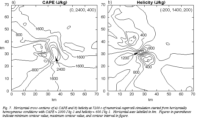 .
Thus, it is possible that a difference of only a few km in space, or a few
minutes in time could result in radical differences in the associated
soundings. In situations where convection is ongoing at release time, these
convectively-forced effects could create a great deal of concern for how to
interpret the observations.
.
Thus, it is possible that a difference of only a few km in space, or a few
minutes in time could result in radical differences in the associated
soundings. In situations where convection is ongoing at release time, these
convectively-forced effects could create a great deal of concern for how to
interpret the observations.
We close by emphasizing the importance of looking at the suggested pattern in
Fig. 6 as a guideline rather than a threshold (Doswell and Brooks
1993a). We deliberately chose a very simple way of partitioning the parameter
space and, as the data set increases in size, it is quite possible that the
actual partitioning may be more complex. Forecasters should be aware that even
if the proximity soundings derived from a large data set do provide accurate
information about the nature of the storms that form, those soundings will, as
a rule, not be available at the time that a forecast is completed. As a
result, the challenge is to anticipate the formation of the environments and to
be aware of the possible weather events associated with likely environmental
conditions. We want to discourage the use of "magic numbers" as a way of
forecasting what is going to occur.
Our results support the idea that in using parameters effectively for
forecasting, the physical relationship between the parameters and the weather
events being forecast must be understood. Whereas the parameter space analyses
employing CAPE and shear parameters show skill in forecasting supercells, they
have not demonstrated any skill beyond the detection of supercells at
tornado/no tornado discrimination simply because those parameters are not
pertinent to all of the processes leading to supercell tornadoes. Thus, they
provide an important step in the forecasting process, but are not complete in
and of themselves. Naturally, there is as yet no complete understanding
of supercell tornadogenesis, but the numerical simulations and observations on
which the conceptual model in BDW94 is based have been given a significant test
within this study and the results support the conceptual model. The conceptual
model may provide another step in the forecasting process since it appears that
some significant skill in discriminating between the environments associated
with tornadic from non-tornadic mesocyclones will be possible in the future.
Development of a firmly-established notion of the tornadic storm environment
could well form an important part of creating tornado warning strategies using
the new WSR-88D radars. Our results suggest that a strategy based on radar
data alone is much less powerful than one which considers parameters based on
observations of the storm environment (profilers, surface observations, etc.)
in combination with the radar-observables.
Finally, although our results show apparent skill in the tornado/no tornado
discrimination task, there are some detection failures and false alarms
scattered within Fig. 6. Given all the uncertainties associated with
forecasting tornado occurrence, a logical suggestion would be to interpret
these results in a probabilistic way. That is, within the parameter space,
there are regions where the probability of a tornado is substantially higher
than in other regions. We have shown a categorical interpretation with two
simple straight lines; given the current limitations of the data set, this
represented the simplest possible interpretation. However, as the proximity
data set grows, future efforts should include construction of tornado
probability contours in this parameter space in a systematic way.
Acknowledgments:
One of the authors (JC) participated in this work while a part of the Research
Experience for Undergraduates program at NSSL sponsored by National Science
Foundation grant No. 125-8650. We thank Mr. Vincent Wood for providing summary
information about the mesocyclone data set and Mr. Ken Howard for helping get
some of the soundings. Dr. Robert Maddox contributed constructive comments
throughout the investigation and Drs. Robert Davies-Jones and Erik Rasmussen
contributed valuable critiques of an early version of the manuscript. The
anonymous reviewers provided many constructive suggestions for clarifying the
presentation.
References
Beebe, R.G., 1958: Tornado proximity soundings. Bull. Amer. Meteor.
Soc., 39, 195-201.
Bluestein, H. B., and C. R. Parks, 1983: A synoptic and photographic
climatology of low-precipitation severe thunderstorms in the Southern Plains.
Mon. Wea. Rev., 111, 2034-2046.
Brooks, H. E., and C. A. Doswell III, 1993: Extreme winds in
high-precipitation supercells. Preprints, 17th Conf. on Severe Local
Storms, (Saint Louis, MO), Amer. Meteor Soc., 173-177.
Brooks, H. E., D. J. Stensrud and J. V. Cortinas Jr., 1993: The use of
mesoscale models to initialize cloud-scale models for convective forecasting.
Preprints, 14th Conference on Weather Analysis and Forecasting, (Vienna,
VA), American Meteorological Society, 301-304.
Brooks, H. E., C. A. Doswell III, R. B. Wilhelmson, 1994: On the role of
mid-tropospheric winds in the evolution and maintenance of low-level
mesocyclones. Mon. Wea. Rev., 122, 126-136.
Brown, R.A., 1993: A compositing approach for preserving significant features
in atmospheric profiles. Mon. Wea. Rev., 121, 874-880.
Browning, K.A, 1964: Airflow and precipitation trajectories within severe
local storms which travel to the right of the winds. J. Atmos. Sci.,
21, 634-639.
Burgess, D. W., 1976: Single Doppler radar vortex recognition: Part I -
Mesocyclone signatures. Preprints, 17th Conf. on Radar Meteorology.
(Seattle, WA), Amer. Meteor Soc., 97-103.
Burgess, D. W., and L. R. Lemon, 1990: Severe thunderstorm detection by radar.
Radar in Meteorology, D. Atlas, Ed., American Meteorological Society,
Boston, MA, 619-647.
Chisholm, A.J., and J.H. Renick, 1972: The kinematics of multicell and
supercell Alberta hailstorms. Alberta Hail Studies, Research Council of
Alberta Hail Studies, Rept. 72-2, Edmonton, Alberta, Canada, 24-31.
Cummine, J., P. McCarthy, and M. Leduc, 1992: Blowdown over Northwestern
Ontario. A Derecho Event - 18 July 1991. Preprints, 4th Workshop on
Operational Meteorology, (Whistler, British Columbia, Canada), Atmos.
Environ. Service/Canadian Meteor. and Oceanogr. Soc., 311-317.
Darkow, G.L., 1968: The total energy environment of severe storms. J.
Appl. Meteor., 7, 199-205.
Darkow, G.L., 1969: An analysis of over sixty tornado proximity soundings.
Preprints, 6th Conf. Severe Local Storms (Chicago, IL), Amer.
Meteor. Soc., 218-221.
Davies, J. M., 1993: Hourly helicity, instability, and EHI in forecasting
supercell tornadoes. Preprints, 17th Conf. on Severe Local
Storms, (Saint Louis, MO), Amer. Meteor. Soc., 107-111.
Davies-Jones, R., 1984: Streamwise vorticity: The origin of updraft rotation
in supercell storms. J. Atmos. Sci., 41, 2991-3006.
Davies-Jones, R., 1993: Helicity trends in tornado outbreaks.
Preprints, 17th Conf. on Severe Local Storms, (Saint Louis, MO),
Amer. Meteor. Soc., 56-60.
Davies-Jones, R., and H. E. Brooks, 1993: Mesocyclogenesis from a theoretical
perspective. The Tornado: Its Structure, Dynamics, Prediction and
Hazards (Geophys. Monogr. 79), C. Church, Ed., Amer. Geophys. Union,
105-114.
Davies-Jones, R., D. Burgess, and M. Foster, 1990: Test of helicity as a
tornado forecast parameter. Preprints, 16th Conf. on Severe Local
Storms, (Kananaskis Park, Alberta, Canada), Amer. Meteor Soc., 588-592.
Doswell, C.A. III, 1982: The Operational Meteorology of Convective Weather.
Vol. I: Operational mesoanalysis. NOAA Tech. Memo. NWS NSSFC-5 (NTIS
Accession No. PB83-162321), 158 pp.
Doswell, C. A. III, and H. E. Brooks, 1993a: Supercell thunderstorms.
Weather, 48, 209-210.
Doswell, C. A. III, and H. E. Brooks, 1993b: Comments on 'Anomalous lightning
in an F5-tornado producing thunderstorm.' Bull. Amer. Meteor. Soc..,
74, 2213-2218.
Doswell, C. A. III, and D. W. Burgess, 1993: Tornadoes and tornadic storms: A
review of conceptual models. The Tornado: Its Structure, Dynamics,
Prediction and Hazards (Geophys. Monogr. 79), C. Church, Ed., Amer.
Geophys. Union, 161-172.
Doswell, C.A. III, R. Davies-Jones, and D.L. Keller, 1990: On summary measures
of skill in rare event forecasting based on contingency. Tables. Wea.
Forecasting, 5, 576-585.
Droegemeier, K. K., S. M. Lazarus, and R. Davies-Jones, 1993: The influence of
helicity on numerically simulated convective storms. Mon. Wea. Rev.,
121, 2005-2029.
Fujita, T.T., 1974: Jumbo tornado outbreak of 3 April 1974.
Weatherwise, 27, 116-126.
Fujita, T.T., D.L. Bradbury, and C.F. Van Thullenar, 1970: Palm Sunday
tornadoes of April 11, 1965. Mon. Wea. Rev., 98, 29-69.
Johns, R. H., J. M. Davies, and P. W. Leftwich, 1993: Some wind and
instability parameters associated with strong and violent tornadoes, 2.
Variations in the combinations of wind and instability parameters. The
Tornado: Its Structure, Dynamics, Prediction and Hazards (Geophys.
Monogr. 79), C. Church, Ed., Amer. Geophys. Union, 583-590.
Kelly, D.R., J.T. Schaefer, R.P. McNulty, C.A. Doswell III, and R.F. Abbey,
Jr., 1978: An augmented tornado climatology. Mon. Wea. Rev.,
106, 1172-1183.
Korotky, W., R. W. Przybylinski, and J. A. Hart, 1993: The Plainfield,
Illinois, tornado of August 28, 1990: The evolution of synoptic and mesoscale
environments. The Tornado: Its Structure, Dynamics, Prediction and
Hazards (Geophys. Monogr. 79), C. Church, Ed., Amer. Geophys. Union,
611-624.
Maddox, R.A., 1976: An evaluation of tornado proximity wind and stability
data. Mon. Wea. Rev., 104, 133-142.
Moller, A. R., C. A. Doswell III, M. P. Foster, and G. R. Woodall, 1994: A
supercell thunderstorm spectrum and its applications in the operational
environment. Wea. Forecasting, in press.
Moller, A. R., C. A. Doswell III, and R. Przybylinski, 1990:
High-precipitation supercells: A conceptual model and documentation.
Preprints, 16th Conference on Severe Local Storms, (Kananaskis
Park, Alberta, Canada), Amer. Meteor. Soc., 52-57.
Patrick, D., and A. J. Keck, 1987: The importance of the lower level windshear
profile in tornado/non-tornado discrimination. Proc., Symp. Mesoscale
Analysis and Forecasting, ESA SP-282, 393-397.
Rasmussen, E. N., J. M. Straka, R. Davies-Jones, C. A. Doswell III, F. H. Carr,
M. D. Eilts, and D. R. MacGorman, 1994: Verification of the Origins of
Rotation in Tornadoes EXperiment: VORTEX. Bull. Amer. Meteor. Soc.,
75, in press.
Rasmussen, E. N., and R. B. Wilhelmson, 1983: Relationships between storm
characteristics and 1200 GMT hodographs, low level shear, and stability.
Preprints, 13th Conf. on Severe Local Storms, (Tulsa, OK), Amer.
Meteor. Soc., J5-J8.
Rotunno, R., and J. B. Klemp, 1985: On the rotation and propagation of
simulated supercell thunderstorms. J. Atmos. Sci., 42,
271-292.
Schaefer, J.T., and R.L. Livingston, 1988: The typical structure of tornado
proximity soundings. J. Geophys. Res., 93, 5351-5364.
Schwartz, B.E., and C.A. Doswell III, 1991: North American rawinsonde
observations: Problems, concerns, and a call to action. Bull. Amer.
Meteor. Soc., 72, 1885-1896.
Smith, B. E., 1993: The Concordia, Kansas downburst of 8 July 1992: A case
study of an unusually long-lived windstorm. Preprints, 17th Conf. on Severe
Local Storms, (Saint Louis, MO), Amer. Meteor. Soc., 588-592.
Turcotte, V., and D. Vigneux, 1987: Severe thunderstorms and hail forecasting
using derived paratmers from standard RAOBS data. Preprints, 2nd
Workshop on Operational Meteorology, (Halifax, Nova Scotia, Canada), Atmos.
Environ. Service/Canadian Meteor. and Oceanogr. Soc., 142-153.
Weisman, M. L., 1993: The genesis of severe, long-lived bow echoes. J.
Atmos. Sci., 50, 645-670.
Weisman, M. L., and J. B. Klemp, 1982: The dependence of numerically simulated
convective storms on vertical wind shear and buoyancy. Mon. Wea. Rev.,
110, 504-520.
Weisman, M. L., and J. B. Klemp, 1984: The structure and classification of
numerically simulated convective storms in directionally varying wind shear.
Mon. Wea. Rev., 112, 2479-2498.
Wood, V. T., R. A. Brown, and D. W. Burgess, 1994: Characteristics of
mesocyclone tracks associated with Southern Great Plains thunderstorms.
Mon. Wea. Rev., (to be submitted).
a) Non-tornadic mesocyclone distribution:
                                          Distance
                     Time             40  80             160
                        1              5  18             48
                        2              8  24             70
                        3              9  30             81
                        6             11  39             98
            NWS Proximity              3  10             18
b)
Tornadic mesocyclone distribution
                                          Distance
                     Time             40  80             160
                        1             14  28             64
                        2             16  36             86
                        3             16  37             90
                        6             21  47             105
            NWS Proximity             10  20             47
Table 1: Distribution of mesocyclones by time and distance from synoptic
sounding time (1200 UTC or 0000 UTC) from the period 1975-1990. Entries in
tables are for number of mesocyclones within the time (in hours) in each row
and distance (in km) in each column. The final entry is the number of
mesocyclones with representative proximity soundings from the NWS rawinsonde
network.
                                         Forecast
                 Observed           Yes  No            Total
                      Yes            43  9             52
                       No             9  25            34
                    Total            52  34            86
Table 2: Contigency table for categorical tornado forecasts using dashed lines
in Fig. 6 as tornadic/nontornadic discriminator. Summary measures of the skill
of the forecast include Probability of Detection = 0.83, False Alarm Ratio =
0.17, Critical Success Index = 0.70, and Heidke Skill Score = 0.56.